InSAR GPS InSAR+GPS JERS-1 InSAR GPS InSAR GIS GPS InSAR LOS Line-Of-Sight GPS GPS SAR GPS SAR GPS SAR JERS-1 SAR InSAR GPS InSAR SAR GSISAR
|
|
|
- れれ のえ
- 5 years ago
- Views:
Transcription
1 InSAR GPS InSAR+GPS JERS-1 InSARGPS InSAR GIS GPS InSAR LOS Line-Of-Sight GPS GPS SARGPS SARGPS SAR JERS-1 SAR InSARGPS InSAR SAR GSISAR GSISAR JERS-1ALOS JERS ALOS2002 JERS SAR GPS1998 SAR
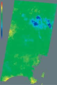
2 2005 No GPS e n u InSARGPS InSAR GPS InSAR InSARGPS InSAR LOS Line-Of-Sight LOS(m) e n u e 1 n 1 u 1 (1) e 1 n 1 u 1 LOS LOS cme n u u u u u 1 (2) u 1 u cm LOS GPS e n u LOS InSAR LOS InSAR GPS InSAR GPS InSAR GPS InSAR GPS InSAR InSAR InSAR InSAR GPS 2004 Munekane et al InSAR SAR km 10m 50m2000 InSAR DEM InSAR simulated interferogramdem InSAR InSAR InSAR 10m 50m DEM 10m 1/ InSAR InSAR InSARInSAR InSAR InSAR 50m
3 2002c TKY2JGD 50m GRS TKY2JGD2002a2002b DEHM 2002c DEHMDigital Ellipsoidal Height Model DEM DEM GRS80 DEHMGPS InSAR InSARDEM DEHM DEHM DEHM InSAR SimDehmH.cgeocodbl.c DEHMSimDemH.c DEM GPS InSAR LOSInSAR SAR InSAR GPS InSAR GPSInSAR GPSInSAR LOSGPS LOS InSAR LOSZa Zb Zc Zd X Y Z Z1 X1 Y Za Y 1 X Zb X 1 Y Zc XYZd (3) Za Zb Zc ZdGPS InSAR LOS 1 GPS GPS InSAR GPS flatgps.c geocoding InSAR Tobita, 1998 LOS B //
4 B // jei2baseh.ckamaboko.c LOS LOS1 GPSInSAR LOSInSAR LOS 10 InSAR SimDemH.cSimDehmH.c LOS ra2enu.c geocodbl.c InSAR DEM DEHM LOSmm 240m LOS ArcView InSARWorld 14 GPSLOS 1 GPS bl2ra.c ra2enu.c enu2phi.c InSAR ra2phi.c GPS e n u fusion_u.c 1998GPS GPS 1995 GEONET InSAR GPS 10cm u cm GEONET InSAR23 InSAR GPS LOS 4.5mm InSARGPS GPS InSAR GPS Gudmundssen, 2002 GPS 2005 No.106

5 GPSe n u, InSAR LOS InSAR LOSGPS InSAR LOSLOS GPS GPS LOS GPS LOS GPS LOS InSAR LOS GPS LOS InSAR GPS InSAR LOSGPS GPS LOSGPS InSAR InSAR+GPS JERS LOS LOS SAR cm GPS u +4.1cm LOS GPS InSARLOS +3.4cm flatgps.c 4.0cm GPS GPSInSAR LOS InSAR GPS 17 LOS InSAR GPS4.6mm


6 2005 No.106 GPS InSAR Kriging

7 InSARGPS 23 InSAR GPS InSAR+GPS GPS InSAR GPS InSAR GPS GPS InSAR InSAR InSAR LOS LOS InSAR+GPS cm InSAR
8 10InSAR InSAR+GPS y y 2.7cm 2.7cmInSAR 10 y mmgps InSAR InSAR+GPS SAR 11InSAR 60m InSAR ArcView cm cm 16cm InSAR GPS TKY2JGD InSAR GIS GPS GIS 16cm 2005 No


9

10 12InSAR Ozawa, et al InSAR InSAR InSAR InSAR LOS InSAR LOS 120m 13 geocodbl.c InSAR JERS-1 SAR 16 InSAR60m 60m InSAR InSAR GMT Generic Mapping Tools InSAR InSAR GMT InSAR GMT 2004 GMT GMT m GMT 1974 GMT m GMT JERS-1 GEONET 2005 ALOS InSAR GEONET 2005 No
11 GPS InSAR+GPS InSAR CInSAR InSAR+GPS GEONET LALOS LALOS GSISAR InSARGPS TKY2JGD InSAR+GPS m GPS InSAR GIS 10m InSAR+GPS InSAR+GPS JERS-1 InSARGPS InSAR GIS GPS L SAR ALOS1200 GPS GEONET 100 GPS 1999SAR P. A. Rosen 1999SAR Gudmundsson, S., F. Sigmundsson, and J. M. Carstensen (2002): Three-dimensional surface motion maps estimated from combined interferometric synthetic aperture radar and GPS data, J. Geophys. Res., 107, 2250, doi: /2001JB Repeat-pass Interferometry GSISARH14InSAR 2004GMTH16InSAR 1995D 1-No.333 Munekane, H., M. Tobita, and K. Takashima (2004): Groundwater-induced vertical movements observed in Tsukuba, Japan, GRL, 31, L12608, doi: /2004gl JERS-1 SAR Ozawa, T., M. Tobita, H. Yarai, T. Nishimura, M. Murakami, H. Ohkura, Postseismic deformation of the 1995 Hyogoken Nanbu Earthquake revealed by JERS-1/InSAR, Abstracts of AOGS 1st Annual Meeting, 57-IWG-A1581, 2004.
12 2005 No SAR a bTKY2JGDNo cDEHM SAR98 P. A. Rosen 1999SAR Tobita, M., S. Fujiwara, S. Ozawa, P. A. Rosen, E. J. Fielding, C. L. Werner, Mas. Murakami, H. Nakagawa, K. Nitta, and Mak. Murakami, Deformation of the 1995 North Sakhalin earthquake detected by JERS-1/SAR interferometry, Earth, Planets and Space, Vol.50, No.4, , 1998.

13
1 () H H E 0084 H k k H H E 0131 H k () H H E 0132 H
 H H E 0084 H k k H H E 0131 H k () H H E 0132 H") 2 H15.3.25 6 H15.4.1 E 0001 H15.4.23 78 2500 467 H15.3.7 137.0 H15.4.4 E 0004 H15.9.30 16000 1722.0k () H15.5.8 H15.4.8 E 0007 H15.10.31 2000 17.2 H15.3.29 H15.4.23 E 0012 H15.6.30 10000 448.7k () H15.5.13
2 H15.3.25 6 H15.4.1 E 0001 H15.4.23 78 2500 467 H15.3.7 137.0 H15.4.4 E 0004 H15.9.30 16000 1722.0k () H15.5.8 H15.4.8 E 0007 H15.10.31 2000 17.2 H15.3.29 H15.4.23 E 0012 H15.6.30 10000 448.7k () H15.5.13

8-5 中国・四国・九州地方の地殻変動
 Crustal Movements in the Chugoku, Shikoku and Kyushu Districts Geographical Survey Institute 1 -(1) (9)GPS 2000 10 6 (Mj7.3) 2 co-seismic 2001 2 2 2000 10 6 310 4 -(1) (6) 5 -(1) (3) 2001 GPS 6 7 GPS 2001
untitled
 * Coseismic and postseismic coastal environment changes caused by the 1703 Genroku Kanto Earthquake in the southern part of Boso Peninsula, central Japan Jun Muragishi Graduate School of Urban Environmental
「諸雑公文書」整理の中間報告
 30 10 3 from to 10 from to ( ) ( ) 20 20 20 20 20 35 8 39 11 41 10 41 9 41 7 43 13 41 11 42 7 42 11 41 7 42 10 4 4 8 4 30 10 ( ) ( ) 17 23 5 11 5 8 8 11 11 13 14 15 16 17 121 767 1,225 2.9 18.7 29.8 3.9
0.45m1.00m 1.00m 1.00m 0.33m 0.33m 0.33m 0.45m 1.00m 2
 24 11 10 24 12 10 30 1 0.45m1.00m 1.00m 1.00m 0.33m 0.33m 0.33m 0.45m 1.00m 2 23% 29% 71% 67% 6% 4% n=1525 n=1137 6% +6% -4% -2% 21% 30% 5% 35% 6% 6% 11% 40% 37% 36 172 166 371 213 226 177 54 382 704 216
 10 117 5 1 121841 4 15 12 7 27 12 6 31856 8 21 1983-2 - 321899 12 21656 2 45 9 2 131816 4 91812 11 20 1887 461971 11 3 2 161703 11 13 98 3 16201700-3 - 2 35 6 7 8 9 12 13 12 481973 12 2 571982 161703 11
JHPCN-FINALv04.pdf
 28 2017 5 jh160029 NAH [1] 5.1 3 FX-10 [2] 5.2 FX-10 [3] 5.3 2016 4 TSUBAME-2.5 10 [4] 5.4 1. (1) (2) (3) GPU GPU TSUBAME FX10 FX10 2. 2011 3 11 M9 1 28 2017 5 M7.3 M6.6 2016 Finite-Difference Time Domain
N H km 10km 20km NAVI
 28 3.1-1 28 N H28 1 2 3 4 5 5km 10km 20km 1 2 3 4 5 3.1-1 NAVI - 58 - 3.1-1 1 3 4 5 2-59 - 25km 18km 3.1-1 220 45 30 4 ASO-1 ASO-4 8 1 1) 3 320m 800m - 60 - 3.1-1 8 2010-61 - 3.1-2 - - ( ) 28 4 16 M7.3
 2009 Aida et al. Caries Res 2006;40 2000 100 % 78.7 88.0 96.6 98.8 98.8 98.8 100.0 100.0 100 75 69.4 50 75.3 74.8 73.3 73.1 73.0 72.4 71.8 71.7 51.7 40.2 69.4 68.8 73.6 25 22.3 32.8 21.9 22.9 22.1
zsj2017 (Toyama) program.pdf
 program.pdf") 88 th Annual Meeting of the Zoological Society of Japan Abstracts 88 th Annual Meeting of the Zoological Society of Japan Abstracts 88 th Annual Meeting of the Zoological Society of Japan Abstracts 88
88 th Annual Meeting of the Zoological Society of Japan Abstracts 88 th Annual Meeting of the Zoological Society of Japan Abstracts 88 th Annual Meeting of the Zoological Society of Japan Abstracts 88
 88 th Annual Meeting of the Zoological Society of Japan Abstracts 88 th Annual Meeting of the Zoological Society of Japan Abstracts 88 th Annual Meeting of the Zoological Society of Japan Abstracts 88
_170825_<52D5><7269><5B66><4F1A>_<6821><4E86><5F8C><4FEE><6B63>_<518A><5B50><4F53><FF08><5168><9801><FF09>.pdf
 88 th Annual Meeting of the Zoological Society of Japan Abstracts 88 th Annual Meeting of the Zoological Society of Japan Abstracts 88 th Annual Meeting of the Zoological Society of Japan Abstracts 88
030801調査結果速報版.PDF
 15 8 1 15 7 26 1. 2. 15 7 27 15 7 28 1 2 7:13 16:56 0:13 3km 45 346 108 3.1 3.2 3.3 3.4 3.5 3.6 3.7 3.8 3.9 3.10 3.11 3. 3.1 26 7 10 1 20cm 2 1 2 45 1/15 3 4 5,6 3 4 3 5 6 ( ) 7,8 8 7 8 2 55 9 10 9 10
CIM 28 CIM 28 8 CIM CIM CIM
 CIM 1 30 3 CIM CIM 28 CIM 28 8 CIM CIM 1 29 3 29 3 CIM 1 30 3 30 3 1... 1 1... 4 1.1 CIM... 4 1.1.1 CIM... 4 1.2... 8 1.3 CIM... 9 1.3.1 CIM... 9 1.3.2 CIM... 10 1.4 CIM... 18 1.4.1 CIM... 18 1.4.2 CIM...
(1809) 桜島火山における多項目観測に基づく火山噴火準備過程解明のための研究
 桜島火山における多項目観測に基づく火山噴火準備過程解明のための研究") 24 1809 2. 2 2-2 1. 2 2-2 5 21 GPS 20 22 GPS 23 GPS MT 19 24 GPS 25 20 24 2006 6 24 23 ( 10Pa ) 2008 2 2009 2009 12 2010 3 2011 2 2012 1 2013 1 4 1 ( ) ( 1) 6km GPS ( 2) Cl/S SO 2 CO 2 SiO 2 ( 1004 ) 1
24 1809 2. 2 2-2 1. 2 2-2 5 21 GPS 20 22 GPS 23 GPS MT 19 24 GPS 25 20 24 2006 6 24 23 ( 10Pa ) 2008 2 2009 2009 12 2010 3 2011 2 2012 1 2013 1 4 1 ( ) ( 1) 6km GPS ( 2) Cl/S SO 2 CO 2 SiO 2 ( 1004 ) 1
草津白根山における地磁気全磁力・自然電位観測
 1 2 1 1 1 3 1 1 1 1 1 2 3 Observation of Geomagnetic Total Force and Self-potential at Kusatsu-Shirane Volcano T.Koike 1 I.Suganuma 2 T.Uesugi 1 I.Fujii 1 H.Takahashi 1 K.Ikeda 3 N.Kumasaka 1 T.Ookawa
 SEISMIC HAZARD ESTIMATION BASED ON ACTIVE FAULT DATA AND HISTORICAL EARTHQUAKE DATA By Hiroyuki KAMEDA and Toshihiko OKUMURA A method is presented for using historical earthquake data and active fault

,000 45m s 0 2
 110 12 10100 1 1,000 45m s 0 2 3 1740 1815 1750 4 250 300 100 120 (mm/h) (mm) 330 100 150 200 40 60 80 115 415 0 50 100 0 20 40 00 00 00 00 00 00 :00 :00 :00 :00 :00 00 00 00 00 00 00 00 :00 :00 :00 :00
untitled
 (1) (a) (b) (c) (2) 15 (a) 3 H14 GPS GJT3 2.3.1-1 2.3.1-1 GPS GJT4 1.5 GPS 3 10 10 20 5 (b) 1) JAMSTEC NT03-06 2003 6 10 6 21 JAMSTEC Aaron Sweeney GJT3 2-138 - GJT1 (Deployment July 2002) DJ4 38-26.9488
untitled
 48 B 17 4 Annuals of Disas. Prev. Res. Inst., Kyoto Univ., No. 48 B, 2005 (CO 2 ) (2003) Sim-CYCLE(Ito and Oikawa, 2000) CO 2 CO 2 Figure 1 CO 2 0 (Denning et al., 1995) CO 2 (2004) Sim-CYCLE CO 2 CO 2
Fig. 1. Horizontal displacement of the second and third order triangulation points accompanied with the Tottori Earthquake of (after SATO, 1973)
") Journal of the Geodetic Society of Japan Vol. 27, No. 3, (1981), pp. 183-191 Research on Fault Movement by means of Aero-Triangulation ( T) (An experiment on the earthquake fault of the Izu-Oshima Kinkai
Journal of the Geodetic Society of Japan Vol. 27, No. 3, (1981), pp. 183-191 Research on Fault Movement by means of Aero-Triangulation ( T) (An experiment on the earthquake fault of the Izu-Oshima Kinkai
MTI-HandBook [ : ( ) ] 1 ( km) GPS ( ) GPS Kelley [1989] [2002] 18 MTI c Mesosphere Thermosphere Ionosphere (MTI) Research Group, Japan 2 Rayl
![MTI-HandBook [ : ( ) ] 1 ( km) GPS ( ) GPS Kelley [1989] [2002] 18 MTI c Mesosphere Thermosphere Ionosphere (MTI) Research Group, Japan 2 Rayl](/thumbs/96/127013526.jpg "MTI-HandBook [ : ( ) ] 1 ( km) GPS ( ) GPS Kelley [1989] [2002] 18 MTI c Mesosphere Thermosphere Ionosphere (MTI) Research Group, Japan 2 Rayl") [ : ( ) ] 1 ( 90 1000 km) GPS ( ) GPS Kelley [1989] [2002] 18 MTI c Mesosphere Thermosphere Ionosphere (MTI) Research Group, Japan 2 Rayleigh-Taylor Rayleigh-Taylor 1 Rayleigh-Taylor g j F ( ) ( ) E 1
[ : ( ) ] 1 ( 90 1000 km) GPS ( ) GPS Kelley [1989] [2002] 18 MTI c Mesosphere Thermosphere Ionosphere (MTI) Research Group, Japan 2 Rayleigh-Taylor Rayleigh-Taylor 1 Rayleigh-Taylor g j F ( ) ( ) E 1
P1_お歳暮2015
 2015 W15-110 3,000 W15-120 5,000 W15-130 2,500 W15-140 3,500 W15-150 3,000 1 X mas W15-210 3,000 W15-220 3,500 W15-230 3,000 W15-240 4,000 2 X mas X mas W15-330 3,100 W15-340 3,400 3,500 W15-320 3,000

untitled
 1 211022 2 11150 211022384 3 1000 23% 77% 10% 10% 5% 20% 15% 40% 5% 3% 8% 16% 15% 42% 5% 6% 4 =1000 = 66 5 =1000 = 59 6 52%(42% 1000 7 56% 41% 40% 97% 3% 11%, 2% 3%, 41 7% 49% 30%, 18%, 40%, 83% =1000
 56cm 1 15 1960 2 8 2 2 1 2008 1992 2 1992 2 3562mm 3773mm 2 1980 1991 2008 2007 2003 5 2 3 2003 2005 2008 2010 2005 2008 2012 2010 2012 4 7 4 5 2 1975 1994 8 2008 NPO 2 2010 3 2013 2016 3 2008 2009 14
8 8 0
 ,07,,08, 8 8 0 7 8 7 8 0 0 km 7 80. 78. 00 0 8 70 8 0 8 0 8 7 8 0 0 7 0 0 7 8 0 00 0 0 7 8 7 0 0 8 0 8 7 7 7 0 j 8 80 j 7 8 8 0 0 0 8 8 8 7 0 7 7 0 8 7 7 8 7 7 80 77 7 0 0 0 7 7 0 0 0 7 0 7 8 0 8 8 7
kobe_sar4.p65
 o.55, pp.53-6, 22. SAR DETECTIO OF BUILDIG DAMAGE AREAS DUE TO EARTHQUAKES USIG SATELLITE SAR ITESITY IMAGES Masashi MATSUOKA and Fumio YAMAZAKI An imaging radar called synthetic aperture radar (SAR) has
レジャー産業と顧客満足の課題
 1 1983 1983 2 3700 4800 5500 3300 15 3 100 1000 JR 4 14 2000 55% 72% 1878 2000 5 ( ) 22 1,040 5 946 42 15 25 30 30 4 14 39 1 24 8 6 390 33 800 34 34 3 35 () 37 40 1 50 40 46 47 2 55 4.43 4 16.98 40 55
 67.5km 299.4km 2 2 2 16km 1/6 47km 2 1 1 (m) (km 2 ) 2,700 7.6 9,927 47.1 8,100 13.4 8,120 4.8 52 0.4 1,100 6.0 2,200 3.8 6,982 45.3 4,473 14.4 5,000 9.5 2 (km 2 ) (km) 1 299.4 67.5 2 284.5 38.8 3 267.0
PowerPoint プレゼンテーション
 だいち 緊 急 観 測 観 測 から 画 像 公 開 まで のプロセス(その2) SAR 干 渉 処 理 について 第 5 回 JAXA 人 工 衛 星 セミナー 島 田 政 信 JAXA/EORC 2009 年 10 月 6 日 ( 火 曜 日 ) 合 成 開 口 レーダ 観 測 のしくみ 地 震 による 地 殻 変 動 とインターフェロメトリ( 干 渉 縞 )が できるまで だいち 画 像 からわかること
京都大学防災研究所年報第 60 号 A 平成 29 年 DPRI Annuals, No. 60 A, 2017 Generating Process of the 2016 Kumamoto Earthquake Yoshihisa IIO Synopsis The 2016 Kumamoto e
 京都大学防災研究所年報第 60 号 A 平成 29 年 DPRI Annuals, No. 60 A, 2017 Generating Process of the 2016 Kumamoto Earthquake Yoshihisa IIO Synopsis The 2016 Kumamoto earthquake is a large intraplate earthquake that broke
1 1 1 11 25 2 28 2 2 6 10 8 30 4 26 1 38 5 1 2 25 57ha 25 3 24ha 3 4 83km2 15cm 5 8ha 30km2 8ha 30km2 4 14
 3 9 11 25 1 2 2 3 3 6 7 1 2 4 2 1 1 1 11 25 2 28 2 2 6 10 8 30 4 26 1 38 5 1 2 25 57ha 25 3 24ha 3 4 83km2 15cm 5 8ha 30km2 8ha 30km2 4 14 60 m3 60 m3 4 1 11 26 30 2 3 15 50 2 1 4 7 110 2 4 21 180 1 38
 km2 km2 km2 km2 km2 22 4 H20 H20 H21 H20 (H22) (H22) (H22) L=600m L=430m 1 H14.04.12 () 1.6km 2 H.14.05.31 () 3km 3 4 5 H.15.03.18 () 3km H.15.06.20 () 1.1km H.15.06.30 () 800m 6 H.15.07.18
 ... 1... 2... 2... 3... 4... 16... 18... 19... 23... 26... 29... 31... 35... 36... 38... 40... 40... 41... 41... 41... 42... 42... 44... 44... 44 1 2 3 1707 10 28 (4104) 1854 12 24 ([ 1 ]11 5 ) 8.6 33.2
) km 200 m ) ) ) ) ) ) ) kg kg ) 017 x y x 2 y 5x 5 y )
 km 200 m ) ) ) ) ) ) ) kg kg ) 017 x y x 2 y 5x 5 y )") 001 ) g 20 g 5 300 g 7 002 720 g 2 ) g 003 0.8 m 2 ) cm 2 004 12 15 1 3 1 ) 005 5 0.8 0.4 ) 6 006 5 2 3 66 ) 007 1 700 12 ) 008 0.315 ) 009 500 g ) kg 0.2 t 189 kg 17.1 kg 010 5 1 2 cm 3 cm )km 2-1 - 011
001 ) g 20 g 5 300 g 7 002 720 g 2 ) g 003 0.8 m 2 ) cm 2 004 12 15 1 3 1 ) 005 5 0.8 0.4 ) 6 006 5 2 3 66 ) 007 1 700 12 ) 008 0.315 ) 009 500 g ) kg 0.2 t 189 kg 17.1 kg 010 5 1 2 cm 3 cm )km 2-1 - 011
2 2000 3 31 209 5.6.2 2000 3 31 209211 52
 10 45m 700900mm 400600mm 1m 3060 12m 11.5cm 40cm 900mm 2000 5 71 2.4-1 2000 3 31 237245 2000 5 7172 51 2 2000 3 31 209 5.6.2 2000 3 31 209211 52 6 1 1 900mm 1 2 3 53 2000 3 31 234 5.6.34 2000 3 31 232234
最 新 測 量 学 ( 第 3 版 ) サンプルページ この 本 の 定 価 判 型 などは, 以 下 の URL からご 覧 いただけます. このサンプルページの 内 容 は, 第 3 版 1 刷 発 行 時 の
 サンプルページ この 本 の 定 価 判 型 などは, 以 下 の URL からご 覧 いただけます. このサンプルページの 内 容 は, 第 3 版 1 刷 発 行 時 の") 最 新 測 量 学 ( 第 3 版 ) サンプルページ この 本 の 定 価 判 型 などは, 以 下 の URL からご 覧 いただけます. http://www.morikita.co.jp/books/mid/047143 このサンプルページの 内 容 は, 第 3 版 1 刷 発 行 時 のものです. 3 10 GIS 3 1 2 GPS GPS GNSS GNSS 23 3 3 2015
最 新 測 量 学 ( 第 3 版 ) サンプルページ この 本 の 定 価 判 型 などは, 以 下 の URL からご 覧 いただけます. http://www.morikita.co.jp/books/mid/047143 このサンプルページの 内 容 は, 第 3 版 1 刷 発 行 時 のものです. 3 10 GIS 3 1 2 GPS GPS GNSS GNSS 23 3 3 2015
Ann. Phytopath. Soc. Japan 53 (3). July, 1987 369
. July, 1987 369") Abstracts of Papers Presented at the Annual Meeting of the Society, Tokyo, March 30-April 1, 1987 Ann. Phytopath. Soc. Japan 53 (3). July, 1987 369 Ann. Phytopath. Soc. Japan 53 (3). July, 1987 371 Ann.
Abstracts of Papers Presented at the Annual Meeting of the Society, Tokyo, March 30-April 1, 1987 Ann. Phytopath. Soc. Japan 53 (3). July, 1987 369 Ann. Phytopath. Soc. Japan 53 (3). July, 1987 371 Ann.
* Meso- -scale Features of the Tokai Heavy Rainfall in September 2000 Shin-ichi SUZUKI Disaster Prevention Research Group, National R
 38 2002 7 2000 9 * Meso- -scale Features of the Tokai Heavy Rainfall in September 2000 Shin-ichi SUZUKI Disaster Prevention Research Group, National Research Institute for Earth Science and Disaster Prevention,


180 30 30 180 180 181 (3)(4) (3)(4)(2) 60 180 (1) (2) 20 (3)
(4) (3)(4)(2) 60 180 (1) (2) 20 (3)") 12 12 72 (1) (2) (3) 12 (1) (2) (3) (1) (2) (1) (2) (3) (4) (5) (6) (7) (8) (9) (10) (11) (1) (2) 180 30 30 180 180 181 (3)(4) (3)(4)(2) 60 180 (1) (2) 20 (3) 30 16 (1) 31 (2) 31 (3) (1) (2) (3) (4) 30
12 12 72 (1) (2) (3) 12 (1) (2) (3) (1) (2) (1) (2) (3) (4) (5) (6) (7) (8) (9) (10) (11) (1) (2) 180 30 30 180 180 181 (3)(4) (3)(4)(2) 60 180 (1) (2) 20 (3) 30 16 (1) 31 (2) 31 (3) (1) (2) (3) (4) 30
untitled
 1....1 2....2 2.1...2 2.2...2 3....14 3.1...14 3.2...14 4....15 4.1...15 4.2...18 4.3...21 4.4...23 4.5...26 5....27 5.1...27 5.2...35 5.3...54 5.4...64 5.5...75 6....79 6.1...79 6.2...85 6.3...94 6.4...
 113 120cm 1120cm 3 10cm 900 500+240 10 1 2 3 5 4 5 3 8 6 3 8 6 7 6 8 4 4 4 4 23 23 5 5 7

<91E6825289F1938C966B95FA8ECB90FC88E397C38B5A8F708A778F7091E589EF8EC08D7388CF88F5837D836A83858341838B566572312E696E6464>


 2002 (1) (2) (3) (4) (5) (1) (2) (3) (4) (5) (1) (2) (3) (4) (5) (6) (7) (8) (1) (2) (3) (4) (1) (2) (3) (4) (5) (6) (7) (8) No 2,500 3 200 200 200 200 200 50 200 No, 3 1 2 00 No 2,500 200 7 2,000 7
-26-
 -25- -26- -27- -28- -29- -30- -31- -32- -33- -34- -35- -36- -37- -38- cm -39- -40- 1 2 3 4 4 3 2 1 5 5-41- -42- -43- -44- -45- -46- -47- -48- -49- -50- cm -51- -52- -53- -54- -55- -56- -57- -58- -59- -60-

 -1- 4 1 2 4-2- -- 2 2 cm 0 80cm 2 80cm 80cm 80cm 50cm 80cm 50cm 6 80cm 100 50 50 cm 10 6 4 50cm 4 4 50cm -4- -5- cm 50cm 4 4 4 50cm 50cm 4 80cm 50cm 80cm 50cm 6 cm -6- 20 250cm 1 2 1 4 0cm 60cm cm cm 1

 ... 6 1) 2) No. 01 02 03 04 05 06 07 08 09 10 11 12 No. 1 2 2 3 3cm 4

untitled
 21 14 487 2,322 2 7 48 4 15 ( 27) 14 3(1867) 3 () 1 2 3 ( 901923 ) 5 (1536) 3 4 5 6 7 8 ( ) () () 9 10 21 11 12 13 14 16 17 18 20 1 19 20 21 22 23 21 22 24 25 26 27 28 22 5 29 30cm 7.5m 1865 3 1820 5

1948 1907 4024 1925 14 19281929 30 111931 4 3 15 4 16 3 15 4 161933 813 1935 12 17 11 17 1938 1945 2010 14 221 1945 10 1946 11 1947 1048 1947 1949 24
 15 4 16 1988 63 28 19314 29 3 15 4 16 19283 15294 16 1930 113132 3 15 4 16 33 13 35 12 3 15 4 16 1945 10 10 10 10 40 1948 1907 4024 1925 14 19281929 30 111931 4 3 15 4 16 3 15 4 161933 813 1935 12 17 11
裁定審議会における裁定の概要 (平成23年度)
") 23 23 23 4 24 3 10 11 12 13 14 () 1 23 7 21 23 12 14 (19 ) 30 1.876% 60 8 24 19 78 27 1 (10) 37 (3) 2 22 9 21 23 5 9 21 12 1 22 2 27 89 10 11 6 A B 3 21 12 1 12 10 10 12 5 1 9 1 2 61 ( 21 10 1 11 30 )
23 23 23 4 24 3 10 11 12 13 14 () 1 23 7 21 23 12 14 (19 ) 30 1.876% 60 8 24 19 78 27 1 (10) 37 (3) 2 22 9 21 23 5 9 21 12 1 22 2 27 89 10 11 6 A B 3 21 12 1 12 10 10 12 5 1 9 1 2 61 ( 21 10 1 11 30 )
Microsoft Word - 入居のしおり.doc
 1 1 2 2 2 3 2 4 3 5 3 6 3 7 3 8 4 1 7 2 7 3 7 4 8 5 9 6 9 7 10 8 10 9 11 10 11 11 11 12 12 13 13 1 14 2 17 3 18 4 19 5 20 6 22 (1) 24 (2) 24 (3) 24 (4) 24 (5) 24 (6) 25 (7) 25 (8) 25 (9) 25 1 29 (1) 29

和県監査H15港湾.PDF
 ...1...1...1...1...1...1...1...1...2...2...2...3...3...3...5...5...10...11...12...13...13...13...14...14...14...14...14...14...15...15...15...15...15 ...16...17 14...17...18...18...19...21...23 2...25...27...27...28...28...28
( )
") ( ) () () 3 cm cm cm cm cm cm 1000 1500 50 500 1000 1000 1500 1000 10 50 300 1000 2000 1000 1500 50 10 1000 2000 300 50 1000 2000 1000 1500 50 10 1000 2000 300 30 10 300 1000 2000 1000 1500 1000
( ) () () 3 cm cm cm cm cm cm 1000 1500 50 500 1000 1000 1500 1000 10 50 300 1000 2000 1000 1500 50 10 1000 2000 300 50 1000 2000 1000 1500 50 10 1000 2000 300 30 10 300 1000 2000 1000 1500 1000


untitled
 () () () () () ( ) () ( ) () ( ) () 2 () () 2 () () ( ) () () () 2 () () 2 3 ( ) () ( ) 2 3 4 () () 2 3 4 () () ( )( ) ( ) 2 ( ) 3 () () 2 3 () () 2 3 () () () () () () () () (( ) ( ) (( ))( )( ) ) 2 3
河川砂防技術基準・基本計画編.PDF
 4 1 1 1 1 1 2 1 2.1 1 2.2 2 2.3 2 2.4 2 3 2 4 3 2 4 1 4 1.1 4 1.2 4 2 4 2.1 4 2.2 4 2.3 5 2.4 5 2.5 5 2.5.1 5 2.5.2 5 2.6 5 2.6.1 5 2.6.2 5 2.6.3 5 2.6.4 5 2.6.5 6 2.7 6 2.7.1 6 2.7.2 6 2.7.3 6 2.7.4
4 100g
 100g 10 20 30 40 50 60 70 80 4 5 7 9 12 15 19 24 60 100 10 80 100 20 10 5 20 195 20-1- 60 60 15 100 60 100 15 15 15 100 15 15 60 100 10 60 100 100 15 10 10 60 100 15 10 15 10 5-2- 80 80 24 100 80 100 24
平成9年度水道事業年報 1概況 2施設
 () (mm) 12 3 31 12 3 31 4 5 6 7 8 9 10 11 12 1 2 3 145,085 146,117 146,352 146,409 146,605 146,685 146,807 147,014 147,002 147,277
9 3 12 17 15 19 10 19 13 16 16 17 11 17 14 16 17 19
 9 3 12 17 15 19 10 19 13 16 16 17 11 17 14 16 17 19 4 4 5 11 11 13 1,739m 1,722m 25km 17km 6,817 1,052m 1,018m 14 1,858,070 668,446 35 1,101,872 59 4 5 6 22 1889 7 20 52 228 1619 5.3.17 32.5 130.6
 16 17 17 9 14 11 18 3 18 3 31 31 21 32 50 ( 160km) 130 42 131 53 ( 70km) 116 6 ( 0.92%) 7,735km 2 ( 2.05%) ( 14(2002)10 1 ) 14 76 80km 10 400km 4(1871)7 6 11 3 5(1872)9 14 6(1873)1 2 9(1876)8 16(1883)5


 ... 1...3... 3... 5...10...10...18...20...22...27 1 2 1,100 8.7% 12 3 DID 50km 20km 3 12 4 10 12 4 5 1 41 42 5 10 30 40 60km 30 40 3 CHUBU 2002 6 7 ` ` ` 8 9 230ha 150ha 120ha 100ha 90ha ` ` ` 10 1 2
日本海地震・津波調査プロジェクト
 (1) (a) (b) (c) (d) 1) 2) 3) 4) 5) 6) 7) 8) (e) (2) (a) (b) 1) (c) (d) (e) (f) (3) 131 (1) (a) 2.2.2 (b) (c) (d) 1) 6 2) 6 3) 6 132 4) 1 3 5 6 6) 1 6 7) 1 6 8 1 3 (e) 6 (2) (a) 133 (1) 27 26 8 27 8 6 27


untitled
 (1) (a) (b) (c) (d) (e) 14 (2) 14 (a) (b) 1) 2) 3) (c) 1) 2) 3) (d) 1) 2) 3) (e) (f) (g) (3) 15 (1) (a) (b) (c) 1995 1) 2 1 2 (d) 1) 2) GIS GIS 3) 4) 5) (e) 14 (2) 14 (a) 1) 2) 3) (b) 1) GIS 2) EMPR 2)
(2010 Sep April) Titan s global crater population: A new assessment Neish & Lorenz, PSS in-press Distant secondary craters from Lyot crater, Mar
 Titan s global crater population: A new assessment Neish & Lorenz, PSS in-press Distant secondary craters from Lyot crater, Mar") 2011.5.12 D1 1 (2010 Sep.-2011 April) Titan s global crater population: A new assessment Neish & Lorenz, PSS in-press Distant secondary craters from Lyot crater, Mars, and implications for surface ages
2011.5.12 D1 1 (2010 Sep.-2011 April) Titan s global crater population: A new assessment Neish & Lorenz, PSS in-press Distant secondary craters from Lyot crater, Mars, and implications for surface ages
0-
 5 6 7 Seismic observation station Agency Seismic intensity South- North (NS) Maximum acceleration (Gal ) East-West (EW) Vertical (UD) Combining threecomponent Epicentral distance (km) Kawaguchi* JMA 7
 131 71 71 71 71 71 71 71 71 71 71 71 71 71 71 71 71 71 71 71 71 71 71 71 71 71 71 71 71 71 71 71 71 71 71 71 7 1 71 71 71 71 71 71 71 71 71 71 71 71 71 71 71 71 71 71 71 71 71 71 71 71 71 71 71 71 71 71
国土地理院時報118.indb
 GPS 連続観測システム (GEONET) 解析固定点座標算出手法について On an Estimation Method of GEONET Fixed Point Coordinates 17 測地観測センター小谷京湖 1 吉田賢司 Geodetic Observation Center Kyoko KOTANI and Kenji YOSHIDA 地理地殻活動研究センター畑中雄樹 宗包浩志 Geography
09030549_001.図書館31-1
 vol.31 NO.1 2 3 5 6 10 12 8 1947-1954- 1950-1838-1904 1952-1996 1 913-1954 1981-1958- 1 902-1992 1972-1946- 1 940- 1 2 3 3 5 6 6 8 8 12 8 8 1 2 2 http://library.hokkai-s-u.ac.jp/cgi-bin/tosyokan/index.cgi


