西南日本における短期的スロースリップイベント
|
|
|
- きみお いりぐら
- 4 years ago
- Views:
Transcription
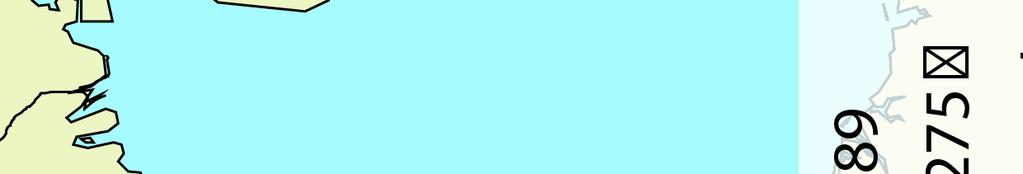
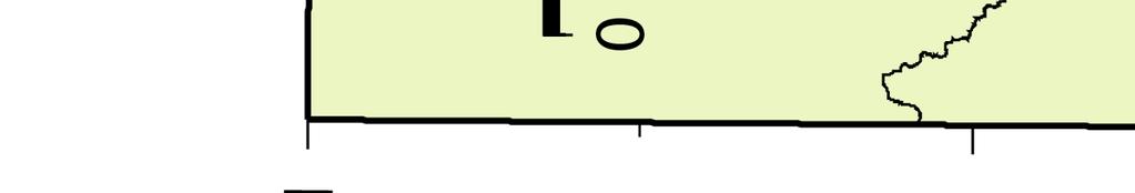
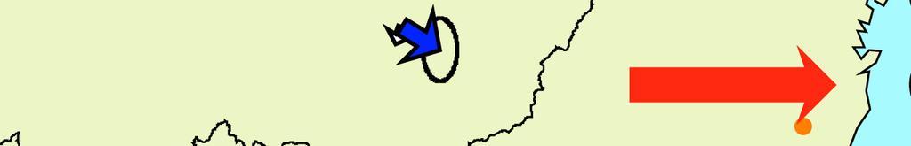
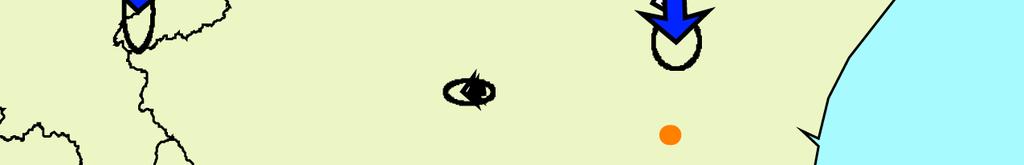
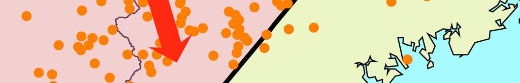
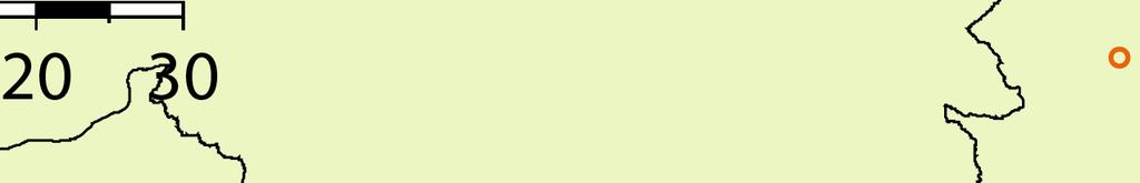
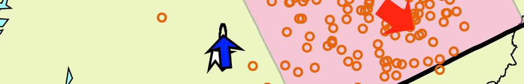
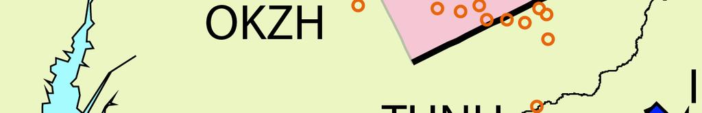
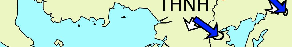
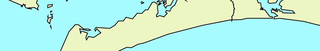
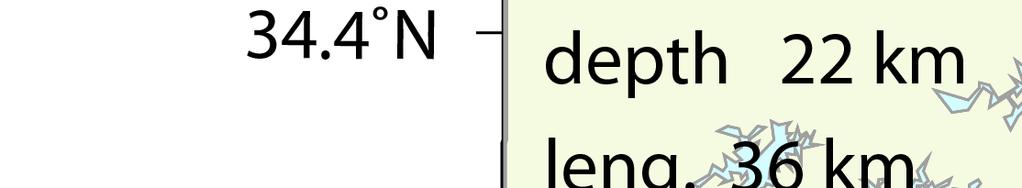
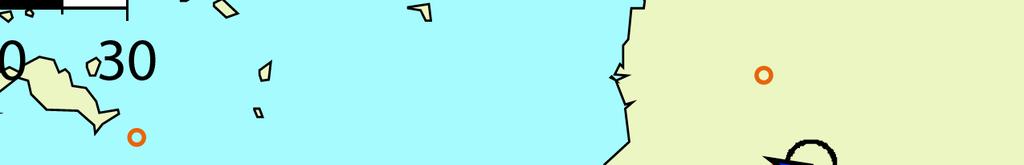
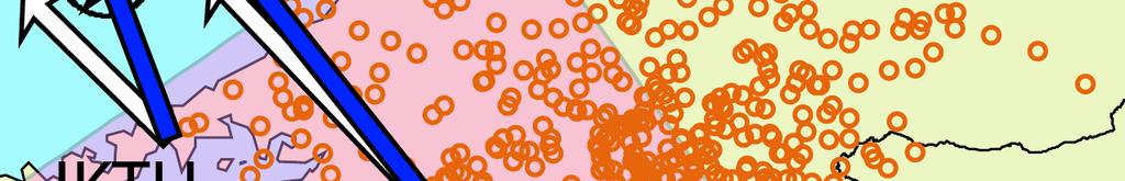
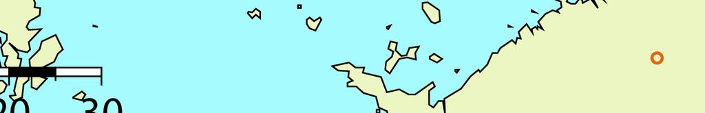
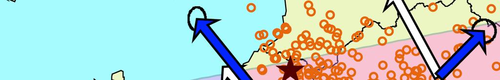
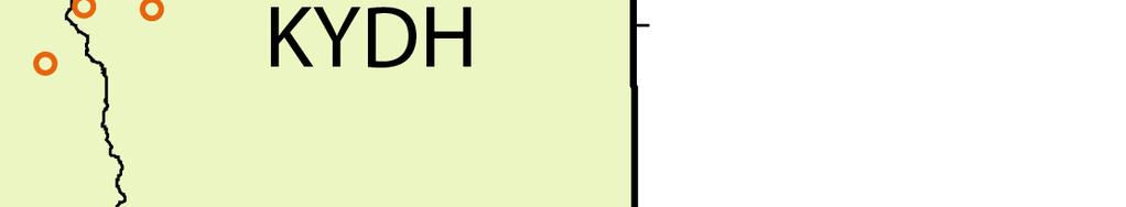
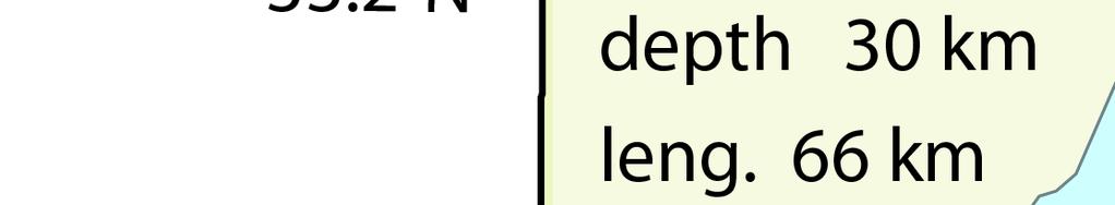
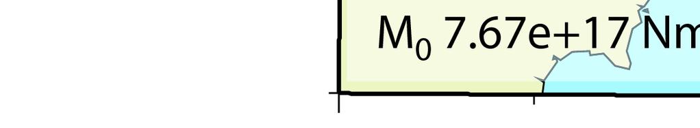
1 9-2 西南日本における短期的スロースリップイベント (2008 年 5 月 ~2008 年 10 月 ) Short-term slow slip events with non-volcanic tremors in southwest Japan (May - October, 2008) 防災科学技術研究所 National Research Institute for Earth Science and Disaster Prevention 2008 年 5 月から 10 月にかけて西南日本の深部低周波微動 1) に同期して発生した短期 的スロースリップイベント 2,3) (SSE) について報告する. (1) 5 月中旬愛知県中部 5 月 14 日から 17 日にかけて, 愛知県中部の観測点において, 深部低周波微動と同期した SSE による傾斜変化がとらえられた ( 第 1 図 ). この 4 日間の傾斜変化ベクトル, そのデータから推定された SSE の矩形断層モデル, およびそのモデルから計算される傾斜変化ベクトルを第 2 図に示した. 推定された断層モデルは, この期間に発生した微動および超低周波地震 5) (VLFE) の震央位置と重なる. ただし観測された傾斜変化は最大でも 0.05μ rad 程度と非常に小さく, 推定された断層パラメタの信頼性はあまり高くないと考えられる. (2) 6 月中旬三重県 6 月 15 日から 19 日にかけて, 三重県中部を中心とする観測点において深部低周波微動と同期した SSE による傾斜変化がとらえられた ( 第 3 図 ). この 5 日間の傾斜変化から推定された SSE の矩形断層モデルを第 4 図に示す.2008 年 3 月にもこの地域で SSE が発生しているが 6), ちょうど今回の活動領域の北隣にあたる. ほぼ同様な領域での活動は 2007 年 11 月以来である 6). (3) 8-9 月愛知県東部 8 月下旬から 9 月上旬の期間に, 長野県南部から愛知県東部にかけて移動する微動活動が発生した 1). このなかで愛知県東部の活動に対応する SSE による傾斜変化が 8 月 31 日から 9 月 4 日にかけてとらえられた ( 第 5 図 ). 変動量が小さいので解の精度はあまり高くないと考えられるが, おおよそ微動の震央位置と調和的な位置の SSE で, 観測された傾斜変動を説明できる ( 第 6 図 ). (4) 9-10 月四国西部 9 月下旬から 10 月上旬の豊後水道から四国西部域にかけての微動活動 1) に同期し,9 月 27 日から 10 月 3 日の期間に四国西部の観測点において明瞭な傾斜変化がとらえられた ( 第 7 図 ). その最大変化量は観測点 UWAH で 0.2μrad という大きなものだった. これらの傾斜変化データから推定された SSE の断層モデルを第 8 図に示す. 観測された傾斜変化は,
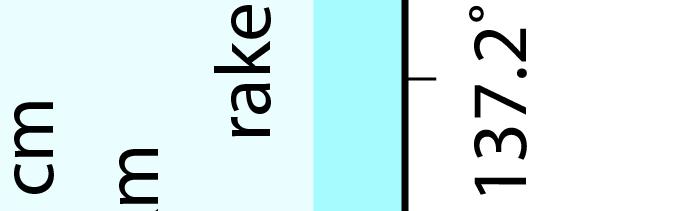
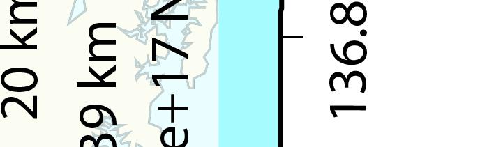
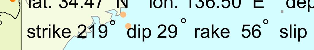
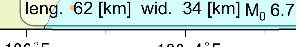
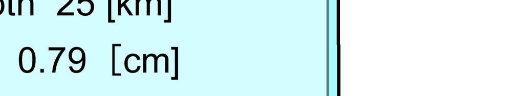
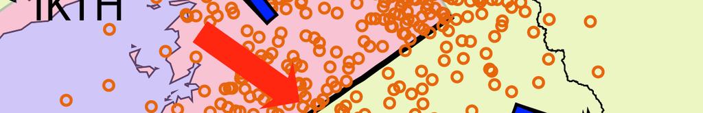
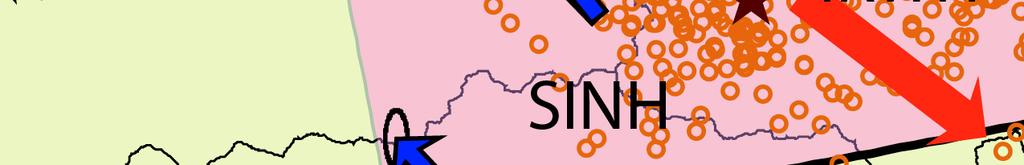
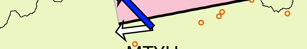
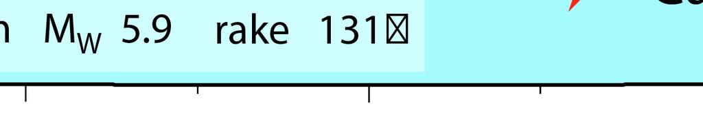
2 微動活動 VLFE 分布をおおよそカバーする領域の SSE で説明できる. このイベントは今回報告する他のイベントに比べて傾斜変動量が大きく, また傾斜変動の立ち上がりの時刻が各観測点で変化しているので, それらの記録を使ってすべりの時間発展を推定することを試みた. プレート境界面を小断層に分割し, そこでのすべりの時空間変化を傾斜データから求めた. 第 9 図にすべり速度分布のスナップショットを示す. すべり領域と微動の震央が同時に南西から北東方向へ移動していく様子が見られる. 最大すべり速度は 3.2 m/yr (~1.0e-7 m/s). 第 10 図にこの SSE のすべり分布を示す.UWAH 付近を中心とする 最大 5.6 cm のすべりが得られた.Mw=6.2. モーメントレート関数と微動活動の対比を第 11 図に示す. モーメント解放レートと微動活動度が良い対応を示している. 第 12 図に示すように, ここで推定されたすべり過程から計算される傾斜変化は観測データの特徴を良く説明している. 観測点 TBEH で 10 月 1 日頃に見られる比較的速い変化はモデルでは再現されていないが, この変化は同時期に見られる気圧変化もしくは降雨の影響が疑われる. (5) 10 月四国東部 (4) で述べた四国西部の活動に引き続き,10 月中旬に四国東部で微動活動と SSE に伴う傾斜変動が観測された. 第 13 図に示すように,10 月 13 日から 16 日にかけて四国東部の複数の観測点で傾斜変化が見られた ( 最大は SINH の 0.1μrad). この 4 日間の傾斜変化量から推定した SSE の断層モデルを第 14 図に示す. 微動 VLFE の分布と調和的な位置にすべりが推定された. 謝辞気象庁のホームページで公開されている気象台等の気象観測データを使用させていただきました. 記して感謝いたします. ( 廣瀬仁 関根秀太郎 小原一成 ) 参考文献 1) 防災科学技術研究所, 西南日本における深部低周波微動活動 (2008 年 5 月 年 10 月 ), 本会報. 2) Obara, K., H. Hirose, F. Yamamizu, and K. Kasahara, Episodic slow slip events accompanied by non-volcanic tremors in southwest Japan subduction zone, Geophys. Res. Lett., 31 (23), doi: /2004gl020848, ) Hirose, H. and K. Obara, Repeating short- and long-term slow slip events with deep tremor activity around the Bungo channel region, southwest Japan, Earth Planets
3 Space, 57 (10), , ) Tamura, Y., T. Sato, M. Ooe, M. Ishiguro, A procedure for tidal analysis with a Bayesian information criterion, Geophys. J. Int., 104, , ) Ito, Y., K. Obara, K. Shiomi, S. Sekine, and H. Hirose, Slow Earthquakes Coincident with Episodic Tremors and Slow Slip Events, Science, 315, , ) 防災科学技術研究所, 西南日本における短期的スロースリップイベント (2007 年 11 月 年 3 月 ), 連絡会報, 80, , 2008.
 SSE")


 and")

")


 for the")


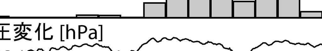
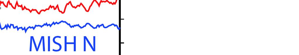
4 SSE ( ) SSE ( ) ( )., VLFE. Fig. 2 Observed tilt change vectors for four days from May 14, 2008 (blue arrows), the estimated fault slip (a red arrow) and rectangular fault location and geometry (a pink rectangle) based on the tilt change vectors, and the calculated tilt changes due to the fault model (open arrows) for the May 2008 SSE in the central part of Aichi area, Tokai. Orange dots and stars show epicenters of the tremor activity and VLFEs occurred in this time period, respectively BAYTAP-G 4). SSE.. Fig. 1 Time series of tiltmeter records, daily tremor counts, atmospheric pressure change and daily precipitation in Aichi area, Tokai, from April 28 to May 21, `N' and `E' that follow a four-character station code denote the northward and eastward ground down tilt components, respectively. The tilt changes for the time window indicated by broken lines are assumed to be caused by an SSE. The atmospheric pressure and precipitation were observed at the JMA Nagoya meteorological observatory. The tilt records after removing tidal components and atmospheric pressure response estimated with BAYTAP-G are shown.


5 SSE Fig. 4 Same as Fig. 2 but for the June 2008 Mie prefecture short-term SSE Fig. 3 Same as Fig. 1 but for the records observed around the northern Kii peninsula from June 1 to 23, The atmospheric pressure and the precipitation were observed at the JMA Tsu meteorological observatory. The station locations and the tilt changes during the time window indicated by broken lines are shown in Fig. 4.


6 SSE Fig. 6 Same as Fig. 2 but for the August-September 2008 SSE around the eastern Aichi area Fig. 5 Same as Fig. 1 but for the records observed around the eastern Aichi area from August 10 to September 7, The atmospheric pressure and precipitation were observed at the JMA Nagoya meteorological observatory.


7 SSE Fig. 8 Same as Fig. 2 but for the September-October 2008 western Shikoku SSE Fig. 7 Same as Fig. 1 but for the records observed around the western Shikoku area from September 10 to October 4, The atmospheric pressure and precipitation were observed at the JMA Uwajima meteorological observatory.


8 Sep 26 00:00 Sep 27 00:00 Sep 28 00:00 Sep 29 00:00 Sep 30 00:00 Oct 01 00:00 Oct 02 00:00 Oct 03 00:00 Oct 04 00:00 Oct 05 00: Slip Rate (m/yr) SSE. (1 ).. Fig. 9 Daily snapshots of slip rate distributions for the September-October 2008 western Shikoku short-term SSE. Time epochs are displayed on the top of each frame. Orange dots show tremor epicenters SSE. Fig. 10 Cumulative slip distribution of the September-October 2008 western Shikoku short-term SSE. Orange dots show tremor epicenters.
 6")

 with 1")
")

 of the")


9 SSE (, ; 1 ) 6 (, ). Fig. 11 Moment rate function (solid curve) with 1 error range (dotted curves) and the number of tremors for every six hours (bars) of the September-October 2008 western Shikoku short-term SSE SSE ( ) ( ). Fig. 12 Observed (red and blue curves) and computed tilt records (broken curves) for the September-October 2008 western Shikoku short-term SSE.


10 SSE Fig. 14 Same as Fig. 2 but for the October 2008 eastern Shikoku short-term SSE Fig. 13 Same as Fig. 1 but for the records observed in the eastern Shikoku area from October 6 to 20, The atmospheric pressure and precipitation were observed at the JMA Kochi meteorological observatory.
西南日本における短期的スロースリップイベント (2011 年11 月~2012 年4 月)
") 9-2 西南日本における短期的スロースリップイベント (2011 年 11 月 ~2012 年 4 月 ) Short-term slow slip events with non-volcanic tremor in southwest Japan (November, 2011-April, 2012) 防災科学技術研究所 National Research Institute for Earth
9-2 西南日本における短期的スロースリップイベント (2011 年 11 月 ~2012 年 4 月 ) Short-term slow slip events with non-volcanic tremor in southwest Japan (November, 2011-April, 2012) 防災科学技術研究所 National Research Institute for Earth
紀伊半島~四国の歪・傾斜・地下水観測結果(2017年5月~2017年10月)
") 8-7 紀伊半島 ~ 四国の歪 傾斜 地下水観測結果 (2017 年 5 月 ~ The variation of the strain, tilt and groundwater level in the Shikoku District and Kii Peninsula, Japan (from May 2017 to October 2017) 産業技術総合研究所 Geological Survey
8-7 紀伊半島 ~ 四国の歪 傾斜 地下水観測結果 (2017 年 5 月 ~ The variation of the strain, tilt and groundwater level in the Shikoku District and Kii Peninsula, Japan (from May 2017 to October 2017) 産業技術総合研究所 Geological Survey
紀伊半島~四国の歪・傾斜・地下水観測結果(2012年5月~2012年10月)
") 8-6 紀伊半島 ~ 四国の歪 傾斜 地下水観測結果 (2012 年 5 月 ~2012 年 10 月 ) The variation of the strain, tilt and groundwater level in the Shikoku District and Kii Peninsula, Japan (from May 2012 to October 2012) 産業技術総合研究所
8-6 紀伊半島 ~ 四国の歪 傾斜 地下水観測結果 (2012 年 5 月 ~2012 年 10 月 ) The variation of the strain, tilt and groundwater level in the Shikoku District and Kii Peninsula, Japan (from May 2012 to October 2012) 産業技術総合研究所
 紀伊半島 ~ 愛知県における歪 傾斜 地下水観測結果 (2012 年 9 月 ~11 月 ) 産業技術総合研究所 産業技術総合研究所 ( 産総研 ) の紀伊半島 ~ 愛知県の10 観測点 ( 図 1) における2012 年 9 月 1 日から11 月 15 日までの歪 傾斜 地下水および気象観測結果を図 2~19に示す. また, 産総研がエンベロープ相関法を用いて決定した, 深部低周波微動の震源時空間分布および個数を図
 紀伊半島 ~ 愛知県における歪 傾斜 地下水観測結果 (2013 年 9 月 ~11 月 ) 産業技術総合研究所 産業技術総合研究所 ( 産総研 ) の紀伊半島 ~ 愛知県の10 観測点 ( 図 1) における2013 年 9 月 1 日から11 月 14 日までの歪 傾斜 地下水および気象観測結果を図 2~19に示す. また, 産総研がエンベロープ相関法を用いて決定した, 深部低周波微動の震源時空間分布および個数を図
Time Variation of Earthquake Volume and Energy-Density with Special Reference to Tohnankai and Mikawa Earthquake Akira IKAMi and Kumizi IIDA Departmen
 Time Variation of Earthquake Volume and Energy-Density with Special Reference to Tohnankai and Mikawa Earthquake Akira IKAMi and Kumizi IIDA Department of Earth Sciences, Nagoya University (Received January
京都大学防災研究所年報第 60 号 A 平成 29 年 DPRI Annuals, No. 60 A, 2017 Generating Process of the 2016 Kumamoto Earthquake Yoshihisa IIO Synopsis The 2016 Kumamoto e
 京都大学防災研究所年報第 60 号 A 平成 29 年 DPRI Annuals, No. 60 A, 2017 Generating Process of the 2016 Kumamoto Earthquake Yoshihisa IIO Synopsis The 2016 Kumamoto earthquake is a large intraplate earthquake that broke
7-1 2007年新潟県中越沖地震(M6.8)の予測について
の予測について") M. On Forecast of the Niigata Chuetsu-oki Earthquake (M. Kiyoo Mogi (M. ) M. (Mogi, ) M. M. - 327 - (M. ) M. M AB CD (a) AB A B (b) C D M M. M - - 328 - M. (M. ) (M. ) (Ohta et al., ) (Mogi, ) L M Log
M. On Forecast of the Niigata Chuetsu-oki Earthquake (M. Kiyoo Mogi (M. ) M. (Mogi, ) M. M. - 327 - (M. ) M. M AB CD (a) AB A B (b) C D M M. M - - 328 - M. (M. ) (M. ) (Ohta et al., ) (Mogi, ) L M Log
倉田.indd
 LAGUNA 33 6 7 LAGUNA p.33 6 7 Rising water level events in the Ohashi River, Shimane Prefecture. Kengo Kurata Abstract: Several periods of water level rise in the Ohashi River, Shimane Prefecture were
8km M km M M8.4 1M M M 東北地方太平洋沖で想定されていた地震 Fig % 8 9% M8. 6 3m M % Fig.1 Distribution of
 東日本大震災 A Catastrophic Earthquake in Tohoku, Japan 1) 東北地方太平洋沖地震の地震 地震動について 1) Earthquake and Strong Ground Motion of the 211 off the Pacific Coast of Tohoku Earthquake 小林喜久二 Kikuji Kobayashi *1 211 3 11
紀伊半島~四国の歪・傾斜・地下水観測結果(2012年11月~2013年4月)
") 8 9 紀伊半島 四国の歪 傾斜 地下水観測結果 2012 年 11 月 2013 年 4 月 The variation of the strain, tilt and groundwater level in the Shikoku District and Kii Peninsula, Japan (from November 2012 to April 2013) 産業技術総合研究所 Geological
8 9 紀伊半島 四国の歪 傾斜 地下水観測結果 2012 年 11 月 2013 年 4 月 The variation of the strain, tilt and groundwater level in the Shikoku District and Kii Peninsula, Japan (from November 2012 to April 2013) 産業技術総合研究所 Geological
2008年1月11日に岩手県釜石沖で発生した地震(M4.7)について
について") 3-2 2008 年 1 月 11 日に岩手県釜石沖で発生した地震 (M4.7) について On the M4.7 earthquake off Kamaishi, Iwate prefecture, Japan, on January 11, 2008. 東北大学大学院理学研究科 Graduate School of Science, Tohoku University 2008 年 1 月 11
3-2 2008 年 1 月 11 日に岩手県釜石沖で発生した地震 (M4.7) について On the M4.7 earthquake off Kamaishi, Iwate prefecture, Japan, on January 11, 2008. 東北大学大学院理学研究科 Graduate School of Science, Tohoku University 2008 年 1 月 11
* Meso- -scale Features of the Tokai Heavy Rainfall in September 2000 Shin-ichi SUZUKI Disaster Prevention Research Group, National R
 38 2002 7 2000 9 * Meso- -scale Features of the Tokai Heavy Rainfall in September 2000 Shin-ichi SUZUKI Disaster Prevention Research Group, National Research Institute for Earth Science and Disaster Prevention,
スライド 1
 The 6th Joint Meeting of the UJNR Panel on Earthquake Research, 2006/11/9-10 Kazushige Obara,Yoshihiro Ito, Shutaro Sekine, Hitoshi Hirose and Katsuhiko Shiomi NIED) Deep slow earthquake families in the
 Clustering in Time and Periodicity of Strong Earthquakes in Tokyo Masami OKADA Kobe Marine Observatory (Received on March 30, 1977) The clustering in time and periodicity of earthquake occurrence are investigated
3 - 7 松代アレイ震源による長野県北部の地震活動の特徴: 時空間変化
 3-7 松代アレイ震源による長野県北部の地震活動の特徴 : 時空間変化 Monitoring of Space-time Variations of Earthquake Occurrence in the Northern Part of Nagano Prefecture by the Matsushiro Seismic Array System 気象庁地震観測所 Seismological
untitled
 20 * Re-Evaluation of Isoseismal Maps and Magnitudes from Two Big Earthquakes along the Subduction Zone of Kyushu and Ryukyu Islands Early in the 20th Century Masayuki TAKEMURA, Katsuhisa KANDA Kobori
8-2 近畿・四国地方の地殻変動
 Crustal Movements in Kinki and Shikoku Districts Geographical Survey Institute 122311241 222311-1 2 34 BM9189 12 4BM4772 251-2 5 2495 6 251 7 51635121 8 91219 1 1118 12112 13GEONET1622 249241264-496 -
神奈川県西部山北南高感度地震観測井の掘削および孔内検層,Borehole Drilling and Physical Properties of the Yamakita-minami Seismic Observatory in Western Ka
 *1 *2 *3 *4 *5 *5 *6 *6 *2 *7 *5 *4 *5 *5 *6 *6 Borehole Drilling and Physical Properties of the Yamakita-minami Seismic Observatory in Western Kanagawa Prefecture, Central Honshu, Japan Hiroki HAYASHI
2 SSE 1 GEONET 26 Hi-net 4 BAYTAP-G (Tamura et al., 1991) GEONET (F3) (, 29) 935 ( ) SSE SSE Hi-net (Obara et al., 25) SSE SSE KT2H ( ) CBAH
 GEONET (F3) (, 29) 935 ( ) SSE SSE Hi-net (Obara et al., 25) SSE SSE KT2H ( ) CBAH") 神 戸 大 学 都 市 安 全 研 究 センター 研 究 報 告, 第 19 号, 平 成 27 年 3 月 27 211 : The 27 and 211 Boso slow slip events: a driving process for the accompanying earthquake swarm 1) Hitoshi Hirose 2) Takanori Matsuzawa 3)
神 戸 大 学 都 市 安 全 研 究 センター 研 究 報 告, 第 19 号, 平 成 27 年 3 月 27 211 : The 27 and 211 Boso slow slip events: a driving process for the accompanying earthquake swarm 1) Hitoshi Hirose 2) Takanori Matsuzawa 3)
東海・紀伊半島・四国における短期的スロースリップイベント(2012年11月~2013年4月)
") 6- 東海 紀伊半島 四国における短期的スロースリップイベント ( 年 月 年 4 月 ) Short-term slow slip events in the Tokai area, the Kii Peninsula and the Shikoku District, Japan (from November to April ) 産業技術総合研究所 Geological Survey of Japan,
6- 東海 紀伊半島 四国における短期的スロースリップイベント ( 年 月 年 4 月 ) Short-term slow slip events in the Tokai area, the Kii Peninsula and the Shikoku District, Japan (from November to April ) 産業技術総合研究所 Geological Survey of Japan,
0-
 5 6 7 Seismic observation station Agency Seismic intensity South- North (NS) Maximum acceleration (Gal ) East-West (EW) Vertical (UD) Combining threecomponent Epicentral distance (km) Kawaguchi* JMA 7
7-3 2004年新潟県中越地震
 04 Mid Niigata earthquake Earthquake Research Institute, University of Tokyo. 04 23 17 6 M6.8 7 18 12 M6.018 34 M6. 6 27 40 M6.1 11 8 11 1 M.9 30km M6 1 14 1) 2 RMS P 0.17 0.074 S 0.476 0.166 900 P 3 S
mm mm , ,000 Fig. 1 Locality map of the investigation area NE SW Fi
 5 Report on the Landslide Disaster in the Upper Part of the Abukuma River, Fukushima Prefecture, Due to Heavy Rainfall in August 1998 By Takashi INOKUCHI National Research Institute for Earth Science and
研究成果報告書
 General study on the eruption at Shinmoedake volcano, Kirishima, in 2011 24 6 11 A magmatic eruption event took place at Shinmoedake (Kirishima) Volcano in January 2011, leaving about 300 years of hiatus.
1793 Detailed Distributions of Seismic Intensity and Tsunami Heights of the Kansei off Miyagi Prefecture Earthquake of February 17, 1793 Yuichi NAMEGA
 1793 Detailed Distributions of Seismic Intensity and Tsunami Heights of the Kansei off Miyagi Prefecture Earthquake of February 17, 1793 Yuichi NAMEGAYA, Yoshinobu TSUJI, Kazue UEDA Earthquake Research
Fig. 1. Horizontal displacement of the second and third order triangulation points accompanied with the Tottori Earthquake of (after SATO, 1973)
") Journal of the Geodetic Society of Japan Vol. 27, No. 3, (1981), pp. 183-191 Research on Fault Movement by means of Aero-Triangulation ( T) (An experiment on the earthquake fault of the Izu-Oshima Kinkai
Journal of the Geodetic Society of Japan Vol. 27, No. 3, (1981), pp. 183-191 Research on Fault Movement by means of Aero-Triangulation ( T) (An experiment on the earthquake fault of the Izu-Oshima Kinkai
On the Detectability of Earthquakes and Crustal Movements in and around the Tohoku District (Northeastern Honshu) (I) Microearthquakes Hiroshi Ismi an
 (I) Microearthquakes Hiroshi Ismi an") On the Detectability of Earthquakes and Crustal Movements in and around the Tohoku District (Northeastern Honshu) (I) Microearthquakes Hiroshi Ismi and Akio TAKAGI Observation Center for Earthquake Prediction,
On the Detectability of Earthquakes and Crustal Movements in and around the Tohoku District (Northeastern Honshu) (I) Microearthquakes Hiroshi Ismi and Akio TAKAGI Observation Center for Earthquake Prediction,
untitled
 Annuals of Disas. Prev. Res. Inst., Kyoto Univ., No. 48 A, 2005 1. 2004 26 9 4,000m 28 8.7 2. 2004 12 26 M9.0 6cm ( 1,600km) ( 6,000km) 1900 Table 23 2 150 60 2 22 7 72 7,530 11 (1) 1755 62,000 (2) 1782
Microsoft Word - mitomi_v06.doc
 MSS mitomi@edm.bosai.go.jp matsuoka@edm.bosai.go.jp yamazaki@edm.bosai.go.jp taniguchi@manage.nitech.ac.jp 1 MSS MSS 2 2 1 m MSS CCT CCT Fig.1 CCT b02-b0 b0-b0b-b b-b1 CCT Landsat/TM MSS S/N 21x21 21x21
 Azusa NISHIZAWA, Tomozo ONO, Noboru SASAHARA, Hiroshi HASHIGUCHI and Yasuo OTANI Shikoku Basin Ridge Myojin-sho Shichito- Iwo-jima Ogasawara Trough Ogasawara Ridge Izu-Ogasawara Trench Kaitoku Smt. Pacific
8-5 中国・四国・九州地方の地殻変動
 Crustal Movements in the Chugoku, Shikoku and Kyushu Districts Geographical Survey Institute 1 -(1) (9)GPS 2000 10 6 (Mj7.3) 2 co-seismic 2001 2 2 2000 10 6 310 4 -(1) (6) 5 -(1) (3) 2001 GPS 6 7 GPS 2001
ñ{ï 01-65
 191252005.2 19 *1 *2 *3 19562000 45 10 10 Abstract A review of annual change in leading rice varieties for the 45 years between 1956 and 2000 in Japan yielded 10 leading varieties of non-glutinous lowland
 REPORT OF HYDROGRAPHIC AND OCEANOGRAPHIC RESEARCHES JAPAN COAST GUARD TOKYO, JAPAN Older issues http://www1.kaiho.mlit.go.jp/kikaku/kenkyu/liste.html Azusa NISHIZAWA, Tomozo ONO, Noboru SASAHARA, Hiroshi
1 May 2011
 1 May 2011 2 May 2011 3 May 2011 4 May 2011 5 June 2011 6 June 2011 7 June 2011 8 June 2011 9 July 2011 10 July 2011 11 July 2011 12 July 2011 13 August 2011 14 August 2011 15 August 2011 16 August 2011
東海・南関東地域におけるひずみ観測結果(2013年5月~10月)
") 6-3 東海 南関東地域におけるひずみ観測結果 (2013 年 5 月 ~10 月 ) Observation of Crustal Strain by Borehole Strainmeters in the Tokai and Southern Kanto Districts (May October 2013) 気象庁 Japan Meteorological Agency 第 1 図は, 東海から南関東地域における埋込式体積ひずみ計
6-3 東海 南関東地域におけるひずみ観測結果 (2013 年 5 月 ~10 月 ) Observation of Crustal Strain by Borehole Strainmeters in the Tokai and Southern Kanto Districts (May October 2013) 気象庁 Japan Meteorological Agency 第 1 図は, 東海から南関東地域における埋込式体積ひずみ計
1.7 D D 2 100m 10 9 ev f(x) xf(x) = c(s)x (s 1) (x + 1) (s 4.5) (1) s age parameter x f(x) ev 10 9 ev 2
 xf(x) = c(s)x (s 1) (x + 1) (s 4.5) (1) s age parameter x f(x) ev 10 9 ev 2") 2005 1 3 5.0 10 15 7.5 10 15 ev 300 12 40 Mrk421 Mrk421 1 3.7 4 20 [1] Grassberger-Procaccia [2] Wolf [3] 11 11 11 11 300 289 11 11 1 1.7 D D 2 100m 10 9 ev f(x) xf(x) = c(s)x (s 1) (x + 1) (s 4.5) (1)
2005 1 3 5.0 10 15 7.5 10 15 ev 300 12 40 Mrk421 Mrk421 1 3.7 4 20 [1] Grassberger-Procaccia [2] Wolf [3] 11 11 11 11 300 289 11 11 1 1.7 D D 2 100m 10 9 ev f(x) xf(x) = c(s)x (s 1) (x + 1) (s 4.5) (1)
2016 年熊本地震の余震の確率予測 Probability aftershock forecasting of the M6.5 and M7.3 Kumamoto earthquakes of 2016 東京大学生産技術研究所統計数理研究所東京大学地震研究所 Institute of Indus
 2016 年熊本地震の余震の確率予測 Probability aftershock forecasting of the M6.5 and M7.3 Kumamoto earthquakes of 2016 東京大学生産技術研究所統計数理研究所東京大学地震研究所 Institute of Industrial Science, University of Tokyo The Institute of
GMT v3.4.6 Document from psxy
 平成 年 月 日気象庁地震火山部 最近の東海地域とその周辺の地殻活動 現在のところ 東海地震に直ちに結びつくとみられる変化は観測していません. 地震の観測状況 月 日から 日 及び 日から 日にかけて 愛知県のプレート境界付近を震源とする深部低周波地震 ( 微動 ) を観測しています また 月 日以降 長野県のプレート境界付近を震源とする深部低周波地震 ( 微動 ) を観測しています. 地殻変動の観測状況
Detailed Spatial Distributions of Foreshock and Aftershock Activities of Small Earthquakes Kiyoshi ITO and Akio KUROISO Abuyama Seismological Observat
 Detailed Spatial Distributions of Foreshock and Aftershock Activities of Small Earthquakes Kiyoshi ITO and Akio KUROISO Abuyama Seismological Observatory, Fuculty of Science, Kyoto University (Received
LAGUNA LAGUNA 10 p Water quality of Lake Kamo, Sado Island, northeast Japan, Katsuaki Kanzo 1, Ni
 LAGUNA10 47 56 2003 3 LAGUNA 10 p.47 56 2003 1997 2001 1 2 2 Water quality of Lake Kamo, Sado Island, northeast Japan, 1997 2001 Katsuaki Kanzo 1, Niigata Prefectural Ryotsu High School Science Club, Iwao
火山噴火予知連絡会会報第 129 号 防災科学技術研究所の基盤的火山観測網で観測された * 草津白根山 2018 年 1 月 23 日噴火に伴う広帯域地震記録 Characteristics of broadband seismic record accompanying the eruption
 防災科学技術研究所の基盤的火山観測網で観測された * 2018 年 1 月 23 日噴火に伴う広帯域地震記録 Characteristics of broadband seismic record accompanying the eruption at Kusatsu-Shirane volcano on 23 January, 2018, observed by the V-net of the
 November 13 June 1 April 23 October 1 December 22 August 6 September 5 July 2 May 2 8 6 11 1 7 01 1516 4 23 4 1995 4 23 1999 4 23 19 2 02 88 5 2 3 03 6 1 6 1 300 4 04 100 7 2 7 2 706 15 2 5 05 8 6 86
12-9 地震活動の再現と固有地震
 12-9 地震活動の再現と固有地震 Reappearance of Similar Seismicity Pattern preceding Characteristic Earthquakes 防災科学技術研究所松村正三 National Research Institute for Earth Science and Disaster Prevention 1. 茨城県沖の地震活動プレート境界固有地震の発生前には,
untitled
 48 B 17 4 Annuals of Disas. Prev. Res. Inst., Kyoto Univ., No. 48 B, 2005 (CO 2 ) (2003) Sim-CYCLE(Ito and Oikawa, 2000) CO 2 CO 2 Figure 1 CO 2 0 (Denning et al., 1995) CO 2 (2004) Sim-CYCLE CO 2 CO 2
Corrections of the Results of Airborne Monitoring Surveys by MEXT and Ibaraki Prefecture
 August 31, 2011 Corrections of the Results of Airborne Monitoring Surveys by MEXT and Ibaraki Prefecture The results of airborne monitoring survey by MEXT and Ibaraki prefecture released on August 30 contained
Fig. 1. Active faults in the Kanto district (after Coordinating Committee for Earthquake Prediction, 1980). A-A' PROFILE DOUGUER ANOMALY RESIDUAL ANOM
. A-A' PROFILE DOUGUER ANOMALY RESIDUAL ANOM") Structure of the Basement and the Gravity Anomaly in the Kanto Plain -A Geophysical Study of Active Fault- Takashi TADA Crustal Dynamics Department, Geographical Survey Institute (Received Apirl 7, 1983)
Structure of the Basement and the Gravity Anomaly in the Kanto Plain -A Geophysical Study of Active Fault- Takashi TADA Crustal Dynamics Department, Geographical Survey Institute (Received Apirl 7, 1983)
 SEISMIC HAZARD ESTIMATION BASED ON ACTIVE FAULT DATA AND HISTORICAL EARTHQUAKE DATA By Hiroyuki KAMEDA and Toshihiko OKUMURA A method is presented for using historical earthquake data and active fault
/ / M. km km. m 図 1 CMT Hi-net CMT F-net CMT 図 1 PGV K-NET KiK-net 2. 地震および地震動の概要 / M JMA. / M JMA. 図 1 CMT PGV
 J. JSNDS 35-2 77-86 2016 平成 28 年 (2016 年 ) 熊本地震の概要と益城町周辺における余震 常時微動観測 宮本崇 1 飯山かほり 2 後藤浩之 3 盛川仁 2 Summary of the Kumamoto Earthquake and aftershock/microtremer observations in and around Mashiki town Takashi


Fig. 1. Restored map of the study area and its environs, eliminating valleys less than 500 m across. Squares show the area where following maps are av
 Damage by 1799 Kanazawa Earthquake in Relation to Fault Movement Akira SANGAWA Geological Survey of Japan (Received October 18, 1986) In the evening of June 29, 1799, a strong earthquake occurred in an
Studies of Foot Form for Footwear Design (Part 9) : Characteristics of the Foot Form of Young and Elder Women Based on their Sizes of Ball Joint Girth
 : Characteristics of the Foot Form of Young and Elder Women Based on their Sizes of Ball Joint Girth") Studies of Foot Form for Footwear Design (Part 9) : Characteristics of the Foot Form of Young and Elder Women Based on their Sizes of Ball Joint Girth and Foot Breadth Akiko Yamamoto Fukuoka Women's University,
Studies of Foot Form for Footwear Design (Part 9) : Characteristics of the Foot Form of Young and Elder Women Based on their Sizes of Ball Joint Girth and Foot Breadth Akiko Yamamoto Fukuoka Women's University,
IR0036_62-3.indb
 62 3 2016 253 272 1921 25 : 27 8 19 : 28 6 3 1921 25 1921 25 1952 27 1954 291960 35 1921 25 Ⅰ 0 5 1 5 10 14 21 25 34 36 59 61 6 8 9 11 12 16 1921 25 4 8 1 5 254 62 3 2016 1 1938.8 1926 30 1938.6.23 1939.9
Microsoft Word - 223回予知連表紙.doc
 資料 8 第 2 2 3 回 地震予知連絡会資料 2019 年 5 月 22 日 京都大学防災研究所 第 223 回地震予知連絡会提出資料 目 次 Ⅰ. 日向灘の地殻活動等 (3c) 1. 日向灘の地震 (2019 年 5 月 10 日,Mj = 6.3) について 1 2.GNSS 観測による日向灘の地震 (M6.3) の地殻変動 4 3.ETAS モデルを用いた南海トラフ 日向灘における地震活動の異常性の評価
X X 1. 1 X 2 X 195 3, 4 Ungár modified Williamson-Hall/Warren-Averbach 5-7 modified modified Rietveld Convolutional Multiple Whole Profile CMWP 8 CMWP
 X X a a b b c Characterization of dislocation evolution during work hardening of stainless steels by using XRD line-profile analysis Tomoaki KATO a, Shigeo SATO a, Yoichi SAITO b, Hidekazu TODOROKI b and
75 unit: mm Fig. Structure of model three-phase stacked transformer cores (a) Alternate-lap joint (b) Step-lap joint 3 4)
 Alternate-lap joint (b) Step-lap joint 3 4)") 3 * 35 (3), 7 Analysis of Local Magnetic Properties and Acoustic Noise in Three-Phase Stacked Transformer Core Model Masayoshi Ishida Kenichi Sadahiro Seiji Okabe 3.7 T 5 Hz..4 3 Synopsis: Methods of local
3 * 35 (3), 7 Analysis of Local Magnetic Properties and Acoustic Noise in Three-Phase Stacked Transformer Core Model Masayoshi Ishida Kenichi Sadahiro Seiji Okabe 3.7 T 5 Hz..4 3 Synopsis: Methods of local
2013 910 September / October NAGOYA Cultural Information 02 NAGOYA Cultural Information No.352 Contents 2 3 4 6 10 11 12
 2013 910 September October No.352 NAGOYA Cultural Information 2013 910 September / October NAGOYA Cultural Information 02 NAGOYA Cultural Information No.352 Contents 2 3 4 6 10 11 12 NAGOYA Cultural Information
草津白根山における地磁気全磁力・自然電位観測
 1 2 1 1 1 3 1 1 1 1 1 2 3 Observation of Geomagnetic Total Force and Self-potential at Kusatsu-Shirane Volcano T.Koike 1 I.Suganuma 2 T.Uesugi 1 I.Fujii 1 H.Takahashi 1 K.Ikeda 3 N.Kumasaka 1 T.Ookawa
untitled
 * Coseismic and postseismic coastal environment changes caused by the 1703 Genroku Kanto Earthquake in the southern part of Boso Peninsula, central Japan Jun Muragishi Graduate School of Urban Environmental
Fig. 3 Flow diagram of image processing. Black rectangle in the photo indicates the processing area (128 x 32 pixels).
.") Fig. 1 The scheme of glottal area as a function of time Fig. 3 Flow diagram of image processing. Black rectangle in the photo indicates the processing area (128 x 32 pixels). Fig, 4 Parametric representation
Fig. 1 The scheme of glottal area as a function of time Fig. 3 Flow diagram of image processing. Black rectangle in the photo indicates the processing area (128 x 32 pixels). Fig, 4 Parametric representation
2-1 東北地方およびその周辺の微小地震活動(1984年11月~1985年4月)
") 2-1 東北地方およびその周辺の微小地震活動 (1984 年 11 月 ~ 1985 年 4 月 ) Microearthquake Activity in and around the Tohoku District(November,1984 - April,1985) 東北大学理学部 Faculty of Science, Tohoku University 1984 年 11 月 ~ 1985
2-1 東北地方およびその周辺の微小地震活動 (1984 年 11 月 ~ 1985 年 4 月 ) Microearthquake Activity in and around the Tohoku District(November,1984 - April,1985) 東北大学理学部 Faculty of Science, Tohoku University 1984 年 11 月 ~ 1985
 1. 2. 3. 2010-02- 22-24 1.1 1.1.1 1.1.2 1.1.3 F10.7 1.2 1.2.1 1.2.2 1.2.3 14 C 1.2.4 10 Be 1.2.5 14 C 10 Be 1.1 太陽放射とその変動 20100223-24森羅万象学校 1.1.1 (from Encyclopedia of Earth) op1cal depth (Lean et al.,
Mikio Yamamoto: Dynamical Measurement of the E-effect in Iron-Cobalt Alloys. The AE-effect (change in Young's modulus of elasticity with magnetization
 Mikio Yamamoto: Dynamical Measurement of the E-effect in Iron-Cobalt Alloys. The AE-effect (change in Young's modulus of elasticity with magnetization) in the annealed state of iron-cobalt alloys has been
南太平洋におけるマグロ類とマカジキの体長と体重の関係について
 NAOSITE: Nagasaki University's Ac Title 南太平洋におけるマグロ類とマカジキの体長と体重の関係について Author(s) 古賀, 重行 Citation 長崎大学水産学部研究報告, v.21, pp.23-31; 1966 Issue Date 1966-11 URL http://hdl.handle.net/10069/31460 Right This document
スライド 1
 September 12, 2011 Results of Airborne Monitoring Survey by MEXT in the Western Part of Fukushima Prefecture The results of the airborne monitoring survey by MEXT in Fukushima prefecture (announced on
WASEDA RILAS JOURNAL
 27 200 WASEDA RILAS JOURNAL NO. 1 (2013. 10) WASEDA RILAS JOURNAL 28 199 29 198 WASEDA RILAS JOURNAL 30 197 31 196 WASEDA RILAS JOURNAL 32 195 1 3 12 6 23 No 1 3 0 13 3 4 3 2 7 0 5 1 6 6 3 12 0 47 23 12
JAMSTEC Rep. Res. Dev., Volume 12, March 2011, 27 _ 35 1,2* Pb 210 Pb 214 Pb MCA 210 Pb MCA MCA 210 Pb 214 Pb * 2
 JAMSTEC Rep. Res. Dev., Volume 12, March 2011, 27 _ 35 1,2* 1 1 1 1 210 Pb 210 Pb 214 Pb MCA 210 Pb MCA MCA 210 Pb 214 Pb 2010 10 4 2010 12 10 1 2 * 237-0061 2-15 046-867-9794 ogurik@jamstec.go.jp 27 210
 44 2012 2013 3 35 48 法人化後の国立大学の収入変動 37 法人化後の国立大学の収入変動 2009 2005 2010 2012 2012 2008 2009a 2010 16 18 17 20 2 4 2012 38 44 2012 17 22 (1) (2) 2012 5 GP COE 30 WPI 1 2012 17 22 16 17 22 17 17 19 2012 2012
Study on Application of the cos a Method to Neutron Stress Measurement Toshihiko SASAKI*3 and Yukio HIROSE Department of Materials Science and Enginee
 Study on Application of the cos a Method to Neutron Stress Measurement Toshihiko SASAKI*3 and Yukio HIROSE Department of Materials Science and Engineering, Kanazawa University, Kakuma-machi, Kanazawa-shi,
I
 九州大学学術情報リポジトリ Kyushu University Institutional Repository 熊本県水俣市の限界集落における耕作放棄地の拡大とその要因 寺床, 幸雄九州大学大学院人文科学府 : 博士後期課程 : 農村 農業地理学 Teratoko, Yukio http://hdl.handle.net/2324/20036 出版情報 : 地理学評論. 82 (6), pp.588-603,
放水の物理的火災抑制効果に着目した地域住民の消火活動モデル
 A Model for Fire Fighting Activities of Community Residents Considering Physical Impacts of Fire Suppression of Water Application Keisuke HIMOTO*, Kenji IKUYO**, Yasuo AKIMOTO***, Akihiko HOKUGO****, Takeyoshi
Study of the "Vortex of Naruto" through multilevel remote sensing. Abstract Hydrodynamic characteristics of the "Vortex of Naruto" were investigated b
 Study of the "Vortex of Naruto" through multilevel remote sensing. Abstract Hydrodynamic characteristics of the "Vortex of Naruto" were investigated based on the remotely sensed data. Small scale vortices
A Nutritional Study of Anemia in Pregnancy Hematologic Characteristics in Pregnancy (Part 1) Keizo Shiraki, Fumiko Hisaoka Department of Nutrition, Sc
 Keizo Shiraki, Fumiko Hisaoka Department of Nutrition, Sc") A Nutritional Study of Anemia in Pregnancy Hematologic Characteristics in Pregnancy (Part 1) Keizo Shiraki, Fumiko Hisaoka Department of Nutrition, School of Medicine, Tokushima University, Tokushima Fetal
A Nutritional Study of Anemia in Pregnancy Hematologic Characteristics in Pregnancy (Part 1) Keizo Shiraki, Fumiko Hisaoka Department of Nutrition, School of Medicine, Tokushima University, Tokushima Fetal
美唄市広報メロディー2014年1月号
 1 2014 E-mailkouhoujouhou@city.bibai.lg.jp January May September October November December February March June July August April BIBAI CITY INFORMATION http://db.net-bibai.co.jp/bibai/
6-11 地震の深さの下限分布と地殻の熱構造―近畿地方中北部について―
 6-11 地 震 の 深 さの 下 限 分 布 と 地 殻 の 熱 構 造 近 畿 地 方 中 北 部 について Distribution of Seismic-Aseismic Boundaries and the Thermal Structure of the Crust in Northern Kinki District 京 都 大 学 理 学 部 地 震 予 知 観 測 地 域 センター
国土技術政策総合研究所 研究資料
 ISSN TECHNICAL NOTE of National Institute for Land and Infrastructure Management No256 September 2005 Experimental Study on Seismic Behavior of Seawalls for Controlled Waste Disposal Shingo KANO, Katsuya
首都直下地震における地方財政への影響
 ESRI Discussion Paper Series No.241 首都直下地震における地方財政への影響 宮崎毅 August 2010 内閣府経済社会総合研究所 Economic and Social Research Institute Cabinet Office Tokyo, Japan ESRI ディスカッション ペーパー シリーズは 内閣府経済社会総合研究所の研究者および外部研究者によって行われた研究成果をとりまとめたものです
Key Words: wavelet transform, wavelet cross correlation function, wavelet F-K spectrum, 3D-FEM
 Key Words: wavelet transform, wavelet cross correlation function, wavelet F-K spectrum, 3D-FEM Rm(t)=(x(t)J(t+r)) tx=m+2'-ti ty =m-2j-t S(w)=fR(t)e0dt Fig. 1 Coordinates for the WCCF f eeut fw1 m (t+t
九州地方とその周辺の地震活動(2016年5月~10月)
") 10-1 九州地方とその周辺の地震活動 (2016 年 5 月 ~10 月 ) Seismic Activity in nd round the Kyushu District (My-October 2016) 気象庁福岡管区気象台 Fukuok Regionl Hedqurters, JMA 今期間, 九州地方とその周辺でM4.0 以上の地震は100 回,M5.0 以上の地震は13 回発生した.
10-1 九州地方とその周辺の地震活動 (2016 年 5 月 ~10 月 ) Seismic Activity in nd round the Kyushu District (My-October 2016) 気象庁福岡管区気象台 Fukuok Regionl Hedqurters, JMA 今期間, 九州地方とその周辺でM4.0 以上の地震は100 回,M5.0 以上の地震は13 回発生した.
The Phase Behavior of Monooleoylglycerol-Water Systems Mivoshi Oil & Fat Co.. Ltd. Faculty of Science and Technology, Science University of Tokyo Inst
 The Phase Behavior of Monooleoylglycerol-Water Systems Mivoshi Oil & Fat Co.. Ltd. Faculty of Science and Technology, Science University of Tokyo Institute of Colloid and Interface Science, Science University
プレス発表資料 平成 27 年 3 月 10 日独立行政法人防災科学技術研究所 インドネシア フィリピン チリにおけるリアルタイム 津波予測システムを公開 独立行政法人防災科学技術研究所 ( 理事長 : 岡田義光 以下 防災科研 ) は インドネシア フィリピン チリにおけるリアルタイム地震パラメー
 は インドネシア フィリピン チリにおけるリアルタイム地震パラメー") プレス発表資料 平成 27 年 3 月 10 日独立行政法人防災科学技術研究所 インドネシア フィリピン チリにおけるリアルタイム 津波予測システムを公開 独立行政法人防災科学技術研究所 ( 理事長 : 岡田義光 以下 防災科研 ) は インドネシア フィリピン チリにおけるリアルタイム地震パラメータ推定システム (SWIFT) と連動した津波予測システムを公開します 今回公開するのは SWIFT
プレス発表資料 平成 27 年 3 月 10 日独立行政法人防災科学技術研究所 インドネシア フィリピン チリにおけるリアルタイム 津波予測システムを公開 独立行政法人防災科学技術研究所 ( 理事長 : 岡田義光 以下 防災科研 ) は インドネシア フィリピン チリにおけるリアルタイム地震パラメータ推定システム (SWIFT) と連動した津波予測システムを公開します 今回公開するのは SWIFT
Table 1 Experimental conditions Fig. 1 Belt sanded surface model Table 2 Factor loadings of final varimax criterion 5 6
 JSPE-54-04 Factor Analysis of Relationhsip between One's Visual Estimation and Three Dimensional Surface Roughness Properties on Belt Sanded Surface Motoyoshi HASEGAWA and Masatoshi SHIRAYAMA This paper

Journal of Geography 116 (6) Configuration of Rapid Digital Mapping System Using Tablet PC and its Application to Obtaining Ground Truth
 Configuration of Rapid Digital Mapping System Using Tablet PC and its Application to Obtaining Ground Truth") Journal of Geography 116 (6) 749-758 2007 Configuration of Rapid Digital Mapping System Using Tablet PC and its Application to Obtaining Ground Truth Data: A Case Study of a Snow Survey in Chuetsu District,
Journal of Geography 116 (6) 749-758 2007 Configuration of Rapid Digital Mapping System Using Tablet PC and its Application to Obtaining Ground Truth Data: A Case Study of a Snow Survey in Chuetsu District,
The Effect of the Circumferential Temperature Change on the Change in the Strain Energy of Carbon Steel during the Rotatory Bending Fatigue Test by Ch
 The Effect of the Circumferential Temperature Change on the Change in the Strain Energy of Carbon Steel during the Rotatory Bending Fatigue Test by Chikara MINAMISAWA, Nozomu AOKI (Department of Mechanical
 Laser Ablation Dynamics of Amorphous Film of a Cu-Phthalocyanine Derivative Masahiro HOSODA*,**, Hiroshi FURUTANI*,**. Hiroshi FUKUMURA*,** Hiroshi MASUHARA*, Masanobu NISHII*** Nobuyuki ICHINOSE**,***,
2 94
 32 2008 pp. 93 106 1 Received October 30, 2008 The purpose of this study is to examine the effects of aerobics training class on weight loss for female students in HOKURIKU UNIVERSITY. Seventy four female
浜松医科大学紀要
 On the Statistical Bias Found in the Horse Racing Data (1) Akio NODA Mathematics Abstract: The purpose of the present paper is to report what type of statistical bias the author has found in the horse
Table 1. Assumed performance of a water electrol ysis plant. Fig. 1. Structure of a proposed power generation system utilizing waste heat from factori
 Proposal and Characteristics Evaluation of a Power Generation System Utilizing Waste Heat from Factories for Load Leveling Pyong Sik Pak, Member, Takashi Arima, Non-member (Osaka University) In this paper,
Library and Information Science No
 Library and Information Science No. 65 2011, p. 83 107. Episodic Frame and Thematic Frame in Television News and Newspapers: An Analysis of the Coverage of General Elections in Japan Yuko MATSUBA Shuichi
THE INSTITUTE OF ELECTRONICS, INFORMATION AND COMMUNICATION ENGINEERS TECHNICAL REPORT OF IEICE.
 THE INSTITUTE OF ELECTRONICS, INFORMATION AND COMMUNICATION ENGINEERS TECHNICAL REPORT OF IEICE. E-mail: {ytamura,takai,tkato,tm}@vision.kuee.kyoto-u.ac.jp Abstract Current Wave Pattern Analysis for Anomaly
平成20年(2008年)岩手・宮城内陸地震について
岩手・宮城内陸地震について") 3-17 平成 20 年 (2008 年 ) 岩手 宮城内陸地震について On the Iwate-Miyagi Nairiku earthquake in 2008 2008 年岩手 宮城内陸地震緊急観測グループ / 東北大学大学院理学研究科 Group for the Emergent Observation of the Iwate-Miyagi Nairiku Earthquake in 2008,
3-17 平成 20 年 (2008 年 ) 岩手 宮城内陸地震について On the Iwate-Miyagi Nairiku earthquake in 2008 2008 年岩手 宮城内陸地震緊急観測グループ / 東北大学大学院理学研究科 Group for the Emergent Observation of the Iwate-Miyagi Nairiku Earthquake in 2008,
MORALITY LEARNING AMBITION 2 KASUMIGAOKA
 KASUMIGAOKA MORALITY LEARNING AMBITION 2 KASUMIGAOKA KASUMIGAOKA 3 4 KASUMIGAOKA KASUMIGAOKA 5 Super Science High School 6 KASUMIGAOKA School Life 4 April 5 May 6 June 7 July 8 August 9 September 10 October
n-jas09.dvi
 Vol. 9 (2009 12 ), No. 03-091211 JASCOME CREEP ANALYSIS DISCONTINUOUS ROCK MASS AROUND UNDERGROUND CAVERN 1) 2) 3) Takakuni TATSUMI, Hidenori YOSHIDA and Masumi FUJIWARA 1) ( 761-0396 2217-20, E-mail:
 Fig. 1 Distribution of department stores in the Tokyo Metropolitan Area (1998) Fig. 2 Cluster structure Table 2 Average factor scores for cluster analysis Table 3 Average attributes for store clusters
過去26年間のスギ花粉飛散パターンのクラスター分析
 117 681 : 2A 2B 2C 2A 2B 2C 2A 2A 2B 2C 2A 2B 2C 2A : DNA Phöbus Blackly 1cm 117 682 2014 1 SYSTAT χ Complete linkage method χ 2A 2B 2C /cm /cm /cm 2A 2B 2C 2A 2B 2C 2A 2B 2C 2 A /cm 2A 2C 117 683 2 2A
<4D F736F F F696E74202D C82CC A836A B8CB982CC905B82B388CB91B690AB2E707074>
 地震研究所共同利用研究集会地震活動の物理 統計モデルと発生予測平成 20 年 7 月 17 日 ~18 日 (2 号館第 1 会議室 ) b 値のメカニズム 震源の深さ依存性 石辺岳男 鶴岡弘 島崎邦彦 ( 東京大学地震研究所 ) b 値の震源の深さ依存性 Mori and Abercrombie (1997) カリフォルニアにおいて, 大地震の余震を含む含まないに関わらず, 地震の深さが増加するにつれてG-R
<32322D8EA D89CD8D8797B294C E8A968388DF814589C193A1899B E5290EC8F438EA12D966B8A4393B98F5C8F9F926E95FB82CC8BC7926E F5
 No.432008pp.287 302 Climatological Characteristics of Local Wind in the Tokachi District, Hokkaido, JAPAN Takashige KAWAI, Mai NAKAJYO, Hisashi KATO and Shuji YAMAKAWA Received September 30, 2007 Climatological
Fig. 1 Imminence of Tokyo Metropolitan Earthquakes (The committees for technical investigations on countermeasures for Tokyo Metropolitan Earthquakes,
 Journal of Geography 116 (3/4) 490-503 2007 Damage Estimation of the Next Tokyo Metropolitan Earthquake and Mitigation Measures Koji IKEUCHI* and Natsuo ITO* Abstract The Central Disaster Management Council