地質調査研究報告/Bulletin of the Geological Survey of Japan
|
|
|
- みさき ひでやま
- 5 years ago
- Views:
Transcription
1 地質調査研究報告, 第 63 巻, 第 5-6 号, p , 2012 資料 解説 Note and Comment 珪藻化石と岩相に基づく関東平野中央部で 掘削されたボーリングコアの海成層準の認定 1, 納谷友規 * 八戸昭一 2 松島紘子 3 1 水野清秀 Tomonori Naya, Shoichi Hachinohe, Hiroko Matsushima and Kiyohide Mizuno,(2012) Identification of marine sediments inferred from diatom fossil and lithofacies in the drillcores in central Kanto Plain, Japan. Bull. Geol. Surv. Japan, vol. 63(5/6), p , 9 figs, 2 tables, 1 appendix. Abstract: Number and depth of marine intervals in seven drillcores in central Kanto Plain, central Japan, were examined by diatom fossil analysis and lithofacies observations. The numbers of identified marine intervals in seven drillcores are as follows; 15 marine intervals (TZ-M1 TZ-M15) in Tokorozawa core, six marine intervals (WM-M1 WM-M6) in Washimiya core, three marine intervals (GD-M1 GD-M3) in Gyoda core, 12 marine intervals (KGH-M1 KGH-M12) in Koshigaya-Higashi core, 14 marine intervals (KJ-M1 KJ-M14) in Kawajima core, 18 marine intervals (KK-M1 KK-M18) in Kasukabe core and eight marine intervals (FS-M1 FS-M8) in Fukasaku A-1 core. These results present basic stratigraphic data to develop the Quaternary subsurface stratigraphy of central Kanto Plain. Keywords: diatom, subsurface geology, marine sediments, Saitama Prefecture, central Kanto Plain, Japan, Pleistocene 要旨関東平野中央部の標準地下地質層序を構築するための基礎資料として, 埼玉県内で掘削された 7 本の既存ボーリングコアにおける海成層準を, 岩相と海生珪藻化石の産出から明らかにした. 所沢コアでは 15 層準 (TZ-M1 TZ-M15), 鷲宮コアでは 6 層準 (WM-M1 WM-M6), 行田コアでは 3 層準 (GD-M1 GD-M3), 越谷東コアでは 12 層準 (KGH-M1 KGH-M12), 川島コアでは 14 層準 (KJ-M1 KJ-M14), 春日部コアでは 18 層準 (KK-M1 KK-M18), 深作 A-1 コアでは 8 層準 (FS-M1 FS- M8) の海成層をそれぞれ認定した. 各海成層準には上位より通し番号を割り振り地下地質層序構築の基礎資料を提供した. 1. はじめに平野の地下地質情報は, 都市基盤整備, 産業立地計画, 地震災害をはじめとする防災計画など様々な方面から利活用されている. 特に関東平野は, 首都圏 大都市圏を含むため地下地質情報の集積と, 地下構造モデルの高精 度化が重要な課題である. 関東平野中央部の地下には, 非常に厚く第四系が分布しており, その層厚は大きい場所で 1,000 m を超えると考えられている ( 例えば, 鈴木,2002). 産業技術総合研究所では, 関東平野における地下地質情報整備の一環として, 関東平野の地下に厚く分布する第四系に広く適応できる地下標準層序の確立と地下地質構造解明のために, ボーリング調査や既存ボーリングコアの解析を行っている. 上記のような背景から, 産業技術総合研究所では 2006 年に埼玉県菖蒲町 ( 現久喜市 ) において独自の350 mボーリング掘削調査を行い, 層相の記載, 火山灰層序, 古地磁気層序, 花粉化石層序, 海成層準などを明らかにしてきた ( 山口ほか,2009; 植木ほか,2009; 納谷ほか, 2009; 本郷ほか,2011). さらに, 埼玉県が所有する既存オールコアボーリング試料の再解析により, より広い範囲を対象として, 関東平野中央部における地下 600 m までの第四系地下標準層序を検討している ( 例えば, 本郷 水野,2009; 水野 納谷,2011). 関東平野地下の第四系は, 海成層と淡水成層の繰り返しからなることが知られている. この繰り返しは, 氷 1 地質情報研究部門 (AIST, Geological Survey of Japan, Institute of Geology and Geoinformation) 2 埼玉県環境科学国際センター研究所 (Reserch Institute, Center for Environmental Science in Saitama, Kami-tanadare 914, Kazo, Saitama , Japan) 3 豊島岡女子学園 (Toshimagaoka Joshigakuen, Higashiikebukuro , Toshima-ku, Tokyo , Japan) * Corresponding author: T. NAYA, Central 7, Higashi, Tsukuba, Ibaraki , Japan. 147

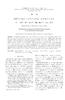
2 地質調査研報 2012 年第 63 巻第 5/6 号 第 1 図関東平野の地質図と各コアの掘削地点. 地質図は杉山ほか (1997) を簡略化.(TZ: 所沢コア,KJ: 川島コア,GD: 行田コア,SB:GS- SB-1,FS: 深作 A-1 コア,WM: 鷲宮コア, KK: 春日部コア,KGH: 越谷東コア ). Fig.1 Geologic map of Kanto Plain and locality of cores, which are examined in this study. Geologic map of Kanto Plain simplified after Sugiyama et al. (1997) (TZ: Tokorozawa, KJ: Kawajima, GD: Gyoda, SB: GS-SB-1, FS: Fukasaku A-1, WM: Washimiya, KK: Kasukabe, KGH: Koshigaya-Higashi). 河性海水準変化によるものであると考えられている ( 例えば, 中澤 中里,2005). このような堆積盆地において, 層序を確立し地下地質構造を明らかにするためには, ボーリング試料の火山灰層序や古地磁気層序を明らかにすることに加え, 挟在する海成層を正確に識別して, 海成層の対比を行うことが重要である. 例えば, 大阪平野では,Ma-1,Ma0,Ma1 から Ma13 と名付けられた海成層の対比が, 堆積盆地の形成史を明らかにする上で重要な役割を果たしている ( 例えば, 市原 ( 編 ),1993, 吉川 三田村,1999). ボーリング試料の海成層の認定には, 堆積相の観察とともに, 産出する様々な化石のデータを合わせた総合的解析を行うことが望ましい ( 例えば, 中澤ほか,2006). このようなボーリング解析には珪藻化石がしばしば利用される. 珪藻はそれぞれの分類群が, 塩分,pH, 水流, 栄養塩濃度等, 特定の環境に対応して生息するため, 水質指標生物として知られている ( 渡辺ほか,2005). さらに, その珪酸質の被殻は化石として堆積物にのこされやすく, 地層が形成された当時の環境を推測するための指標化石として利用されてきた ( 例えば,Stoermer and Smol, 1999, eds.). ボーリング試料に含まれる珪藻化石の有無は, 肉眼観察結果を補い海成 非海成層の識別に利用される. 特に, 貝化石を含まない海成層の識別には有効な手段であることが多い. 関東平野中央部においても, いくつかのボーリングコアにおいて, 海成層が識別されている. 関東平野中央部地質研究会 (1994) は, 掘削深度 600 m の春日部観測井コアと川島観測井コアの海成層を, 貝化石, 有孔虫化石, 珪藻化石の産状, 硫黄分析結果から報告した. 埼玉県 (1996) は掘削長 350 m の深作 A-1 コアにおいて, 深度 m の海生層準を珪藻化石の産出から推定した. 納谷ほか (2009), 山口ほか (2009) では, 埼玉県菖蒲町で掘削された GS-SB-1 コアの海成層を, 海生珪藻化石の産出と層相から認定した. 本報告は, 関東平野中央部の地下地質層序を構築する 上での基礎的情報を提供することを目的として, 関東平野中央部で掘削された 7 本の長尺ボーリングコア ( 掘進長 m) の柱状図を作成し, これらのボーリングコアに挟在する海成層準を, 海生珪藻化石産出層準と, 貝化石産出層準, 層相から詳細に識別した結果を研究資料として報告する. 既に海成層準が報告されていた深作 A-1 コア, 春日部コア, 川島コアについても珪藻化石の再検討を行い, より詳細な海成層の認定を試みた. さらに, それぞれの海成層準に対し系統的番号を設定し, 各コアにおける層群単位の大まかな層序区分を示した. 本報告ではそれぞれの海成層の対比および年代については詳しく議論しないが, 現在同時に進められている火山灰層序, 古地磁気層序, 花粉化石層序, 等を総合した地下標準層序確立のための基準となる資料として活用されることが期待される. 2. 試料の概要 2.1 ボーリングコア本研究で使用したコアは, 埼玉県が設置した地盤沈下観測井のコアである, 春日部コア (KK), 川島コア (KJ), 所沢コア (TZ), 鷲宮コア (WM), 行田コア (GD), 越谷東コア (KGH) と, 同じく埼玉県が実施した活断層調査で掘削された深作 A-1 コア (FS) である ( 第 1 表, 第 1 図 ). コアの柱状図は, 観測井設置および活断層調査の報告書 ( 埼玉県,1979,1981,1983,1985,1986,1991,1996) に基づき作成し, 埼玉県に保管されているコアを改めて観察し部分的に修正した. コアの観察に基づき, 貝化石の産出層準および生痕化石の産出層準を明らかにするとともに, 次に述べる方法で海生珪藻化石産出層準を明らかにし, 海成層の認定を行った. 2.2 プレパラート作成方法と観察方法珪藻殻の観察には, 処理方法の異なる 2 種類のプレパラート ( 手法 A および手法 B) を用いた. それぞれの試 148
3 関東平野中央部で掘削されたボーリングコアの海成層準 ( 納谷ほか ) 第 1 表各コアの名称, 略称, 掘削長, 孔口標高, 緯度経度および掘削年. Table 1. Name, abbreviated name, length, elevation, latitude-longitude and drilled year of examined cores in this study. ボーリング名称 コア略称 掘進長 (m) 孔口標高 (m) 緯度経度 掘削年 出典 1 所沢地盤沈下観測所 所沢 (TZ) N35 47'56.9" E139 28'13.1" 埼玉県 (1979) 2 鷲宮地盤沈下観測所 鷲宮 (WM) N E 埼玉県 (1981) 3 行田地盤沈下観測所 行田 (GD) N36 8'14.7" E139 31'12.0" 1982 埼玉県 (1983) 4 越谷東地盤沈下観測所 越谷東 (KGH) N35 54'8.0" E139 48'55.5" 埼玉県 (1985) 5 川島地盤沈下観測所 川島 (KJ) N E 埼玉県 (1986) 6 春日部地盤沈下観測所 春日部 (KK) N E 埼玉県 (1991) 7 埼玉県活断層調査 A-1 深作 A-1(FS) N E 埼玉県 (1996) 8 菖蒲コア (GS-SB-1) 菖蒲 (SB) N E 山口ほか (2009) 料観察に用いたプレパラート作成方法は付表に示した. 手法 A 乾燥した堆積物数 g を軽く押しつぶし, バイアル瓶に移し, 蒸留水を注ぎ全量 15 cc となる懸濁液を作成する. バイアル瓶をぬるま湯で湯煎しながらよく撹拌する. この懸濁液を適量希釈し, 希釈された懸濁液を 18 x 18 mm のカバーグラス上に 0.5 ml 滴下し,40 に設定したホットプレート上で乾燥させる. 封入材 ( プルーラックス ) でスライドグラスに貼り付けプレパラートとする. 手法 B 乾燥した堆積物を砕き, ごま粒程度の大きさのかけらをピンセットで 22 x 24 mm のカバーグラス上に乗せ, 数滴の蒸留水を加え爪楊枝ですりつぶしながら撹拌し懸濁させる.40 に設定したホットプレート上で乾燥させた後, 光硬化樹脂 ( 古澤地質製 ) でスライドグラスに貼り付けプレパラートとする. 検鏡は, 倍率 600 倍 ( 対物レンズ 60 倍 ) の微分干渉装置付き生物顕微鏡を用いて行った. 少なくとも数測線を走査して観察し, 必要に応じて倍率 400 倍 ( 対物レンズ 40 倍 ) にて全面走査による観察も行った. 淡水生種と汽水生 海生種の産出頻度を, 次の基準に従って区分した. abundant ( 多産 ): ほぼすべての視野に 1 殻以上産出する. common ( 普通 ): すべての視野には産出しないが,1 測線上に数殻以上産出する. rare ( 少産 ):1 測線上あるいは数測線上に 1 殻程度産出する. valve fragment only or very rare ( 破片のみ, もしくは稀産 ): 珪藻殻の殻片しか産出しない, もしくはプレパラート全面に数殻しか産出しない. no diatom valves found ( 無産出 ): 全く珪藻殻が観察されない. 種の詳しい同定のために, 倍率 1,000 倍 ( 油浸対物レンズ 100 倍 ) による観察と, 種によって走査電子顕微鏡による殻の微細構造の観察を行った. 珪藻の同定と生態は Krammer and Lange-Bertalot (1988, 1991),Patric and Reimer (1966, 1975),Hartley (1996),Round et al. (1990),Snoeijis ed. (1993, ed.),snoeijis and Vilbaste (1994, eds.),snoeijis and Potapova (1995, eds.),snoeijis and Kasperovičienė (1996, eds.),snoeijis and Balashova (1998, eds.),vos and De Wolf (1993), 渡辺ほか (2005), Witkowski et al. (2000) 等を参考にした. 2.3 海成層の認定方法本研究では,1) 海生 汽水生珪藻の産出,2) 貝化石の産出,3) 生痕化石 Macaronichnus segregatis の産出 ( 例えば,Seike,2007,2009) のうち, いずれかが認められた層準を海成層と判断した. 海成層の下限と上限は, 原則上記の海成層指標が含まれる層相の境界としたが, 同じユニット内に海成層と淡水成層の境界が認定された場合や, 実際の層相の連続性から柱状図の層相境界をまたぐと判断された場合は, 海成層境界と柱状図の層相境界が一致していない. 認定された海成層準について, 各コアの略称番号 ( 第 1 表 ) とコアの上位から下位に向かって M1 から開始する番号の組み合わせで番号を設定した. 3. 海生 汽水生珪藻産出層準と海成層準の認定検鏡したコアで産出した主な分類群を淡水生及び汽水 海生種の区分とともに第 2 表に示す. それぞれのコアにおける検鏡を行った試料の層準, 淡水生種と汽水 海生種の産出頻度を柱状図と貝化石の産出層準とともに第 2 図 第 8 図に示す. 水野 納谷 (2011) で示されたテフラについては, 試料番号と層準を柱状図に示し, 海成層との層位関係を示した. 第 9 図には, コア全体が概観できる小縮尺の柱状図, 海成層準, 広域テフラ, 既存研究に基づいた古地磁気極性を示し, すでに公表されている菖蒲コア (GS-SB-1: 山口ほか 2009; 納谷ほか,2009) の結果も示した. 検鏡した全試料の深度, プレパラート作成方法, 珪藻化石産出頻度を付表 1 にまとめた. 以下, それぞれのコアにおける珪藻化石産出層準と海成層の認定結果を述べる. 3.1 所沢コア (TZ)( 第 2 図 ) 検鏡は所沢コアの合計 92 試料で行われた. このうち珪藻化石は合計 25 試料で産出した. 無産出および稀産試料は合わせて 67 試料だった. 珪藻化石が産出した
4 地質調査研報 2012 年第 63 巻第 5/6 号 第 2 表関東平野中央部ボーリングコアに産出した主な珪藻化石. Table 2. Common diatom species occurred in drillcores in central Kanto Plain. Marine to brackish species Freshwater species (continued) Actinocyclus normanii f. subsalsa (Juhlin-Dannfelt) Hustedt Achnantethidium spp. Actinoptychus spp. Aulacoseira spp. Campylosira cymbelliformis (A. Schmidt) Grun. ex Van Heurck Cocconeis placentula Ehrenb. Cocconeis scutellum Ehrenberg Cyclotella meneghiniana Kützing Cyclotella baltica (Grunow) Håkansson Cymbella spp. Cyclotella choctawhatcheeana A.K.S.Prasad Decussata spp. Cyclotella cf. stylorum Brightwell Diadesmis confervacea Kützing Cymatosira belgica Grunow in Van Heurck Diadesmis contenta (Grunow ex Van Heurck) D.G. Mann Cymatotheca weissflogii (Grunow) Hendey Encyonema spp. Diploneis spp. Epithemia sp. Fallacia spp. Eunotia spp. Giffenia cocconeiformis (Grunow) Round & Basson Fragilaria spp. Grammatophora sp. Fragilariforma sp. Hyalodiscus sp. Frustulia vulgaris (Thwaites) De Toni Lancineis rectilatus Naya Gomphonema spp. Melosira spp. Hannaea arcus var. hattoriana (F.Meister) Ohtsuka Navicula spp. Hantzschia amphioxys (Ehrenberg) Grunow in Cleve et Grunow Paralia spp. Hippodonta spp. Petroneis marina (Ralfs in Pritchard) D.G.Mann Luticola spp. Plagiogramma staurophorum (Gregory) Heiberg Melosira varians Agardh Pleurosigma sp. Navicula spp. Psamodictyon spp. Neidium spp. Pseudopodosira kosugii Tanimura & Sato Nitzschia spp. Pseudostaurosira spp. Orthoseira roeseana (Rabenhorst) O'Meara Rhizosolenia spp. Pinnularia spp. Rhopalodia acuminata Krammer Placoneis spp. Seminavis strigosa (Hustedt) Danieledis & Economou-Amilli Planothidium spp. Skeletonema costatum (Greville) Cleve Pseudostaurosira spp. Thalassionema nitzschioides (Grunow) Grun. Puncticulata spp. Thalassiosira spp. Reimeria sinuata (Gregory) Kociolek & Stoermer Trachyneis sp. Stauroneis spp. Tryblionella granulata (Grunow) D.G.Mann Staurosira spp. Tryblionella lanceola Grunow ex Cleve Staurosirella spp. Tryblioptychus cocconeiformis (Cleve) Hendey Stephanodiscus spp. Surirella spp. Freshwater species Synedra spp. Achnantethes spp. Synedrella sp. Achnanthes inflata (Kützing) Grunow Tabellaria sp. 試料のうち, 汽水 海生種は 22 試料で産出した. 汽水 海生種が産出した層準と貝化石の産出層準より, 所沢コアには合計 15 層準の海成層が認められた. 海成層の番号と深度は上位より,TZ-M1 ( m),tz-m2 ( m),tz-m3 ( m), TZ-M4 ( m),tz-m5 ( m),tz- M6 ( m),tz-m7 ( m),tz-m8 ( m),tz-m9 ( m),tz-m10 ( m),tz-m11 ( m),tz-m12 ( m),tz-m13 ( m),tz-m14 ( m),tz-m15 ( m) である. 3.2 鷲宮コア (WM)( 第 3 図 ) 検鏡は鷲宮コアの合計 122 試料で行われた. このうち 珪藻化石は合計 38 試料で産出した. 無産出および稀産試料は合わせて 84 試料だった. 珪藻化石が産出した 38 試料のうち, 汽水 海生種は 14 試料で産出した. 汽水 海生種が産出した層準と貝化石の産出層準より, 鷲宮コアには合計 6 層準の海成層が認められた. 海成層の番号と深度は上位より,WM-M1 ( m),wm-m2 ( m),wm-m3 ( m), WM-M4 ( m),wm-m5 ( m), WM-M6 ( m), である. 3.3 行田コア (GD)( 第 4 図 ) 検鏡は行田コアの合計 147 試料で行われた. このうち珪藻化石は合計 75 試料で産出した. 無産出および稀産試料は合わせて 72 試料だった. 珪藻化石が産出した
5 関東平野中央部で掘削されたボーリングコアの海成層準 ( 納谷ほか ) 試料のうち, 汽水 海生種は 11 試料で産出した. 汽水 海生種が産出した層準と貝化石の産出層準より, 行田コアには合計 3 層準の海成層が認められた. 海成層の番号と深度は上位より,GD-M1 ( m),gd-m2 ( m),gd-m3 ( m) である. 3.4 越谷東コア (KGH)( 第 5 図 ) 検鏡は越谷東コアの合計 73 試料で行われた. このうち珪藻化石は合計 34 試料で産出した. 無産出および稀産試料は合わせて 39 試料だった. 珪藻化石が産出した 34 試料のうち, 汽水 海生種は 19 試料で産出した. 汽水 海生種が産出した層準と貝化石の産出層準より, 越谷東コアには合計 12 層準の海成層が認められた. 海成層の番号と深度は上位より,KGH-M1 ( m),kgh-m2 ( m),kgh-m3 ( m),kgh-m4 ( m),kgh-m5 ( m),kgh-m6 ( m),kgh-m7 ( m),kgh-m8 ( m),hgh-m9 ( m),kgh-m10 ( m),kgh-m11 ( m),kgh-m12 ( m), である. 3.5 川島コア (KJ)( 第 6 図 ) 検鏡は川島コアの合計 143 試料で行われた. このうち珪藻化石は合計 71 試料で産出した. 無産出および稀産試料は合わせて 72 試料だった. 珪藻化石が産出した 71 試料のうち, 汽水 海生種は 36 試料で産出した. 汽水 海生種が産出した層準と貝化石の産出層準より, 川島コアには合計 14 層準の海成層が認められた. 海成層の番号と深度は上位より,KJ-M1 ( m),kj-m2 ( m),kj-m3? ( m),kj- M4 ( m),kj-m5 ( m),kj-m6 ( m),kj-m7 ( m),kj-m8 ( m),kj-m9 ( m),kj-m10 ( m), KJ-M11 ( m) KJ-M12 ( m),kj- M13 ( m),kj-m-14 ( m) である. KJ-M1 層準は, 今回珪藻の検鏡をしていないが, 関東平野中央部珪藻グループ (1994) により海生珪藻の産出が報告されているため, 海成層と認定した.KJ-M3? は, 今回の検鏡では淡水生種のみ産出し, 海生および汽水生珪藻の産出が確認できなかったが, 関東平野中央部珪藻グループ (1994) では汽水生珪藻である Diploneis smithii の産出が報告されているため, 暫定的に海成層とした. 関東平野中央部地質研究会 (1994) は, 川島コアで本研究と同じく 14 層準の海成層を識別している. これらの海成層深度は, 本研究の海成層深度とほぼ一致する. 3.6 春日部コア (KK)( 第 7 図 ) 検鏡は春日部コアの合計 164 試料で行われた. 珪藻化 石は合計 72 試料で産出した. 無産出および稀産試料は 合わせて 92 試料だった. 珪藻化石が産出した 72 試料の うち, 汽水 海生種は 45 試料で産出した. 汽水 海生 種が産出した層準と貝化石の産出層準より, 春日部コアには合計 18 層準の海成層が認められた. 海成層の番号と深度は上位より,KK-M1 ( m),kk-m2 ( m),kk-m3 ( m), KK-M4 ( m),kk-m5 ( m),kk- M6 ( m),kk-m7 ( m),kk- M8 ( m),kk-m9 ( m),kk- M10 ( m),kk-m11 ( m),kk- M12 ( m),kk-m13 ( m),kk- M14 ( m),kk-m15 ( m),kk- M16 ( m),kk-m17 ( m),kk-m18 ( m) である. 関東平野中央部地質研究会 (1994) は, 春日部コアで 17 層準の海成層を識別している. 本研究の KK-M10 海成層は関東平野中央部地質研究会 (1994) で識別されていないが, それ以外の海成層の深度はほぼ一致する. なお, 関東平野中央部地質研究会 (1994) は, 貝化石, 有孔虫化石, 海生珪藻化石が共通して産出する海成層に対して,1から12の海成層準分帯を行っている. 本研究の海成層とは,1と KK-M1,2と KK-M3,3と KK-M4, 4と KK-M5,5と KK-M6,6と KK-M7,7と KK-M9, 8と KK-M11,9と KK-M12,10と KK-M13,11と KK- M17,12と KK-M18 がそれぞれ対応する. 3.7 深作 A-1 コア (FS)( 第 8 図 ) 検鏡は深作コアの合計 150 試料で行われた. このうち珪藻化石は合計 61 試料で産出した. 無産出および稀産試料は合わせて 89 試料だった. 珪藻化石が産出した 61 試料のうち, 汽水 海生種は 23 試料で産出した. 汽水 海生種が産出した層準と貝化石の産出層準より, 深作コアには合計 8 層準の海成層が認められた. 海成層の番号と深度は上位より FS-M1 ( m),fs-m2 ( m),fs-m3)( m),fs- M4 ( m),fs-m5 ( m),fs- M6 ( m),fs-m7 ( m),fs-m8 ( m), である. 4. 海成層の層序区分 : 沖積層 下総層群 上総層群 地下地質層序の確立のためには, 海成層準, 火山灰層序, 花粉層序, 古地磁気層序などを総合的に考慮する必要がある. 本稿の主題は海成層準の識別なので, 詳細な層序区分については議論しないが, 現段階で明らかにされている層序指標を用いて, 各コアにおける大局的な層序区分 ( 沖積層 下総層群 上総層群 ) を検討した. 151
6 地質調査研報 2012 年第 63 巻第 5/6 号 第 2 図 A 所沢コア (TZ) の柱状図, 貝化石産出深度, 珪藻化石分析深度, 珪藻化石産出頻度と海成層深度 ( 深度 m). Fig.2A Columnar section, molluscan shell occurrences, diatom samples, diatom valve abundance and marine intervals in Tokorozawa (TZ) core. (0-200 m depth). 152
7 関東平野中央部で掘削されたボーリングコアの海成層準 ( 納谷ほか ) 第 2 図 B 所沢コア (TZ) の柱状図, 貝化石産出深度, 珪藻化石分析深度, 珪藻化石産出頻度と海成層深度 ( 深度 m). Fig.2B Columnar section, molluscan shell occurrences, diatom samples, diatom valve abundance and marine intervals in Tokorozawa (TZ) core. ( m depth). 153
8 地質調査研報 2012 年第 63 巻第 5/6 号 第 2 図 C 所沢コア (TZ) の柱状図, 貝化石産出深度, 珪藻化石分析深度, 珪藻化石産出頻度と海成層深度 ( 深度 m). Fig.2C Columnar section, molluscan shell occurrences, diatom samples, diatom valve abundance and marine intervals in Tokorozawa (TZ) core. ( m depth). 154
9 関東平野中央部で掘削されたボーリングコアの海成層準 ( 納谷ほか ) 第 3 図 A 鷲宮コア (WM) の柱状図, 貝化石産出深度, 珪藻化石分析深度, 珪藻化石産出頻度と海成層深度 ( 深度 m). Fig.3A Columnar section, molluscan shell occurrences, diatom samples, diatom valve abundance and marine intervals in Washimiya (WM) core. (0-200 m depth). 155
10 地質調査研報 2012 年第 63 巻第 5/6 号 第 3 図 B 鷲宮コア (WM) の柱状図, 貝化石産出深度, 珪藻化石分析深度, 珪藻化石産出頻度と海成層深度 ( 深度 m). Fig.3B Columnar section, molluscan shell occurrences, diatom samples, diatom valve abundance and marine intervals in Washimiya (WM) core. ( m depth). 156
11 関東平野中央部で掘削されたボーリングコアの海成層準 ( 納谷ほか ) 第 3 図 C 鷲宮コア (WM) の柱状図, 貝化石産出深度, 珪藻化石分析深度, 珪藻化石産出頻度と海成層深度 ( 深度 m). Fig.3C Columnar section, molluscan shell occurrences, diatom samples, diatom valve abundance and marine intervals in Washimiya (WM) core. ( m depth). 157
12 地質調査研報 2012 年第 63 巻第 5/6 号 第 4 図 A 行田コア (GD) の柱状図, 貝化石産出深度, 珪藻化石分析深度, 珪藻化石産出頻度と海成層深度 ( 深度 m). Fig.4A Columnar section, molluscan shell occurrences, diatom samples, diatom valve abundance and marine intervals in Gyoda (GD) core. (0-200 m depth). 158
13 関東平野中央部で掘削されたボーリングコアの海成層準 ( 納谷ほか ) 第 4 図 B 行田コア (GD) の柱状図, 貝化石産出深度, 珪藻化石分析深度, 珪藻化石産出頻度と海成層深度 ( 深度 m). Fig.4B Columnar section, molluscan shell occurrences, diatom samples, diatom valve abundance and marine intervals in Gyoda (GD) core. ( m depth). 159
14 地質調査研報 2012 年第 63 巻第 5/6 号 第 4 図 C 行田コア (GD) の柱状図, 貝化石産出深度, 珪藻化石分析深度, 珪藻化石産出頻度と海成層深度 ( 深度 m). Fig.4C Columnar section, molluscan shell occurrences, diatom samples, diatom valve abundance and marine intervals in Gyoda (GD) core. ( m depth). 160
15 関東平野中央部で掘削されたボーリングコアの海成層準 ( 納谷ほか ) 第 4 図 D 行田コア (GD) の柱状図, 貝化石産出深度, 珪藻 Fig.4D 化石分析深度, 珪藻化石産出頻度と海成層深度 ( 深度 m). Columnar section, molluscan shell occurrences, diatom samples, diatom valve abundance and marine intervals in Gyoda (GD) core. ( m depth). 161
16 地質調査研報 2012 年第 63 巻第 5/6 号 第 5 図 A 越谷東コア (KGH) の柱状図, 貝化石産出深度, 珪藻化石分析深度, 珪藻化石産出頻度と海成層深度 ( 深度 m). Fig.5A Columnar section, molluscan shell occurrences, diatom samples, diatom valve abundance and marine intervals in Koshigaya- Higashi (KGH) core. (0-200 m depth). 162
17 関東平野中央部で掘削されたボーリングコアの海成層準 ( 納谷ほか ) 第 5 図 B 越谷東コア (KGH) の柱状図, 貝化石産出深度, 珪藻化石分析深度, 珪藻化石産出頻度と海成層深度 ( 深度 m). Fig.5B Columnar section, molluscan shell occurrences, diatom samples, diatom valve abundance and marine intervals in Koshigaya- Higashi (KGH) core. ( m depth). 163
18 地質調査研報 2012 年第 63 巻第 5/6 号 第 6 図 A 川島コア (KJ) の柱状図, 貝化石産出深度, 珪藻化石分析深度, 珪藻化石産出頻度と海成層深度 ( 深度 m). Fig.6A Columnar section, molluscan shell occurrences, diatom samples, diatom valve abundance and marine intervals in Kawajima (KJ) core. (0-200 m depth). 164
19 関東平野中央部で掘削されたボーリングコアの海成層準 ( 納谷ほか ) 第 6 図 B 川島コア (KJ) の柱状図, 貝化石産出深度, 珪藻化石分析深度, 珪藻化石産出頻度と海成層深度 ( 深度 m). Fig.6B Columnar section, molluscan shell occurrences, diatom samples, diatom valve abundance and marine intervals in Kawajima (KJ) core. ( m depth). 165
20 地質調査研報 2012 年第 63 巻第 5/6 号 第 6 図 C 川島コア (KJ) の柱状図, 貝化石産出深度, 珪藻化石分析深度, 珪藻化石産出頻度と海成層深度 ( 深度 m). Fig.6C Columnar section, molluscan shell occurrences, diatom samples, diatom valve abundance and marine intervals in Kawajima (KJ) core. ( m depth). 166
21 関東平野中央部で掘削されたボーリングコアの海成層準 ( 納谷ほか ) 第 7 図 A 春日部コア (KK) の柱状図, 貝化石産出深度, 珪藻化石分析深度, 珪藻化石産出頻度と海成層深度 ( 深度 m). Fig.7A Columnar section, molluscan shell occurrences, diatom samples, diatom valve abundance and marine intervals of Kasukabe (KK) core. (0-200 m depth). 167
22 地質調査研報 2012 年第 63 巻第 5/6 号 第 7 図 B 春日部コア (KK) の柱状図, 貝化石産出深度, 珪藻分析深度, 珪藻殻産出頻度と海成層深度 ( 深度 m). Fig.7B Columnar section, molluscan shell occurrences, diatom samples, diatom valve abundance and marine intervals in Kasukabe (KK) core. ( m depth). 168
23 関東平野中央部で掘削されたボーリングコアの海成層準 ( 納谷ほか ) 第 7 図 C 春日部コア (KK) の柱状図, 貝化石産出深度, 珪藻化石分析深度, 珪藻化石産出頻度と海成層深度 ( 深度 m). Fig.7C Columnar section, molluscan shell occurrences, diatom samples, diatom valve abundance and marine intervals in Kasukabe (KK) core. ( m depth). 169
24 地質調査研報 2012 年第 63 巻第 5/6 号 第 8 図 A 深作コア (FS) の柱状図, 貝化石産出深度, 珪藻化石分析深度, 珪藻化石産出頻度と海成層深度 ( 深度 m). Fig.8A Columnar section, molluscan shell occurrences, diatom samples, diatom valve abundance and marine intervals of Fukasaku A-1 (FS) core. (0-200 m depth). 170
25 関東平野中央部で掘削されたボーリングコアの海成層準 ( 納谷ほか ) 第 8 図 B 深作コア (FS) の柱状図, 貝化石産出深度, 珪藻化石分析深度, 珪藻化石産出頻度と海成層深度 ( 深度 m). Fig.8B Columnar section, molluscan shell occurrences, diatom samples, diatom valve abundance and marine intervals of Fukasaku A-1 (FS) core. (0-200 m depth). 171
26 地質調査研報 2012 年第 63 巻第 5/6 号 第 9 図 A 関東平野中央部のボーリングコアの小縮尺柱状図, 古地磁気極性, テフラ, 海成層準 ( 所沢コア, 川島コア, 深作コア, 菖蒲コア ). Fig.9A Small-scale column, paleo-magnetic polarity, tephra and marine intervals of drilled cores in central Kanto Plain. (TZ, KJ, FS and SB cores). 172
27 関東平野中央部で掘削されたボーリングコアの海成層準 ( 納谷ほか ) KKÊ(Kasukabe)Ê WMÊ(Washimiya) KGHÊ(Koshigaya-Higashi) GDÊ(Gyoda) DepthÊ(m) Polarity 9) Column Marine intervals Tephra Cyclobalanopsis Group KK-M1 KK-M2 KK-M3 KK-M4 KK-M5 Ks18Ê? KK-M6 KK-M7 KK-M8 KK-M9 KK-M10 KK-M11 Joetsu KK-M12 2) A* ShimosaÊG. 2) 2) KazusaÊG DepthÊ(m) Column Marine intervals Tephra Joetsu Group * WM-M1 A WM-M2 WM-M3 WM-M4 WM-M5 WM-M6 ShimosaÊG. KazusaÊG DepthÊ(m) Column Marine intervals Tephra KazusaÊG. ShimosaÊG. Group A* KGH-M1 KGH-M2 KGH-M3 KGH-M4 KGH-M5 KGH-M6 KGH-M7 KGH-M8 KGH-M9 KGH-M10 KGH-M11 KGH-M12 DepthÊ(m) Column Marine intervals Tephra Cyclobalanopsis GD-M1 GD-M2 U8 KazusaÊG. ShimosaÊG. Group A* 10) KK-M KK-M14 Kd12 KK-M KK-M Kd KK-M17 Chigase6? KK-M18 Normal Undefine Reversed Polarity Column Cyclobalanopsis VolcanicÊashÊsoil zones ClayÊand silt marineêintervals Sand Gravel Tephra 550 Azu-Koen1 GD-M )ÊAidaÊandÊGeologicalÊResearchÊGroupÊofÊ ÊÊÊÊtheÊCentralÊKantoÊPlainÊ(1992) 10)ÊSaitamaÊPref.Ê(1983) 600 A*:ÊtheÊlatestÊPleistoceneÊtoÊHoloceneÊincisedÊvalleyÊfills 第 9 図 B 関東平野中央部のボーリングコアの小縮尺柱状図, 古地磁気極性, テフラ, 海成層準 ( 春日部コア, 鷲宮コア, 越谷東コア, 行田コア ). Fig.9B Small-scale column, paleo-magnetic polarity, tephra and marine intervals of drilled cores in central Kanto Plain. (KK, WM, KGH and GD cores). 173
28 地質調査研報 2012 年第 63 巻第 5/6 号 荒川低地および中川低地の地下には, 最終氷期の下刻谷が完新世に埋積され形成された沖積層が分布している. 今回解析したコアのうち, 沖積低地上から掘削された鷲宮, 越谷東, 川島, 春日部コアの最上部の各海成層 (WM-M1,KGH-M1,KJ-M1,KK-M1) は沖積層の海成層に相当する ( 第 9 図 ). 関東平野中央部において, 沖積層の下位に分布する更新統は, 便宜的に下位の上総層群と上位の下総層群に区分されてきた. 中澤ほか (2009) は, 埼玉県越谷市で掘削された GS-KS-1 コアの解析結果から, 上総層群と下総層群の境界に相当する地蔵堂層の基底面 ( 徳橋 遠藤, 1984), すなわち海洋酸素同位体ステージ (MIS) 12 に形成された侵食面 ( 例えば, 中里 佐藤,2001) の特定を行った. その結果, 関東平野中央部においては, 房総半島において認められる上総層群と下総層群の層相の違いは認められず, 上総層群相当層においても, 下総層群同様に陸成層と浅海成層の互層からなることが指摘された. 今回分析したコアの層相は, コア全体を通して海成層と陸成層の互層からなり, 層相のみから両層群を区別するのは困難である. 下総層群地蔵堂層に相当する MIS11 層準は, 日本の様々な地域において温暖帯常緑広葉樹のアカガシ亜属 (Cyclobalanopsis) 花粉及び大型遺体が多産するという特徴が知られている ( 杉山,1991;Furutani, 1989;Okuda et al. 2006; 本郷,2009, など ). 関東平野中央部においても, 深作 A-1 コアにおいて Cyclobalanopsis の多産層準の層序学的位置が検討され, 本花粉化石の MIS11 層準の指標としての有用性が示された ( 本郷 水野,2009). そこで, 既に報告されている Cyclobalanopsis 多産層準を指標として, 各コアにおける下総層群最下部層である地蔵堂層に相当する MIS11 層準を検討し, 上総層群と下総層群の境界層準の推定を試みた. 本郷 水野 (2009) 及び本郷ほか (2011) は, 深作 A-1 コアと菖蒲コアにおける Cyclobalanopsis 多産層準と MIS11 層準の層序関係を検討した. これらに基づけば, 深作 A-1 コアでは Fs-Pol-12 帯が, 菖蒲コアでは SB-Pol-14 帯および SB-Pol-15 帯が Cyclobalanopsis 多産層準, すなわち MIS11 層準に相当し, それらは FS-M4 及び SB-M4 海成層準にそれぞれ含まれる ( 第 9 図 B). 春日部コアにおいては, 沖積層を除くと 2 層準で Cyclobalanopsis の多産が認められる (Fagus-Cyclobalanopsis 亜帯,Fagus- Haploxylon-Cyclobalanopsis 亜帯 : 関東平野中央部花粉グループ,1994). このうち, 上総層群笠森層の Ks18 テフラに対比される KKT テフラ ( 水野 納谷,2011) より上位にあるのは,Fagus-Cyclobalanopsis 亜帯のみであり, この層準は KK-M5 海成層に含まれる ( 第 9 図 B). 川島コアでは, 沖積層以外で Cyclobalanopsis が多産する層準が 1 層準認められ (Fagus-Cyclobalanopsis 亜帯 : 関東平野中央部花粉グループ,1994), この層準は KJ-M4 海成層に相当する ( 第 9 図 A). 行田コアでは, 水野ほか (2004), 松島ほか (2009) で検討されたように, 深度 m 付近に Cyclobalanopsis 多産層準があり ( 埼玉県, 1983), この層準は GD-M2 に含まれる ( 第 9 図 B). 鷲宮 越谷東両コアでは, 花粉化石群集の資料がないため周辺のコアの層準から推測せざるを得ない. 鷲宮コアは菖蒲コア 行田コアの MIS11 層準 (SB-M4 GD- M2) とほぼ同深度に位置する WM-M5 を MIS11 層準と推定した ( 第 9 図 B). 越谷東コアでは, 本コアと近接した地点で掘削された中澤ほか (2009) の GS-KS-1 コアの地蔵堂層相当層深度 ( およそ m) とほぼ同深度に分布する KGH-M4 を MIS11 層準と推定した ( 第 9 図 B). MIS11 層準に相当する海成層の基底部を上総層群と下総層群の境界層準と考えると, 鷲宮, 行田, 越谷東, 川島, 春日部, 深作 A-1, 菖蒲, 各コアにおける上総層群と下総層群境界層準は, それぞれ WM-M5,GD- M2,KGH-M4,KK-M5,FS-M4,SB-M4 の基底部付近と推定される ( 第 9 図 ). この推定は, 中澤ほか (2009) が GS-KS-1 コアで示したように, 海成層の基底部が砂礫層を伴わない侵食面であるという判断に基づく. なお, MIS11 海成層の下位に MIS12 の低海水準期に形成された谷を開折した河川堆積物もしくは扇状地堆積物が部分的に分布し, これら砂礫層が地蔵堂層相当層基底となる可能性 ( 平社,2008a,b, 松島ほか,2009) は残されているが, 現段階ではテフラ層序や花粉層序の裏付けが十分に得られていないため詳細に検討していない. 謝辞 : 本研究を進めるにあたり, 産業技術総合研究所の本郷美佐緒氏 ( 当時 ) と山口正秋氏 ( 当時 ) には試料採取に, 産業技術総合研究所の國本節子氏, 茨城大学理学部の石川友美氏 ( 当時 ), 図子田香織氏 ( 当時 ), 日本大学文理学部の西内李佳氏 ( 当時 ) と齊藤貴之氏 ( 当時 ) には珪藻プレパラートの作成に協力していただいた. ここに記してお礼申し上げます. 本研究には, 文部科学省科学技術振興調整費 統合化地下構造データベースの構築 ( 平成 年度 ), 産業技術総合研究所の運営交付金 関東平野の地震動特性と広域地下水流動系の解明に関する地質学的総合研究 ( 平成 年度 ) 並びに 沿岸海域の地質 活断層調査 ( 平成 年度 ) を使用した. 文献会田信行 関東平野中央部地質研究会 (1992) 春日部地盤沈下観測井の古地磁気層序. 地球科学,46, 会田信行 野村哲 北爪智啓 (1994) 関東平野中央部ボーリングコアの古地磁気層序. 地団研専報,no.42,
29 関東平野中央部で掘削されたボーリングコアの海成層準 ( 納谷ほか ) Furutani, M. (1989) Stratigraphical subdivision and pollen zonation of the Middle and Upper Pleistocene in the coastal Area of Osaka Bay, Japan. Journal of Geosciences, Osaka City University, 32, Hartley, B. (1996) An Atlas of British Diatoms. Biopress Limited, Bristol, UK, 601 p. 市原実 (1993 編 ) 大阪層群. 創元社, 大阪,340p. 平社定夫 (2008a) 関東平野中央部における中 上部更新統の堆積相および堆積シーケンス. 地球科学,62, 平社定夫 (2008b) 関東平野における中 上部更新統の層序および構造運動. 地球科学,62, 本郷美佐緒 (2009) 大阪堆積盆地における中部更新統の花粉生層序と古環境変遷. 地質雑,115, 本郷美佐緒 水野清秀 (2009) 埼玉県さいたま市で掘削された深作 A-1 ボーリングコアの花粉化石群集. 地調研報,60, 本郷美佐緒 納谷友規 山口正秋 水野清秀 (2011) 関東平野中央部埼玉県菖蒲町で掘削された 350 m ボーリングコア (GS-SB-1) から産出した花粉化石群集. 地調研報,62, 関東平野中央部地質研究会 (1994) 関東平野中央部地下地質の編年と対比. 地団研専報,no.42, 関東平野中央部花粉グループ (1994) 関東平野中央部ボーリングコアの花粉層序 春日部 (60KK) および川島 (84KJ) ボーリングコアの花粉分析. 地団研専報,no.42, 関東平野中央部珪藻グループ (1994) 関東平野中央部ボーリングコアの珪藻遺骸群集. 地団研専報,no.42, Krammer, K. and Lange-Bertalot, H. (1988) Bacillariophyceae. 2. Teil: Bacillariaceae, Epithemiaceae, Surirellaceae. In Ettl, H., Gerloff, J., Heynig, H. and Mollenhauer, D., eds., Süsswasserflora von Mitteleuropa, Band 2/2. VEB Gustav Fischer Verlag, Jena. 596 p. Krammer, K. and Lange-Bertalot, H. (1991) Bacillariophyceae. 3. Teil: Centrales, Fragilariaceae, Eunotiaceae. In Ettl, H., Gerloff, J., Heynig, H. and Mollenhauer, D., eds., Süsswasserflora von Mitteleuropa, Band 2/ pp. Gustav Fischer Verlag, Stuttgart, Jena. 松島紘子 須貝俊彦 水野清秀 八戸昭一 (2009) 関東平野内陸部, 吹上 行田地域における中 上部更新統の地下層序と堆積環境変化. 第四紀研究,48, 水野清秀 納谷友規 (2011) 広域テフラと海成層層準の認定に基づく関東平野中央部のボーリングコアの対比. 地質調査総合センター速報,56, 水野清秀 須貝俊彦 八戸昭一 中里裕臣 杉山雄一 石山達也 中澤努 松島紘子 細矢卓志 (2004) ボー リング調査から推定される深谷断層南東部の地質構造と活動性. 活断層 古地震研究報告,4, 中里裕臣 佐藤弘幸 (2001) 下総層群の年代と 鹿島 隆起帯の運動. 第四紀研究,40, 中澤努 中里裕臣 (2005) 関東平野中央部に分布する更新統下総層群の堆積サイクルとテフロクロノロジー. 地質雑,111, 中澤努 中島礼 植木岳雪 田辺晋 大嶋秀明 堀内誠示 (2006) 大宮台地の地下に分布する更新統下総層群木下層のシーケンス層序学的研究. 地質雑,112, 中澤努 中里裕臣 大嶋秀明 堀内誠示 (2009) 関東平野中央部における上総 下総層群境界 : 越谷 GS-KS-1 コアでの MIS12 層準の特定. 地質雑,115, 納谷友規 山口正秋 水野清秀 (2009) 関東平野中央部埼玉県菖蒲町で掘削された 350 m ボーリングコア (GS-SB-1) の珪藻化石産出層準と淡水成層準及び海成層準の識別. 地調研報,60, Okuda, M., Nakazato, H., Miyoshi, N., Nakagawa, T., Okazaki, H., Saito, S. and Taira, A. (2006) MIS11-19 pollen stratigraphy from the 250-m Choshi core, northeast Boso Peninsula, central Japan: Implications for the early/mid-brunhes ( ka) climate signals. Island Arc, 15, Patrick, R. and Reimer, C.W. (1966) The diatoms of the United States, exclusive of Alaska and Hawaii, Volume 1-Fragilariaceae, Eunotiaceae, Achnanthaceae, Naviculaceae. Academy of Natural Sciences of Philadelphia Monograph, 13, Sutter House, Lititz, 688 p. Patrick, R. and Reimer, C.W. (1975) The diatoms of the United States, exclusive of Alaska and Hawaii, Volume 2, Part 1-Entomoneidaceae, Cymbellaceae, Gomphonemaceae, Epithemaceae. Academy of Natural Sciences of Philadelphia Monograph, 13, Sutter House, Lititz, 213 p. Round, F. E., Crawford, R.M. and Mann, D.G. (1990) The Diatoms. Biology & Morphology of the genera. Cambridge University Press, London, 747 p.0 埼玉県 (1979) 所沢地盤沈下観測所地質調査委託業務報告書昭和 54 年. 埼玉県環境部水質保全課,157p. 埼玉県 (1981) 鷲宮地盤沈下観測所地質調査報告書昭和 56 年. 埼玉県環境部水質保全課,174p. 埼玉県 (1983) 行田地盤沈下観測所地質調査報告書昭和 58 年. 埼玉県環境部水質保全課,138p. 埼玉県 (1985) 越谷東地盤沈下観測所地質調査報告書昭和 60 年. 埼玉県環境部水質保全課,166p. 埼玉県 (1986) 川島地盤沈下観測所地質調査報告書昭和 60 年. 埼玉県環境部水質保全課,141p. 埼玉県 (1991) 春日部地盤沈下観測所地質調査報告書平 175
30 地質調査研報 2012 年第 63 巻第 5/6 号 成 3 年. 埼玉県環境部水質保全課,210p. 埼玉県 (1996) 埼玉県活断層調査報告書. 埼玉県環境部防災局地震対策課,200p. Seike, K. (2007) Palaeoenvironmental and palaeogeographical implications of modern Macaronichnus segregatis-like traces in foreshore sediments on the Pacific coast of central Japan. Palaeogeography, Palaeoclimatology, Palaeoecology, 252, Seike, K. (2009) Influence of beach morphodynamics on the distributions of the opheliid polychaete Euzonus sp. and its feeding burrows on a sandy beach: paleoecological and paleoenvironmental implications for the trace fossil Macaronichnus segregatis. Palaios, 24, Snoeijs, P. (1993, ed.) Intercalibration and distribution of diatom species in the Baltic Sea. Vol. 1. OPULUS, Uppsala, 130p. Snoeijs, P. and Vibaste, S. (1994, eds.) Intercalibration and distribution of diatom species in the Baltic Sea. Vol. 2. OPULUS, Uppsala, 125p. Snoeijs, P. and Potapova, M. (1995, eds.) Intercalibration and distribution of diatom species in the Baltic Sea. Vol. 3. OPULUS, Uppsala, 125p. Snoeijs, P. and Kasperovičienė, J. (1996, eds.) Intercalibration and distribution of diatom species in the Baltic Sea. Vol. 4. OPULUS, Uppsala, 125p. Snoeijs, P. and Balashova, N. (1998, eds.) Intercalibration and distribution of diatom species in the Baltic Sea. Vol. 5. OPULUS, Uppsala, 144p. Stoermer, E.F. and Smol, J.P. (1999, eds.) The Diatms: Applications for the Environmental and Earth Sciences. Cambridge, London, 469p. 杉山雄一 (1991) 渥美半島 浜名湖東岸地域の中部更新 統 海進 海退サイクルとその広域対比. 地調月報,42, 杉山雄一 須貝俊彦 井村隆介 水野清秀 遠藤秀典 下川浩一 山崎晴雄 (1997) 50 万分の 1 活構造図 8 東京 ( 第 2 版 ), 地質調査所. 鈴木宏芳 (2002) 関東平野の地下地質構造. 防災科学技術研究所研究報告,63,1 19. 徳橋秀一 遠藤秀典 (1984) 姉崎地域の地質. 地域地質研究報告 (5 万分の 1 地質図幅 ), 地質調査所,136p. 植木岳雪 山口正秋 本郷美佐緒 納谷友規 水野清秀 (2009) 関東平野中央部, 埼玉県菖蒲町で掘削された GS-SB-1 コアの古地磁気 岩石磁気測定. 地調研報, 60, Vos, P.C. and De Wolf, H. (1993) Diatoms as a tool for reconstructing sedimentary environments in coastal wetlands; methodological aspects. Hydrobiologia, 269/270, 渡辺仁治 浅井一視 大塚泰介 辻彰洋 伯耆晶子 (2005) 淡水珪藻生態図鑑. 内田老鶴圃, 東京,784p. Witkowski, A., Lange-Bertalot, H. & Metzeltin, D. (2000) Diatom flora of marine coasts I. In Lange-Bertalot, H. ed. Iconographia Diatomologica, Annotated Diatom Micrographs 7. A.R.G. Gantner Verlag K.G., Ruggell, 925 pp. 山口正秋 水野清秀 納谷友規 本郷美佐緒 中里裕臣 中澤努 (2009) 関東平野中央部, 埼玉県菖蒲町で掘削された 350 m ボーリングコア (GS-SB-1) の層相と堆積物物性. 地調研報,60, 吉川周作 三田村宗樹 (1999) 大阪平野第四系層序と深海底の酸素同位体比層序との対比. 地質雑,105, ( 受付 :2012 年 2 月 21 日 ; 受理 :2012 年 7 月 26 日 ) 176
31 関東平野中央部で掘削されたボーリングコアの海成層準 ( 納谷ほか ) 付表 1 Appendix 1. 各コアの珪藻化石を検鏡した試料の深度, プレパラート作成方法, 珪藻化石産出頻度 (slide: スライド作成方法,F: 淡水生種,M-B: 汽水 海生種,a: 多産,c: 普通,r: 少産,fr.: 破片のみ, もしくは稀産,nd: 無産出 ). Depth, procedure for preparation and diatom valve abundance of investigated materials in each core (slide: procedure for slide preparation, F: freshwater species, M-B: Marine and Brackish species, a: abundant, c: common, r: rare, fr.: valve fragment only or very rare, nd: no diatom valves found). Tokorozawa (TZ) Tokorozawa (TZ) Washimiya (WM) depth (m) slide F M-B fr, nd depth (m) slide F M-B fr, nd depth (m) slide F M-B fr, nd B - - nd B - - nd B - - nd B - - nd B - - nd B c B - - nd B - - nd B - - nd B - - nd B - - nd B - - fr B - - nd B - - nd B c B - - nd B - - nd B - - fr B - - nd B - - nd B - - fr B - - nd B - - nd B - - fr B - - nd B - - nd B r B - - nd B - - nd B r B - c B - - nd B c B - c B - - nd B - - fr B - a B - - fr B - - nd Washimiya (WM) B - - nd B - - fr. depth (m) slide F M-B fr, nd B - - nd B - a B c B c B c a B a B - - fr B - c B a B - - fr B - r B c B - - fr B - c B a B - - fr B c a B r a B r B - r B - r B c B - r B - - nd B r B r a B - - fr B - - fr B - a B a B - c B - r B - - fr B - - nd B a B c c B - - nd B a B r c B c r B r B - - fr B - a B a c B c r B - a B c a B - - fr B - a B - - fr B - - fr B - - nd B - - nd B r B - a B - c B - - fr B - - nd B c c B - - fr B - - fr B c a B c B - - fr B - - fr B - - fr B - - fr B - c B r B c B - - nd B - c B - - fr B - c B - - nd B - - nd B - - nd B - - fr B - - nd B - - nd B c B c B - - nd B - - nd B c B - - nd B - - nd B - - nd B - - nd B - - nd B - - nd B - - nd B - - nd B - - fr B - - nd B - - nd B - - fr B r c B - - nd B - - nd B - - nd B - - nd B - - nd B - - nd B - - nd B - - fr B - - nd B - - nd B - - nd B - - fr B - - nd B - - nd B - - nd B - - nd B - - nd B - - nd B - - nd B - - nd B - - nd B - - nd B - - nd B - - nd B - - fr B - - nd B - - nd B - - nd B - - nd B - - nd B - - nd B - - nd B - - nd Gyoda (GD) B - - nd B r a - depth (m) slide F M-B fr, nd B - - nd B - - nd B c B - - nd B - r B r B - - nd B - - fr B c B - - nd B - - fr B r B - - nd B - - fr B a B - - nd B a B c B - - nd B - - fr B - - fr B - - nd B - - nd B a B - - nd B a B c B - - nd B r B - - fr B - - nd B - - nd B a B - - nd B a B r B - - nd B - - nd B c B - - nd B - - nd B - - fr B - - nd B - - nd B c B - - nd B - - nd B a B - - nd B - - nd B a B - - nd B r B c B - - nd B - - fr B a B - - nd B r B a
32 地質調査研報 2012 年第 63 巻第 5/6 号 付表 1 続き. Appendix 1. Continue. Gyoda (GD) Gyoda (GD) Koshigaya-Higashi (KGH) depth (m) slide F M-B fr, nd depth (m) slide F M-B fr, nd depth (m) slide F M-B fr, nd B r B - - nd B c B c B - - nd B - r B c B - - nd B - - fr B a B - - nd B r r B a B - - nd B - - nd B a B - - nd B - - fr B c B - - nd B - - fr B r B - - nd B - - fr B c B - - nd B - - nd B r B - - nd B - - nd B c B a B - - nd B a B c B - - nd B a B - - fr B - - nd B c B c B - - nd B c B a B - - nd B a B r B - - nd B c B r B - - nd B c B r B - - fr B - - nd B r B - r B - - nd B r B - - nd B - - fr B - - nd B - - nd B - - fr B - - nd B - - nd B r r B - - fr B c B - - nd B - - nd B - - nd B - - fr B - r B - - nd B - c B - - fr B - - nd B c r B - r B - - nd B - - nd B r B - - nd B - - nd B - - fr B - - fr B r B - - fr B - - nd B - - nd B r B r c B - - nd B r B a B - - nd B r B c B - - nd B - - fr B r B - - nd B - - fr B - c B r c B - - nd B - - nd B r r B - - nd B - c B c a B - - nd B - c B - a B - - nd B - c B - - nd B - - nd B - r B r a B r B - - nd B c a B - - nd B - - nd B - - nd B - - fr B - r B r B - - nd B - - nd B r B r B c B c B c - - Koshigaya-Higashi (KGH) Kawajima (KJ) B a - - depth (m) slide F M-B fr, nd depth (m) slide F M-B fr, nd B c B - - fr A a B a B - - fr A - c B - - fr B - r A r r B - - nd B - - nd A a B - - fr B - - fr A r B a B - - nd A r B - - nd B - - nd A c B - - nd B - - nd A c B - - nd B - - nd B c B - - nd B - - nd B c B a B - - fr B - - fr B - - nd B r r A - - nd B r B - c A c B - - nd B - r A c B - - nd B r A - - nd B - - nd B a A c B - - nd B r A c B - - fr B c A r B - - fr B a B c B - - nd B a A r c B - - nd B - r A - r B - - nd B - c A - - nd B - - nd B r a A - - nd B - - nd B - c A - - nd B - - nd B c B - - nd B - - nd B c B - - nd B - - nd B - - fr A r c B - - nd B c A r c B - - nd B a A - r B - - nd B r r A - c - 178
33 関東平野中央部で掘削されたボーリングコアの海成層準 ( 納谷ほか ) 付表 1 続き. Appendix 1. Continue. Kawajima (KJ) Kawajima (KJ) Kasukabe (KK) depth (m) slide F M-B fr, nd depth (m) slide F M-B fr, nd depth (m) slide F M-B fr, nd B - r A - - fr A - - nd A - r A - - fr A - - nd A - - nd A - - nd A r r A - - nd A - - nd A - - nd A - c A - - nd B - - nd A - - nd A - - nd A - - nd B - r A - - nd B - - nd A - r A - - nd A - r A - - fr A - - nd B - - fr B - - nd A - - nd A - c A - r A - - nd B - c A c c B - - nd A - r B - - fr B - - nd A - - nd A - - fr B - - nd B a A - - nd B - - nd B - - nd B - r B - - nd B - - nd B - r B - - nd B - - nd A - c B - - nd B - - nd A r B - - nd B - - nd A - r B - - nd B - - nd A - r B - - nd A - - nd A - r B - - nd B - - nd B - - fr B - - nd A - - nd A - - nd B - - nd B - - nd A - - nd B - - nd B r r B - - nd B - - nd B r r B - - nd B - - nd A r A - - fr B - - nd B r A r B - - nd A r r A a r B - - nd A a B r a B - - fr B - - nd B r a B - - fr A - - nd B - - nd B - - nd B - - nd B c B - - nd B c A - - fr B c A - - nd B a A - - nd B c B r r B a - - Kasukabe (KK) A - - fr B c - - depth (m) slide F M-B fr, nd B r r A - - nd A c A - - nd B c A - a B r c A a A - a A - - nd B c A - c A - - nd A - - fr A r c A r B - - nd A a A r B c A c a A a A c A r r A c A - r A - - nd B - - fr A - r A - - nd B r A - c A - - nd B - - nd A r a A - - nd A - - nd A - - nd A - - nd B - - nd A c A - - nd A r c A - - nd A - r B - - fr A - - nd A c a A r A r A a a B - - nd A r c A c A - - nd A c a A r B - - nd A c A c A - - fr A c A - r A - - nd B - r A - - nd B - - nd A r A - r A - - nd A - - nd A - - nd A - - nd A - c B - - nd B - - nd A a A a B - r A r A a r B - a A - c A c B r A - r A c A c A - c A c A - - nd A - - nd A a A - - nd A - - nd A a A c A - - nd A c B r c A r a A c A - - fr A - - fr A - - fr B - - fr A - - nd B - - fr A - - nd A - - nd A - - nd A - - nd A - - nd A - - nd A - - nd A - - nd B - - nd B - - nd A - - nd A - - nd A - - nd 179
34 地質調査研報 2012 年第 63 巻第 5/6 号 付表 1 続き. Appendix 1. Continue. Kasukabe (KK) Fukasaku A-1 (FS) Fukasaku A-1 (FS) depth (m) slide F M-B fr, nd depth (m) slide F M-B fr, nd depth (m) slide F M-B fr, nd A - - nd A - r A - - nd B - - nd A - - nd A - - nd A - - nd A - - nd A - - nd A - - nd A - - nd A - - nd A - - fr A - - fr A - - nd A - - nd A - - fr A - - nd B - - fr A - - nd A - - nd A r r A - - nd A - - nd B - - fr A - - nd A - - nd A - - nd A - - nd A - - nd B - - fr A - - nd A - - nd A r r A - c A - - nd B - c A - - nd A - - fr A r c A - - nd A - - nd A c c A - - fr A - - nd A - - nd A - - fr A - - nd A - r A r A - - nd B - r A - - fr A - - nd A - - nd A - - fr A - - nd A - r A - - nd A - - nd A - c A - - fr A - - nd A - c A - - nd A - - nd B - a A - - nd A - - nd A - c A - - nd A - - nd A - a A - - nd A - - nd A a c A - - nd A - - nd A r a A - - fr A - - nd A - a A - - nd A - - nd A r r A - - nd A - - nd A r c A - - nd A - c A c A - c A - a A - - nd A - a A - c A - - nd A - a A c c B - - nd A - c A - c B - - nd A - c A c B - - nd A - c A c B - - nd A - c A c B - - nd A c c A c B - - nd A - a A c B - - nd A c A - - fr B - - nd A a B - - nd A a B - - nd A - - fr B - - nd A a A r A - - fr A r A c - - Fukasaku A-1 (FS) A - - nd depth (m) slide F M-B fr, nd A - - nd A - - nd A - - fr A - - nd A a A - - fr A a A c A a A a A a A r A a A a r A a A c c A - - nd A r A - - nd A a A A - - nd A - r A r A r r A a A - - fr A a A - - fr A r A - - fr A a A - - nd A a A - - nd A a A - - nd A a A - - nd A a A - - nd A - - nd A - - nd A - - nd A - - nd A - - nd A - - nd A a A - - fr A a A - - fr A r A - a A - - fr A - c A c A - - nd A - - fr A - - nd A c a A - - nd 180
‡P†|ŠéŒØ.ec4
 号 年 月 防災科学技術研究所研究報告 第 孔井一覧 孔井番号は の番号と対応する 4 号 年 月 防災科学技術研究所研究報告 第 反射断面と地質構造との関連を求めることにより 反射 断面から正確な地質構造を得ることが可能になる は下総観測井で行った 探査結果と 観測井近傍での 図 反射断面を合成したものである 山水ほか からわかるように 基盤層や地質境界の反射面が特定で きるため 地質構造との対比が可能となり
地質調査研究報告/Bulletin of the Geological Survey of Japan
 Hideaki Nagamori, Hiroaki Yoshikawa, Koji Hatakeyama, Masumi Terao and Tomotaka Tanabe (2005) Proboscidean footprint fossils from the Lower Pleistocene Okui Formation on the river bed of Chikuma River,
Fig.. Geological map of the central Kanto Plain (after Sugiyama et al., 1997) and the location of the Otone well and other borehole sites r
 and the location of the Otone well and other borehole sites r") 119 5 375 395 2013 5 Jour. Geol. Soc. Japan, Vol. 119, No. 5, p. 375 395, May 2013 JOI: DN/JST.JSTAGE/geosoc/2013.0006 doi: 10.5575/geosoc.2013.0006 1505 m Chronostratigraphy of 1505 m long hot spring
119 5 375 395 2013 5 Jour. Geol. Soc. Japan, Vol. 119, No. 5, p. 375 395, May 2013 JOI: DN/JST.JSTAGE/geosoc/2013.0006 doi: 10.5575/geosoc.2013.0006 1505 m Chronostratigraphy of 1505 m long hot spring
地質調査研究報告/Bulletin of the Geological Survey of Japan
 Takayuki Uchino and Makoto Kawamura (2010) Glaucophane found from meta-basalt in the Nedamo Terrane, Northeast Japan, and its geologic significance. Bull. Geol. Surv. Japan, vol. 61 (11/12), p. 445-452,
白亜紀資料館報19号-済.indd
 19 7 15 1 10 2018 3 Bull. Goshoura Cret. Mus., No.19, 7 15, pls.1 10, March, 2018. 1 464-8601 E430 2 866-0313 4310-5 Paleoenvironmental reconstruction by fossil diatom assemblages from the Yushima Formation
珪藻学会誌2009/ 廣瀬
 Diatom 25 :21 36. December 2009 1 2 1 558-8585 3-3-138 2 589-8511 377-2 Horizontal distribution of diatom remains in the northeastern part of Osaka Bay Kotaro Hirose 1 and Toshikazu Gotoh 2 1 Department
Tsunam is sand layers w ithin peatatthe historic place ofk okutaijitem ple around A kkeshitow n,eastern H okkaido,japan YujiSoeda 1,FutoshiNanayama 2,
 Tsunam is sand layers w ithin peatatthe historic place ofk okutaijitem ple around A kkeshitow n,eastern H okkaido,japan YujiSoeda 1,FutoshiNanayama 2,Nobuhiro Kumasaki 3,Yasuo Tsutsum i 3,HiroshiKurum
地域地質研究報告
 地域地質研究報告 5 万分の 1 地質図幅東京 (8) 第 41 号 NI-54-25-1 野田地域の地質 中澤努 田辺晋 平成 23 年 産業技術総合研究所地質調査総合センター 独立行政法人 野田地域の地質 中澤努 * * 田辺晋 独立行政法人産業技術総合研究所 ( 以下, 産総研 ) 地質調査総合センターは, その前身である地質調査所の 1882 年の創設以来, 国土の地球科学的実態を解明するための調査
69-83水野深谷印刷原稿.indd
 活断層 古地震研究報告,No. 4, p. 69-83, 2004 ボーリング調査から推定される深谷断層南東部の地質構造と活動性 Geologic structure and fault activity in the southeastern part of the Fukaya fault, central Japan inferred from drilling surveys and core
神奈川県西部山北南高感度地震観測井の掘削および孔内検層,Borehole Drilling and Physical Properties of the Yamakita-minami Seismic Observatory in Western Ka
 *1 *2 *3 *4 *5 *5 *6 *6 *2 *7 *5 *4 *5 *5 *6 *6 Borehole Drilling and Physical Properties of the Yamakita-minami Seismic Observatory in Western Kanagawa Prefecture, Central Honshu, Japan Hiroki HAYASHI
*...X Z-.....F.{..
 No. 35 (2000) pp.115-124 The Late Quaternary stratigraphy in the western margin of Yodobashi- dai, northern part of Setagaya-ku, Tokyo Jiro KOMORI, Kunihiko ENDO, Fumihiko HASEGAWA, and Sei TAMURA (Received
《公表資料》柏崎平野周辺の地層の年代について
 柏崎平野周辺の地層の年代について 平成 29 年 4 月 27 日東京電力ホールディングス株式会社 1. 地層の年代評価に関する考え方 2 2. 刈羽テフラに関する東京電力の見解 13 3. 刈羽テフラと藤橋 40の比較 16 4. 地層の年代に関する東京電力の評価の概要 19 5. 藤橋 40の年代に関する考察 29 6. 参考資料 32 7. データ集 38 1 1. 地層の年代評価に関する考え方
Diatom 27: (2011)
") 58 Diatom 27: 58 64. December 2011 Tamie Suzawa et al. Cymbella janischii A.W.F.Schmidt De Toni Gomphoneis minuta Stone Kociolek & Stoermer 1 2 3 1 811-3425 9-17-14 2 819-0395 744 3 184-8501 4-1-1 Blooms
58 Diatom 27: 58 64. December 2011 Tamie Suzawa et al. Cymbella janischii A.W.F.Schmidt De Toni Gomphoneis minuta Stone Kociolek & Stoermer 1 2 3 1 811-3425 9-17-14 2 819-0395 744 3 184-8501 4-1-1 Blooms
 No.50 2015 pp.137 147 Education Note: Stratigraphic Survey Practice in and around Genji-yama Park in the City of Kamakura, in the Northern Part of Miura Peninsula, Central Japan: A guide for Observing
<31305F8E9197BF2D332D F8CCB90EC82CC919497DE92B28DB88C8B89CA81698A A2E786477>
 資料 -3-3 平成 24 年 11 月 7 日 神戸川の藻類調査結果 ( 概要 ) 広島生物環境研究所 中野武登 島根県の一級河川 神戸川 における藻類調査結果を以下に示す 神戸川の志津見ダム下流の 2 地点において 流下藻類と付着藻類に関して調査を実施した 2 地点における水質を評価したが この評価はあくまで付着藻類の観点からの水質評価であることに注意されたい また 2 地点のみの調査 水質評価であり
untitled
 * Coseismic and postseismic coastal environment changes caused by the 1703 Genroku Kanto Earthquake in the southern part of Boso Peninsula, central Japan Jun Muragishi Graduate School of Urban Environmental
Microsoft Word - H Houkoku.doc
 3.3.3. 沿岸の地質調査に基づく地震 津波発生履歴に関する研究 (1) 業務の内容 (a) 業務題目 (b) 担当者 (c) 業務の目的 (d) 1ヵ年の年次実施業務の要約 1) 平成 24 年度 (2) 平成 24 年度の成果 (a) 業務の要約 (b) 業務の成果 1) 下北半島 2) 房総半島 (c) 結論ならびに今後の課題 (d) 引用文献 140 3.3 海底堆積物調査等 3.3.3.
Diatom27_17-32.pdf
 Diatom 27: 17 32. December 2011 Diatoms from the Oidawara Fm. 17 1 2 3 1 515-2692 2739 2 464-8601 3 305-8567 1-1-1 7 Diatom biostratigraphy of the middle Miocene Oidawara Formation in the Mizunami area,
泊発電所 地盤(敷地の地質・地質構造)に関するコメント回答方針
に関するコメント回答方針") 1 1 無断複製 転載等禁止 ( 力 ) 資 泊発電所地盤 ( 敷地の地質 地質構造地質構造 ) に関するコメント回答方針 平成 28 年 5 月 13 日北海道電力株式会社 2 ヒアリング 審査会合における指摘事項 No 指摘事項指摘時期 1 2 3 4 5 6 7 8 9 10 11 敷地近傍に位置する図幅に記載されている断層について 見解を整理すること 敷地近傍における海成段丘の分布高度のグラフに
1 1 無断複製 転載等禁止 ( 力 ) 資 泊発電所地盤 ( 敷地の地質 地質構造地質構造 ) に関するコメント回答方針 平成 28 年 5 月 13 日北海道電力株式会社 2 ヒアリング 審査会合における指摘事項 No 指摘事項指摘時期 1 2 3 4 5 6 7 8 9 10 11 敷地近傍に位置する図幅に記載されている断層について 見解を整理すること 敷地近傍における海成段丘の分布高度のグラフに
地質調査研究報告/Bulletin of the Geological Survey of Japan
 Makoto Saito and Kazuhiro Miyazaki (2006) Jadeite-bearing metagabbro in serpentinite melange of the Kurosegawa Belt in Izumi Town, Yatsushiro City, Kumamoto Prefecture, central Kyushu. Bull. Geol. Surv.
Microsoft Word - 第5章07地盤沈下.docx
 5. 7 地盤沈下 5. 7. 1 現況調査 (1) 調査内容事業計画地周辺における地盤沈下及び地下水位の状況を把握するために 既存資料調査を実施した また 事業計画地における地盤状況等について 現地調査を実施した 現況調査の内容は 表 5-7-1 に示すとおりである 表 5-7-1 調査内容 調査対象項目調査対象範囲 地点調査対象期間調査方法 事業計画地周辺における地盤沈下の状況及び地下水位の状況
地質調査研究報告 第68巻 第4号 2017年
 地質調査研究報告, 第 68 巻, 第 4 号, p. 141 153, 2017 論文 Article 石川県輪島市 ( 能登半島 ) に分布する中新統から産出した珪藻化石 1,* 柳沢幸夫 Yukio Yanagisawa (2017) Diatoms of the Miocene sediments in Wajima City, Noto Peninsula, Japan. Bull. Geol.
ポータルサイト ジオ ステーション と 地方自治体のボーリングデータベースとの連携 ポイント ジオ ステーションと地方自治体が Web 公開しているボーリングデータベースとの連携は東京都のみでしたが 関東の全都県および川崎市との連携を行いました 関東の地方自治体が公開しているボーリングデータ ( 1
 プレス発表資料 平成 24 年 7 月 12 日独立行政法人防災科学技術研究所独立行政法人産業技術総合研究所 ポータルサイト ジオ ステーション と 地方自治体のボーリングデータベースとの連携 独立行政法人防災科学技術研究所 ( 理事長 : 岡田義光 ) は 独立行政法人産業技術総合研究所 ( 理事長 : 野間口有 ) と共同で 地下構造データのポータルサイト ジオ ステーション に対し 関東の全都県を含む地方自治体がWeb
1793 Detailed Distributions of Seismic Intensity and Tsunami Heights of the Kansei off Miyagi Prefecture Earthquake of February 17, 1793 Yuichi NAMEGA
 1793 Detailed Distributions of Seismic Intensity and Tsunami Heights of the Kansei off Miyagi Prefecture Earthquake of February 17, 1793 Yuichi NAMEGAYA, Yoshinobu TSUJI, Kazue UEDA Earthquake Research
地質調査研究報告 第65巻 第7/8号 2014年
 地質調査研究報告, 第 65 巻, 第 7/8 号, p. 85-95, 2014 論文 Article 荒川低地の沖積層基盤地形 小松原純子 Junko Komatsubara (2014) Basal topography of the latest Pleistocene to Holocene incised valley fills beneath the Arakawa Lowland,
mm mm , ,000 Fig. 1 Locality map of the investigation area NE SW Fi
 5 Report on the Landslide Disaster in the Upper Part of the Abukuma River, Fukushima Prefecture, Due to Heavy Rainfall in August 1998 By Takashi INOKUCHI National Research Institute for Earth Science and
北海道立地質研究所報告第80号
 Key words : Nakatonbetsu cave, Nakatonbetsu Formation, Depositional facies, Cool-water carbonate, Shallow marine sediments 40 北海道立地質研究所報告 第80号 39-49 2009 Fig. 1 第1図 調査地域の層序 Stratigraphy of the study area
Oda
 No.53 pp.2334, 2017 Komazawa Journal of Geography Distribution of Christianity and the Division of the Region in Prewar Japan ODA Masayasu Oda1999 1. 18991939 1 2. 18991939 1918 3. 190019391939 4. 5. 6.
<332D985F95B62D8FAC93638BA795DB90E690B62E706466>
 No.50 pp.5568, 2014 Komazawa Journal of Geography Geography of Religion in Postwar Japan (2) ODA Masayasu 1 10 200211 1219972006 Keywords: geography of religion, Bibliography of Geography, Islam, sacred
 Distribution of Molluscan Associations of the Pleistocene Toriyamahama Formation in the Miyazaki Plain Kenichi Nakao* A middle Pleistocene shallow marine sediment, the Toriyamahama Formation of southwest
Bor. 1.5 Bor Bor S CMP No Bor m Bor. 2.5 CMP No. 920 Bor m Bor m Bor m 86 mm m Bor
 No. 3, p. 117-143, 2003 Complementary study of the Uemachi fault system in the Osaka Basin (2) -Evaluation of the fault activity based on supplementary boring and re-interpretation of S-wave seismic reflection
untitled
 2.赤川の概要 流域および河川の概要 2.1.3 流域の地質 上流部の基岩は朝日山系の花崗岩類と月山山系の新第三系および第四紀の安山岩類と に大別され この上位は月山の火山砕屑岩 火山泥流物となっています なお 地質学 的にはグリーンタフ地域に属します 新第三系は 下部 中部中新統からなり おおむね安山岩溶岩 砂岩 泥岩互層 泥 岩の順で堆積しており 酸性の火砕岩 流紋岩も分布しています 岩質は非常に堅硬で
Diatom27_33-45.pdf
 Diatom 27: 33 45. December 2011 Diatom biostratigraphy of the lower Miocene Yunagaya Group 33 305-8567 1-1-1 7 Diatom biostratigraphy of the lower Miocene Yunagaya Group, Joban area, Japan Yukio Yanagisawa
;HgS 1998 ;Fe2O kg ; kg 1 Minami et al., S 33 S 34 S 36 S % 0.75% 4.21% S 34 S 34 S Ish
 237 243 2013 Chikyukagaku Geochemistry 237 243 2013 Identification of the sources of vermilion in the burial mounds of the Late Yayoi to Kofun periods in the coast of Japan Sea of western Japan using sulfur
平成26年度沿岸域の地質・活断層調査研究報告
 地質調査総合センター速報 No. 68, 平成 26 年度沿岸域の地質 活断層調査研究報告,p.0-0,2015,p.19-25,2015 九十九里低地 ( 真亀 - 片貝地区 ) 沿岸陸域における浅部地下構造調査 - データ取得 - Shallow seismic reflection survey at the Kujukuri coastal plain (Magame -Katakai area),
第26号(PDF納品用)/表1・表4・背
/表1・表4・背") Bull. Tokushima Pref. Mus. No. 6 : 9-5, 06 AMS 4 C [Ken-ichi Nakao 3 : Molluscan fossils from the Naruto Strait, the eastern part of the Seto Inland Sea, western Japan and their AMS 4 Cages] AbstractMany
Bull. Tokushima Pref. Mus. No. 6 : 9-5, 06 AMS 4 C [Ken-ichi Nakao 3 : Molluscan fossils from the Naruto Strait, the eastern part of the Seto Inland Sea, western Japan and their AMS 4 Cages] AbstractMany
* Meso- -scale Features of the Tokai Heavy Rainfall in September 2000 Shin-ichi SUZUKI Disaster Prevention Research Group, National R
 38 2002 7 2000 9 * Meso- -scale Features of the Tokai Heavy Rainfall in September 2000 Shin-ichi SUZUKI Disaster Prevention Research Group, National Research Institute for Earth Science and Disaster Prevention,
ISSN X 山梨衛環研年報第 59 号 2015 山梨県内河川の付着珪藻 - 富士川 ( 釜無川 ) の珪藻 - 吉澤一家望月映希 Diatoms he of Rive rsin t amanashi Y ectur Pref e -Diatoms Fuj i(ka ofmanas
 の珪藻 - 吉澤一家望月映希 Diatoms he of Rive rsin t amanashi Y ectur Pref e -Diatoms Fuj i(ka ofmanas") 山梨県内河川の付着珪藻 - 富士川 ( 釜無川 ) の珪藻 - 吉澤一家望月映希 Diatoms he of Rive rsin t amanashi Y ectur Pref e -Diatoms Fuj i(ka ofmanas hi) River - Kazuya YOSHI ZAWAand EikiMOCHIZUKI キーワード : 珪藻 富士川 釜無川 付着藻類を河川の水質指標とする方法は多く行われており
山梨県内河川の付着珪藻 - 富士川 ( 釜無川 ) の珪藻 - 吉澤一家望月映希 Diatoms he of Rive rsin t amanashi Y ectur Pref e -Diatoms Fuj i(ka ofmanas hi) River - Kazuya YOSHI ZAWAand EikiMOCHIZUKI キーワード : 珪藻 富士川 釜無川 付着藻類を河川の水質指標とする方法は多く行われており
岩波「科学」2018年11月渡辺ほか論文
 泊原子力発電所敷地内の断層活動時期に関する問題 原子力規制委員会による適正な審査のために (2) 渡辺満久 小野有五 わたなべみつひさ東洋大学社会学部おのゆうご北海道大学名誉教授 原子力関連施設敷地内に分布する断層や地すべりが, 将来活動する可能性のある断層等( 以下, 断層等 ) に該当するかどうかは, 原子力関連施設の安全性にかかわる重大な問題となる 断層等 の認定においては, 後期更新世 (
栃木県関谷断層の活動履歴調査
 No. 1p. 53-762001 Paleoseismological study of the Sekiya fault in Tochigi Prefecture 1 1 2 1 1 1 3 3 4 Yukari Miyashita 1, Yuichi Sugiyama 1, Takahiro Yamamoto 2, Toshikazu Yoshioka 1, Akira Sangawa 1,
untitled
 20 * Re-Evaluation of Isoseismal Maps and Magnitudes from Two Big Earthquakes along the Subduction Zone of Kyushu and Ryukyu Islands Early in the 20th Century Masayuki TAKEMURA, Katsuhisa KANDA Kobori
Palaeoenvironment of the Holocene deduced from Palaeontological Evidences in Nagoya Harbor, Central Japan1) Norio FUJI2), Yoshiaki MATSUSHIMA3), Shoji
 Norio FUJI2), Yoshiaki MATSUSHIMA3), Shoji") Palaeoenvironment of the Holocene deduced from Palaeontological Evidences in Nagoya Harbor, Central Japan1) Norio FUJI2), Yoshiaki MATSUSHIMA3), Shoji FUJII4), Hiroshi KITAZATO5) and Shinobu MORI6) To
Palaeoenvironment of the Holocene deduced from Palaeontological Evidences in Nagoya Harbor, Central Japan1) Norio FUJI2), Yoshiaki MATSUSHIMA3), Shoji FUJII4), Hiroshi KITAZATO5) and Shinobu MORI6) To
untitled
 30 2015 139-148 2015/01/19 2015/06/18 * The Memorial Stones of the 1923 Kanto Earthquake in Saitama City, Saitama Prefecture: Part 2 Takahiro ISHIGURO, Ken ichi ARAI, Yusuke KOBAYASHI, Kyosuke NISHIYAMA
<4D6963726F736F667420576F7264202D20502D3393EC8D75959082CC8EB393B992669177955D89BF2E646F63>
 P-3 鹿 島 町 南 講 武 におけるトレンチ 調 査 等 による 宍 道 断 層 の 活 動 性 評 価 Activity of the Shinji fault evaluated by trenching study at Minamikoubu in Kashima-Town. 広 兼 修 治 ( 中 国 電 力 株 式 会 社 ) 黒 岡 浩 平 ( 中 国 電 力 株 式 会 社 )
地質調査研究報告/Bulletin of the Geological Survey of Japan
 Shun Nakano, Akira Takada, Yoshihiro Ishizuka, Yusuke Suzuki, Tatsuro Chiba, Ken-ichi Arai, Makoto Kobayashi and Yasuhisa Tajima (2007) Eruption ages of younger-stage lava flows and olderstage pyroclastic
はじめに
 プレス発表資料 平成 22 年 8 月 27 日独立行政法人防災科学技術研究所独立行政法人産業技術総合研究所 ボーリングデータの電子化促進を目指した ボーリングデータ処理システムの公開 独立行政法人防災科学技術研究所 ( 研究代表機関 理事長 : 岡田義光 ) と独立行政法人産業技術総合研究所 ( 理事長 : 野間口有 ) は 科学技術振興調整費重要課題解決型研究 統合化地下構造データベースの構築
スライド 1
 P.1 NUMO の確率論的評価手法の開発 原子力学会バックエンド部会第 30 回 バックエンド 夏期セミナー 2014 年 8 月 7 日 ( 木 ) ビッグパレットふくしま 原子力発電環境整備機構技術部後藤淳一 確率論的アプローチの検討の背景 P.2 プレート運動の安定性を前提に, 過去 ~ 現在の自然現象の変動傾向を将来に外挿し, 地層の著しい変動を回避 ( 決定論的アプローチ ) 回避してもなお残る不確実性が存在
Fig. 1. Horizontal displacement of the second and third order triangulation points accompanied with the Tottori Earthquake of (after SATO, 1973)
") Journal of the Geodetic Society of Japan Vol. 27, No. 3, (1981), pp. 183-191 Research on Fault Movement by means of Aero-Triangulation ( T) (An experiment on the earthquake fault of the Izu-Oshima Kinkai
Journal of the Geodetic Society of Japan Vol. 27, No. 3, (1981), pp. 183-191 Research on Fault Movement by means of Aero-Triangulation ( T) (An experiment on the earthquake fault of the Izu-Oshima Kinkai
Studies of Foot Form for Footwear Design (Part 9) : Characteristics of the Foot Form of Young and Elder Women Based on their Sizes of Ball Joint Girth
 : Characteristics of the Foot Form of Young and Elder Women Based on their Sizes of Ball Joint Girth") Studies of Foot Form for Footwear Design (Part 9) : Characteristics of the Foot Form of Young and Elder Women Based on their Sizes of Ball Joint Girth and Foot Breadth Akiko Yamamoto Fukuoka Women's University,
Studies of Foot Form for Footwear Design (Part 9) : Characteristics of the Foot Form of Young and Elder Women Based on their Sizes of Ball Joint Girth and Foot Breadth Akiko Yamamoto Fukuoka Women's University,
LAGUNA LAGUNA 10 p Water quality of Lake Kamo, Sado Island, northeast Japan, Katsuaki Kanzo 1, Ni
 LAGUNA10 47 56 2003 3 LAGUNA 10 p.47 56 2003 1997 2001 1 2 2 Water quality of Lake Kamo, Sado Island, northeast Japan, 1997 2001 Katsuaki Kanzo 1, Niigata Prefectural Ryotsu High School Science Club, Iwao
Jour. Geol. Soc. Japan, Vol. 123, No. 7, p , July 2017 doi: /geosoc Depositional process in respons
 123 7 551 566 2017 7 Jour. Geol. Soc. Japan, Vol. 123, No. 7, p. 551 566, July 2017 doi: 10.5575/geosoc.2017.0007 2011 Depositional process in response to waveform of the 2011 Tohoku oki tsunami inundated
7-1 2007年新潟県中越沖地震(M6.8)の予測について
の予測について") M. On Forecast of the Niigata Chuetsu-oki Earthquake (M. Kiyoo Mogi (M. ) M. (Mogi, ) M. M. - 327 - (M. ) M. M AB CD (a) AB A B (b) C D M M. M - - 328 - M. (M. ) (M. ) (Ohta et al., ) (Mogi, ) L M Log
M. On Forecast of the Niigata Chuetsu-oki Earthquake (M. Kiyoo Mogi (M. ) M. (Mogi, ) M. M. - 327 - (M. ) M. M AB CD (a) AB A B (b) C D M M. M - - 328 - M. (M. ) (M. ) (Ohta et al., ) (Mogi, ) L M Log
GSSP 候補に選ばれています SQS は WG の上部に位置する小委員会で 今回提出した提案申請書は WG に提出したものに新たな研究成果 ( 注 6) を追加し改訂したものであり この提出をもって SQS での審査が開始されます SQS では WG の答申を認めるかどうかの投票が行われ 3 つめ
 を追加し改訂したものであり この提出をもって SQS での審査が開始されます SQS では WG の答申を認めるかどうかの投票が行われ 3 つめ") 平成 30 年 7 月 26 日 大学共同利用機関法人情報 システム研究機構 国立極地研究所 国立大学法人茨城大学 国立大学法人島根大学 有限会社アルプス調査所 国立大学法人神戸大学 復建調査設計株式会社 国立研究開発法人産業技術総合研究所 国立大学法人千葉大学 国立研究開発法人海洋研究開発機構 独立行政法人国立科学博物館 公立大学法人大阪市立大学 国立大学法人東京学芸大学 千葉県環境研究センター
平成 30 年 7 月 26 日 大学共同利用機関法人情報 システム研究機構 国立極地研究所 国立大学法人茨城大学 国立大学法人島根大学 有限会社アルプス調査所 国立大学法人神戸大学 復建調査設計株式会社 国立研究開発法人産業技術総合研究所 国立大学法人千葉大学 国立研究開発法人海洋研究開発機構 独立行政法人国立科学博物館 公立大学法人大阪市立大学 国立大学法人東京学芸大学 千葉県環境研究センター
 1. 2. 3. 2010-02- 22-24 1.1 1.1.1 1.1.2 1.1.3 F10.7 1.2 1.2.1 1.2.2 1.2.3 14 C 1.2.4 10 Be 1.2.5 14 C 10 Be 1.1 太陽放射とその変動 20100223-24森羅万象学校 1.1.1 (from Encyclopedia of Earth) op1cal depth (Lean et al.,
Microsoft Word - 00_1_表紙.doc
 7 20 20089 002 005 019 015 029 038 041 042 047 051 071 085 088 14 5 120 50cm 700 150 Abstract This ecological project was conducted for the purpose of understanding the present and the biological diversity
Tf dvi
 /Opinion Kawaii as an Affective Value Michiko OHKURA Abstract In the 21 st century, the affective/kansei values of industrial products are considered very important. However, since not many studies have
地質調査研究報告/Bulletin of the Geological Survey of Japan
 地質調査研究報告, 第 6 巻, 第 7/8 号, p.30-306, 200 概報 Report 栃木県喜連川丘陵で掘削された後期更新世以降のテフラ - 土壌累積層の植物珪酸体群集,* 桑原拓一郎 Takuichiro Kuwabara (200) Phytolith assemblage of tephra-soil succession after the late Pleistocene drilled
ŁI’ÜTmŸ_Ł¶color
 191997 217 227 Journal of the Geotherrmal Research Society of Japan Vol.19,No4.(1997) P.217~P.227 Timing of Fracture Development Deduced from Microthermometry of Fluid Inclusions in Minerals from the Hijiori
 1 0cm o 1,ooo qiffi' $R@ U\6I \S Utd\, oa 148 oo \tsto 0 (Z. 8.tO) 30cm 0 Scm - o Scm - Oryza tyfe Cyperaceae Labiatae Artemisia Diploneis elliptica Epithemia turgida Melosira
Km Km - Yuasa, Sakamoto et al,.. m WGS YK- JAM- STEC, YK- JAMSTEC, YK- JAMSTEC, YK- YK- Jarvis Jarvis YK- - Km. Km Km m m m m m /m Yuasa et al. NW Km
 Topographical and geological characteristics of Sofugan Tectonic Line (STL) area, Izu-Ogasawara Arc. Izumi SAKAMOTO Toshiya FUJIWARA and Osamu ISHIZUKA Sofugan Tectonic Line STL locates on the middle part
Analysis of Hypoxia Dynamics Using Pelagic and Benthic Biogeochemical Model: Focus on the Formation and Release of Hydrogen Sulfide Masayasu IRIE, Shu
 Analysis of Hypoxia Dynamics Using Pelagic and Benthic Biogeochemical Model: Focus on the Formation and Release of Hydrogen Sulfide Masayasu IRIE, Shuzo NISHIDA, Kyosuke TERANAKA, Yohei TSUJI Mitsunari
 4 1 5 林 広 樹 堀 内 誠 示 高 橋 雅 紀 笠 原 敬 司 Shackleton NJ 1995a LateNeogeneChronology Newp rspectivesinhigh resolutions5tratigraphy GSylj咄咄j77 107 11 1272 1287 48 65 本 山 功 高 橋 邪 紀 1 9 9 7 房 総 半 島 中 部 中 新 統 木 の
社会システム研究21_ 畠山.indd
 Dunning E-mailba042002@ed.ritsumei.ac.jp Dunning OLI Dunning OLI OLI FDIForeign Direct Investment Dunning OLI OLI ParadigmDunning OLI Ownership-Specific Advantages Location Specific Advantages Internationalization
202
 201 Presenteeism 202 203 204 Table 1. Name Elements of Work Productivity Targeted Populations Measurement items of Presenteeism (Number of Items) Reliability Validity α α 205 α ä 206 Table 2. Factors of
Japanese Journal of Family Sociology, 29(1): (2017)
: (2017)") 29 1 2017.4 要 約 47 1 2 3 4 2017291: 19 33 Relation of Social Stratum to Parental Education Strategies in Small Cities in Modern China: A Case Study of Shadow Education in Cixi City, Zhejiang Province,
29 1 2017.4 要 約 47 1 2 3 4 2017291: 19 33 Relation of Social Stratum to Parental Education Strategies in Small Cities in Modern China: A Case Study of Shadow Education in Cixi City, Zhejiang Province,
<388C8E5F904195A E B28DB88C8B89CA2E786C73>
 定期調査 ( 植物プランクトン, 定量試験 ) ( 貯水池内基準地点 ) ダム名 池田ダム 7BB 基準地点 3 調査開始時刻 9:35 5 気温 29.8 6 全水深 m 9.0 7 透明度 ( 貯水池 ) m 1.5 9 水色 ( 貯水池 ) - 8 10 貯水位 EL.m 87.96 11 流入量 ( 貯水池 ) m 3 /s 66.83 12 放流量 ( 貯水池 ) m 3 /s 70.34
01津行篤士ほか.indd
 Biosphere Sci. 55 1-6 (2016) 耳石 Sr:Ca 比によって推定した利根川産大型ヤマメの回遊履歴 1) 2) 3) 1) * 1) 739 8528 1-4-4 2) 375-0011 3) 371-0036 13 要旨 8 Sr:Ca 3 5 4 243km キーワード : Sr:Ca 緒 言 Oncorhynchus masou masou 1980 2014 4 2014
Depositional sequences related to tectonic movements of the shallow subsurface Pleistocene successions in the central Kanto Plain, central Japan Tsuto
 Depositional sequences related to tectonic movements of the shallow subsurface Pleistocene successions in the central Kanto Plain, central Japan Tsutomu Nakazawa* and Hidenori Endo* Sequence stratigrafic
海陸シームレス地質情報集「房総半島東部沿岸域」海陸シームレス地質図S-6
 序文 地質情報研究部門副研究部門長荒井晃作 近年, 日本のみならず世界中で大きな地震や津波が発生し, 甚大な被害をもたらしている. この様な状況の中で, 地質災害や自然災害と言う言葉を耳にする機会が多くなっている. 我々の暮らしている日本は,4 つのプレート境界に隣接して北東から南西に長く島嶼が列をなすように国土が成り立っている. この様な地質学的な日本の成り立ちを理解し, 安全で安心な社会の構築には,
法を用いて推定されたブルン- 松山境界年代とのずれも指摘されていました ( 文献 1) このずれの原因としては 特に海底堆積物の古地磁気記録の獲得に伴う問題が挙げられており ( 文献 2) 従来のブルン- 松山境界の年代が真の年代より古く見積もられている可能性が指摘されていました ( 文献 3 4)
 このずれの原因としては 特に海底堆積物の古地磁気記録の獲得に伴う問題が挙げられており ( 文献 2) 従来のブルン- 松山境界の年代が真の年代より古く見積もられている可能性が指摘されていました ( 文献 3 4)") 平成 27 年 5 月 20 日 ( 平成 27 年 8 月 5 日更新 ) 大学共同利用機関法人情報 システム研究機構国立極地研究所国立大学法人茨城大学国立研究開発法人海洋研究開発機構 地球最後の磁場逆転は従来説より 1 万年以上遅かった 千葉県市原市の火山灰層の超微量 高精度分析により判明 しらいしかずゆきすがぬまゆうすけ情報 システム研究機構国立極地研究所 ( 極地研 所長 : 白石和行 )
平成 27 年 5 月 20 日 ( 平成 27 年 8 月 5 日更新 ) 大学共同利用機関法人情報 システム研究機構国立極地研究所国立大学法人茨城大学国立研究開発法人海洋研究開発機構 地球最後の磁場逆転は従来説より 1 万年以上遅かった 千葉県市原市の火山灰層の超微量 高精度分析により判明 しらいしかずゆきすがぬまゆうすけ情報 システム研究機構国立極地研究所 ( 極地研 所長 : 白石和行 )
PRESS RELEASE 2018/5/21 シャコガイ殻に残された台風の痕跡 ~ 新たに発見過去の台風の復元指標 ~ ポイント 台風を経験したシャコガイの殻の化学組成や成長線の幅に特徴的な変化が生じることを発見 沖ノ鳥島のシャコガイに刻まれた日輪を数えると化学分析結果の正確な日付がわかることが判
 PRESS RELEASE 2018/5/21 シャコガイ殻に残された台風の痕跡 ~ 新たに発見過去の台風の復元指標 ~ ポイント 台風を経験したシャコガイの殻の化学組成や成長線の幅に特徴的な変化が生じることを発見 沖ノ鳥島のシャコガイに刻まれた日輪を数えると化学分析結果の正確な日付がわかることが判明 過去の台風の情報を復元することで, 温暖化に伴う熱帯低気圧の発生頻度予測の手掛かりに 概要北海道大学大学院理学研究院の渡邊剛講師らの研究グループは,
[1] 2 キトラ古墳天文図に関する従来の研究とその問題点 mm 3 9 mm cm 40.3 cm 60.6 cm 40.5 cm [2] 9 mm [3,4,5] [5] 1998
![[1] 2 キトラ古墳天文図に関する従来の研究とその問題点 mm 3 9 mm cm 40.3 cm 60.6 cm 40.5 cm [2] 9 mm [3,4,5] [5] 1998](/thumbs/88/115513046.jpg "[1] 2 キトラ古墳天文図に関する従来の研究とその問題点 mm 3 9 mm cm 40.3 cm 60.6 cm 40.5 cm [2] 9 mm [3,4,5] [5] 1998") 18 1 12 2016 キトラ古墳天文図の観測年代と観測地の推定 2015 5 15 2015 10 7 Estimating the Year and Place of Observations for the Celestial Map in the Kitora Tumulus Mitsuru SÔMA Abstract Kitora Tumulus, located in Asuka, Nara
18 1 12 2016 キトラ古墳天文図の観測年代と観測地の推定 2015 5 15 2015 10 7 Estimating the Year and Place of Observations for the Celestial Map in the Kitora Tumulus Mitsuru SÔMA Abstract Kitora Tumulus, located in Asuka, Nara
Isitobi et al. 1989 1990 3m 4.5 5.5m 3 1990 0.5 1 Notomastus sp. 4m 1983 6 4 7 11 5 2.5 1.0 4 7.5 3 5 1968 1991 1987 1990 Seike et al. 1990 1977a 1977
 1993 1 2 10 80.3km 2 45km 3.66 m 3 4.5m + 0.3m 7.3 7.5 2 2 Fig. 1990 17 80 1 310 m 3 423 m 3 70 620 m 3 16 6 30 Isitobi et al. 1989 1990 3m 4.5 5.5m 3 1990 0.5 1 Notomastus sp. 4m 1983 6 4 7 11 5 2.5 1.0
6 - 17 糸静線活断層系のトレンチ調査(岡谷地区,1983)
") 6-17 糸静線活断層系のトレンチ調査 ( 岡谷地区,1983) Trenching Study for the Itoshizu Tectonic Line at Okaya Area in 1983 岡谷断層発掘調査研究グループ The Okaya Fault Trenching Research Group 1983 年の7 月下旬に, 長野県岡谷市今井地区 ( 中島遺跡 ) で, 糸静線活断層系をなす主要活断層のひとつ,
6-17 糸静線活断層系のトレンチ調査 ( 岡谷地区,1983) Trenching Study for the Itoshizu Tectonic Line at Okaya Area in 1983 岡谷断層発掘調査研究グループ The Okaya Fault Trenching Research Group 1983 年の7 月下旬に, 長野県岡谷市今井地区 ( 中島遺跡 ) で, 糸静線活断層系をなす主要活断層のひとつ,
Microsoft Word - CA15-Kanto-v2.docx
 2015 Conductivity 年 Anomaly 研究会論文集,29-36 関東平野の新第三系堆積層と基盤の比抵抗構造とその特徴 高倉伸一 ( 産業技術総合研究所 ) 小村健太朗 ( 防災科学技術研究所 ) Characteristics of the resistivity structure of thick Neogene sedimentary layers and pre-neogene
Journal of Geography 116 (6) Configuration of Rapid Digital Mapping System Using Tablet PC and its Application to Obtaining Ground Truth
 Configuration of Rapid Digital Mapping System Using Tablet PC and its Application to Obtaining Ground Truth") Journal of Geography 116 (6) 749-758 2007 Configuration of Rapid Digital Mapping System Using Tablet PC and its Application to Obtaining Ground Truth Data: A Case Study of a Snow Survey in Chuetsu District,
Journal of Geography 116 (6) 749-758 2007 Configuration of Rapid Digital Mapping System Using Tablet PC and its Application to Obtaining Ground Truth Data: A Case Study of a Snow Survey in Chuetsu District,
Occurrence of Permian radiolarians from chert pebbles in conglomerate at Yokoo, Nyukawa Village, Gifu Prefecture, central Japan Satoru KOJIMA* Abstrac
 Occurrence of Permian radiolarians from chert pebbles in conglomerate at Yokoo, Nyukawa Village, Gifu Prefecture, central Japan Satoru KOJIMA* Abstract Permian Radiolaria including Albaillella levis, Follicucullus
Time Variation of Earthquake Volume and Energy-Density with Special Reference to Tohnankai and Mikawa Earthquake Akira IKAMi and Kumizi IIDA Departmen
 Time Variation of Earthquake Volume and Energy-Density with Special Reference to Tohnankai and Mikawa Earthquake Akira IKAMi and Kumizi IIDA Department of Earth Sciences, Nagoya University (Received January
Key words: Antibodies to Leptospira, Tokyo, Uveitis
 Key words: Antibodies to Leptospira, Tokyo, Uveitis Fig. 1 Distribution of Antibody Titers in Age Decade Fig. 3 Distribution of Antibody Titers in each Strain Fig. 2 Correlation between Antibody Titers
56 pp , 2005 * ******* *** ** CA CAMA
 Title 成人知的障害者の加齢に伴う外観的変化に関する研究 : 知的障害者用外観的老化微候測定法を用いた検討 Author(s) 春日井, 宏彰 ; 菅野, 敦 ; 橋本, 創一 ; 桜井, 和典 ; 片瀬, Citation 東京学芸大学紀要. 第 1 部門, 教育科学, 56: 415-425 Issue Date 2005-03-00 URL http://hdl.handle.net/2309/2097
6 長谷義隆ほか 表 1. 熊本地域の層序 N 図 1. 位置図えば, 熊本県地質調査業協会,2003 など ). この中で, 層序の構築に重要な情報を与えるのは, 阿蘇カルデラ形成に関わる 4 回の阿蘇 - 1 火砕流堆積物 (Aso - 1) ~ 阿蘇 - 4 火砕流堆積物 (Aso - 4)
. この中で, 層序の構築に重要な情報を与えるのは, 阿蘇カルデラ形成に関わる 4 回の阿蘇 - 1 火砕流堆積物 (Aso - 1) ~ 阿蘇 - 4 火砕流堆積物 (Aso - 4)") 御所浦白亜紀資料館報, 第 17 号,5-13 ページ,2016 年 3 月. Bull. Goshoura Cret. Mus., No.17, 5-13, March, 2016. 熊本平野南部, 沖積層下に認められる砥川溶岩の変位 長谷義隆 1 中山洋 2 古澤二 3 荒牧昭二郎 4 ( 1 天草市立御所浦白亜紀資料館 866-0313 熊本県天草市御所浦町御所浦 4310-5 ) ( 2 熊本地盤研究会
御所浦白亜紀資料館報, 第 17 号,5-13 ページ,2016 年 3 月. Bull. Goshoura Cret. Mus., No.17, 5-13, March, 2016. 熊本平野南部, 沖積層下に認められる砥川溶岩の変位 長谷義隆 1 中山洋 2 古澤二 3 荒牧昭二郎 4 ( 1 天草市立御所浦白亜紀資料館 866-0313 熊本県天草市御所浦町御所浦 4310-5 ) ( 2 熊本地盤研究会
9-2_資料9(別添)_栄養塩類管理に係る順応的な取組の検討
_栄養塩類管理に係る順応的な取組の検討") 資料 9( 別添 ) ノリ養殖を取り巻く環境の変化について 1. 播磨灘 1 1.1 ノリ養殖を取り巻く環境の変化 1 (1) ノリの生産状況の変化 1 (2) 水環境の変化 2 (3) 大型の珪藻類について 5 (4) 降水量との対応 9 1.2 まとめ 1 2. 備讃瀬戸 11 2.1 ノリ養殖を取り巻く環境の変化 11 (1) ノリの生産状況の変化 11 (2) 水環境の変化 12 (3) 大型の珪藻類について
資料 9( 別添 ) ノリ養殖を取り巻く環境の変化について 1. 播磨灘 1 1.1 ノリ養殖を取り巻く環境の変化 1 (1) ノリの生産状況の変化 1 (2) 水環境の変化 2 (3) 大型の珪藻類について 5 (4) 降水量との対応 9 1.2 まとめ 1 2. 備讃瀬戸 11 2.1 ノリ養殖を取り巻く環境の変化 11 (1) ノリの生産状況の変化 11 (2) 水環境の変化 12 (3) 大型の珪藻類について
地質調査研究報告/Bulletin of the Geological Survey of Japan
 ,*,, Takahiro Yamamoto 1, Jun-ichi Itho 1, Mitsuhiro Nakagawa 2, Takeshi Hasegawa 2 and Hiroshi Kishimoto (2010) 14 C ages for the ejecta from Kutcharo and Mashu calderas, eastern Hokkaido, Japan. Bull.
米国における活断層及び液状化痕跡の掘削調査工事
 No.2, p.235-243, 2002 Survey of tsunami deposits at an archaeological site along the eastern Nankai trough 1 2 3 4 5 6 7 Keita Takada 1, Kenji Satake 2, Akira Sangawa 3, Koichi Shimokawa 4, Hiroyuki Kumagai
I I Evaluation of Fragility Functions for Tsunami Damage in Coastal District in Natori City, Miyagi Prefecture and Mitigation Effects of Coastal Dune
 II Evaluation of Fragility Functions for Tsunami Damage in Coastal District in Natori City, Miyagi Prefecture and Mitigation Effects of Coastal Dune Yasuo NIHEI, Toshiaki MAEKAWA, Rika OHSHIMA and Maimi
「活断層の補完調査」成果報告書No.H24-2
 図 1 高山 大原断層帯の活断層の分布地震調査研究推進本部地震調査委員会 (2003). 西洞断層 猪之鼻断層 黍生地点 小坂断層 宮之前地点 10 km 図 2 猪之鼻断層帯の分布と調査地点の位置国土地理院数値地図 1/200,000 を使用. 赤線は活断層 ( 破線部は推定 ). トレンチ地点 黍生 黍生川 0 100 200m 図 3 黍生地点周辺の段丘の空中写真図化による詳細地形図等高線間隔は
<8A4A96E592B28DB88A C55F E786264>
 諫早湾干拓事業 Ⅱ 調査結果の概要 () 水生生物 ) 植物プランクトン 諫早湾 (B) 主な種はSkeletonema spp.( 連結棘伸長型 ) Thalassiosira spp. Eucampia zodiacus Chaetoceros debilis Prorocentrum minimum Ceratium furca Chattonella spp. Heterosigma akashiwo
System to Diagnosis Concrete Deterioration with Spectroscopic Analysis IHI IHI IHI The most popular method for inspecting concrete structures for dete
 System to Diagnosis Concrete Deterioration with Spectroscopic Analysis IHI IHI IHI The most popular method for inspecting concrete structures for deterioration ( for example, due to chloride attack ) is
<31302D8EC091488CA48B862D8E52936389698E7190E690B691BC2D3296BC976C2E706466>
 77 1 1 1 Comparative analysis of training regimens between top European and Japanese women s youth handball teams with a focus on shooting Eiko Yamada 1 Hiroshi Aida 1 and Akira Nakagawa 1 Abstract In
04-“²†XŒØ‘�“_-6.01
 Bull. Natn. Sci. Mus., Tokyo, Ser. E, 28, pp. 31 47, December 22, 2005 169 0073 3 23 1 153 8904 4 6 1 270 2261 2 16 4 124 0014 2 10 15 523 0058 961 The Mechanism of Automatic Display for the Temporal Hour
Argonauta 7: 3-19 (2002) crevice ) 3
 crevice ) 3") Argonauta 7: 3-19 (2002) crevice 1930 1980 1960 1) 3 a. 3 1 2,3) 3 1.4 1 6000 1500 4 7-800 3) 5000 2000 1500 1400 5 2) 5 b. 1930 4) 3 5 5) 4 7) Turritella kiiensis Ophiomorpha 5) 20 40 0 10 6) 7) 4 4 6
Argonauta 7: 3-19 (2002) crevice 1930 1980 1960 1) 3 a. 3 1 2,3) 3 1.4 1 6000 1500 4 7-800 3) 5000 2000 1500 1400 5 2) 5 b. 1930 4) 3 5 5) 4 7) Turritella kiiensis Ophiomorpha 5) 20 40 0 10 6) 7) 4 4 6
地域地質研究報告
 地域地質研究報告 5 万分の 1 地質図幅新潟 (8) 第 40 号 NI-54-25-5 大宮地域の地質 中澤努 遠藤秀典 平成 14 年 独立行政法人産業技術総合研究所地質調査総合センター 大宮地域の地質 中澤努 * 遠藤秀典 ** 地質調査総合センターは, その前身である地質調査所の1882 年の創設以来, 国土の地球科学的実態を解明するための調査 研究を行い, さまざまな縮尺の地質図を作成
Microsoft Word - H30PR-31 千葉セクションSQS結果_05_2fix.docx
 平成 30 年 11 月 20 日 大学共同利用機関法人情報 システム研究機構国立極地研究所 お知らせ国際標準模式地の審査状況について 国立大学法人茨城大学 国立大学法人島根大学 有限会社アルプス調査所 国立大学法人神戸大学 復建調査設計株式会社 国立研究開発法人産業技術総合研究所 国立大学法人千葉大学 国立研究開発法人海洋研究開発機構 ~ 地層 千葉セクション の認定へ向けて ~(2018 年 11
Microsoft Word - 本文.docx
 国土地理協会第 13 回学術研究助成 ( 平成 25 年度 ) 報告書 弥生の小海退 の海水準低下レベルの測定 田辺晋 ( 産総研 ) 堀和明 ( 名古屋大 ) 1. はじめに 弥生の小海退 とは 3~2 千年前に現在よりも海水準が 2 m ほど低下したとされる現象である. この現象は,1960 年代に豊川平野 ( 井関,1963) や佐賀平野 ( 有明海研究グループ,1965), 富山湾岸 ( 藤井,1965)
Bull. Ibaraki Nat. Mus., 19 : Desmostylus Desmostylus Age of Desmostylus from the Miocene Taga Group at Nagahama Coast, Hirak
 Bull. Ibaraki Nat. Mus., 19 : Desmostylus 27-36 2016 27 Desmostylus 2016 11 13 Age of Desmostylus from the Miocene Taga Group at Nagahama Coast,, Kitaibaraki City, Ibaraki Prefecture, Japan Yukio Yanagisawa,
H1
 Bulletin of the Osaka Museum of Natural History, No.68 p. 41 51; March 31, 2014 5 * ** *** A report on distributions of widow spiders, the genus Latrodectus (Arachnida), and dispersal of redback spider,
A5 PDF.pwd
 Average Treatment Effect; ATE attributes Randomized Factorial Survey Experiment; RFSE cues ATE ATE Hainmueller et al. 2014 Average Marginal Component Effect ATE 67 4 2017 2 845 , ;, ATE, ;, ;, W 846 67
論文
 *, 1 1 Selection of superior Frankia spp. for rapid cultivation of Alnus hirsuta seedlings Maki Saito *, 1 and Mikio Hasegawa 1 4 2 4 28 9 30 cm 30 cm 70 % 5 Abstract: In order to develop the rapid cultivation
0801391,繊維学会ファイバ12月号/報文-01-西川
 Pattern Making Method and Evaluation by Dots of Monochrome Shigekazu Nishikawa 1,MarikoYoshizumi 1,andHajime Miyake 2 1 Miyagi University of Education, 149, Aramaki-aza-Aoba, Aoba-ku, Sendai-shi, Miyagi
180515プレスリリース
 Press Release 静岡県庁社会部各報道機関御中 平成 30 年 5 月 15 日 津波の発生した季節を貝殻から解明 国立大学法人静岡大学国立研究開発法人海洋研究開発機構国立大学法人東京大学大気海洋研究所 静岡大学の北村晃寿教授, 伊藤真実 ( 学部生 ), 海洋研究開発機構の坂井三郎技術研究員, 東京大学の横山祐典教授, 宮入陽介特任研究員らの研究グループは, 世界で初めて, 二枚貝の貝殻から津波の発生季節を特定しました